Transit station nearby Wuhlheide
Coronavirus disease (COVID-19) Situation
confirmed cases
38828995
deaths
183027
Germany
Transit station nearby Wuhlheide
Wuhlheide
12459 Berlin, Germany
contacts phone
:
+49
Latitude:
52.4692305
, Longitude:
13.5532868
larger map & directions
read more
nearest Transit station
445 m
Bahnhof Badesee, BPE Berliner Parkeisenbahn gGmbH
Berlin
Train station
Transit station
Point of interest
Establishment
read more
1.449 km
Freizeit- und Erholungszentrum
Germany
Transit station
read more
1.587 km
Parkstr. (Berlin)
Germany
Transit station
read more
1.872 km
Ostendstr. (Berlin)
Germany
Transit station
read more
2.15 km
Berlin-Köpenick
Germany
Transit station
read more
2.205 km
Rathenaustr./HTW (Berlin)
Germany
Transit station
read more
2.297 km
Berlin Karlshorst
Germany
Transit station
read more
2.369 km
Firlstr. (Berlin)
Germany
Transit station
read more
2.786 km
Wilhelminenhofstr./Edisonstr. (Berlin)
Germany
Transit station
read more
3.033 km
Brückenstr. (Berlin)
Germany
Transit station
read more
3.057 km
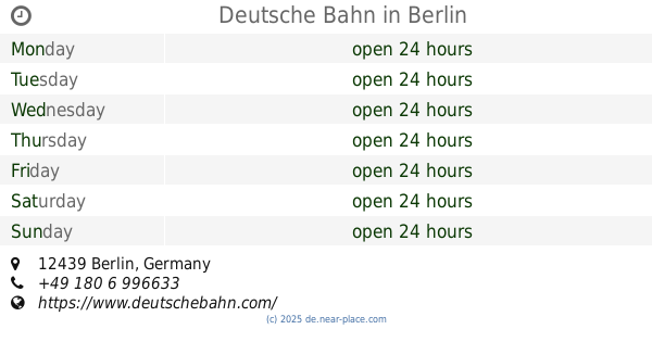
Deutsche Bahn
Berlin
Train station
Transit station
Point of interest
Establishment
read more
3.137 km
Schloßplatz Köpenick (Berlin)
Germany
Transit station
read more
3.262 km
S Schöneweide (Berlin) [Vorplatz]
Germany
Transit station
read more
3.298 km
Schöneweide
Michael-Brückner-Straße 42, Berlin
Train station
Transit station
Point of interest
Establishment
read more
3.324 km
Berlin-Schöneweide
Berlin
Transit station
read more
3.444 km
S Schöneweide/Sterndamm (Berlin)
Germany
Transit station
read more
3.683 km
U Tierpark (Berlin)
Germany
Transit station
read more
3.885 km
S Adlershof (Berlin)
Germany
Transit station
read more
4.329 km
Johannisthal Kirche (Berlin)
Germany
Transit station
read more
4.862 km
U Friedrichsfelde (Berlin)
Germany
Transit station
read more
5.444 km
Friedrichsfelde Ost
Seddiner Straße, Berlin
Transit station
read more
5.864 km
Berlin - Lichtenberg
Weitlingstr. 22, Berlin
Transit station
read more
5.864 km
Berlin, Berlin-Lichtenberg station (train)
Weitlingstr. 22, Berlin
Transit station
read more
6.089 km
S+U Lichtenberg Bhf/Siegfriedstr. (Berlin)
Germany
Transit station
read more
6.558 km
Magdalenenstraße
Germany
Transit station
read more
📑
all categories
Accounting
Administrative area level 1
Administrative area level 2
Airport
Amusement park
Aquarium
Art gallery
Atm
Bakery
Bank
Bar
Beauty salon
Bicycle store
Book store
Bowling alley
Bus station
Cafe
Campground
Car dealer
Car rental
Car repair
Car wash
Casino
Cemetery
Church
City hall
Clothing store
Colloquial area
Convenience store
Country
Courthouse
Dentist
Department store
Doctor
Electrician
Electronics store
Embassy
Establishment
Finance
Fire station
Florist
Food
Funeral home
Furniture store
Gas station
General contractor
Grocery or supermarket
Gym
Hair care
Hardware store
Health
Hindu Temple
Home goods store
Hospital
Insurance agency
Jewelry store
Laundry
Lawyer
Library
Light rail station
Liquor store
Local government office
Locality
Locksmith
Lodging
Meal delivery
Meal takeaway
Mosque
Movie rental
Movie theater
Moving company
Museum
Natural feature
Neighborhood
Night club
Painter
Park
Parking
Pet store
Pharmacy
Physiotherapist
Place of worship
Plumber
Point of interest
Police
Political
Post office
Premise
Real estate agency
Restaurant
Roofing contractor
Route
Rv park, camping
School
Shoe store
Shopping mall
Spa
Stadium
Storage
Store
Subpremise
Subway station
Supermarket
Synagogue
Taxi stand
Train station
Transit station
Travel agency
University
Veterinary care
Zoo
administrative area level 3
administrative area level 4
sublocality level 1
sublocality level 2
sublocality level 3
↑