Food nearby Aral
Coronavirus disease (COVID-19) Situation
confirmed cases
38828995
deaths
183027
Germany
Food nearby Aral
Aral
14, Straße der Jugend, 39517, Tangerhütte, DE Germany
contacts phone
:
+49 3935 213726
website:
map.bp.com
Latitude:
52.4311291
, Longitude:
11.7969933
larger map & directions
read more
nearest Food
8.698 km
Wohnmobilstellplatz La Porte
Im Wald, Bertingen
Campground
Bowling alley
Parking
Lodging
Park
Restaurant
Food
Point of interest
Store
Establishment
read more
8.747 km
La Porte Hotel und Restaurant GmbH & Co. KG
Im Wald 3 39517 Angern, Bertingen
Bowling alley
Campground
Lodging
Park
Restaurant
Food
Point of interest
Store
Establishment
read more
8.938 km
Campingplatz Bertingen (WoMo, WoWa, Zeltler) + Indianer-Tipi-Dorf
Zu den kurzen Enden 1, Bertingen
Campground
Lodging
Park
Restaurant
Food
Point of interest
Establishment
read more
9.188 km
Radler's Rast
Cobbeler Straße 14, Ringfurth
Meal takeaway
Restaurant
Food
Point of interest
Establishment
read more
11.196 km
Gaststätte Bauernschänke Inh. Sabine Leue
Friedensstraße 16, Grieben
Meal takeaway
Restaurant
Food
Point of interest
Establishment
read more
11.741 km
star Tankstelle
Lindenstraße 15, Dolle
Gas station
Car wash
Bakery
Cafe
Food
Point of interest
Store
Establishment
read more
11.839 km
Gaststätte Deichbrücke
Bittkau
Meal takeaway
Restaurant
Food
Point of interest
Establishment
read more
12.012 km
Elbe-Museum
Bucher Kirchstraße 1, Buch
Cafe
Museum
Food
Point of interest
Store
Establishment
read more
12.672 km
Eiscafe swart un witt
Tangermünder Straße 13, Rogätz
Cafe
Food
Point of interest
Store
Establishment
read more
13.281 km
Dein Lieblingsplatz in Parey
Bittkauer Weg 8d, Elbe-Parey
Lodging
Bar
Restaurant
Food
Point of interest
Establishment
read more
13.719 km
Gaststätte Bergschänke
Rudolf-Breitscheid-Straße 16, Elbe-Parey
Bar
Restaurant
Food
Point of interest
Establishment
read more
17.563 km
REWE
Fruchtstraße 1a, Burg (bei Magdeburg)
Supermarket
Grocery or supermarket
Food
Point of interest
Store
Establishment
read more
18.198 km
Tee &Cafè Cult (Teefachgeschäft)
Schartauer Straße 12, Burg (bei Magdeburg)
Cafe
Food
Point of interest
Store
Establishment
read more
18.254 km
TOTAL Tankstelle
Berliner Chaussee 103, Burg (bei Magdeburg)
Gas station
Car wash
Bakery
Cafe
Food
Point of interest
Store
Establishment
read more
18.35 km
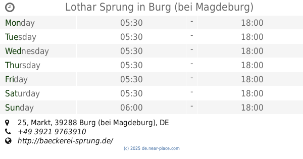
Lothar Sprung
Markt 25, Burg (bei Magdeburg)
Bakery
Food
Point of interest
Store
Establishment
read more
18.893 km
Netto Filiale
Conrad-Tack-Ring 34, Burg (bei Magdeburg)
Supermarket
Grocery or supermarket
Food
Point of interest
Store
Establishment
read more
19.882 km
Mühlenbäcker Düsedau
Lindenstraße 23, Colbitz
Bakery
Food
Point of interest
Store
Establishment
read more
20.16 km
Landhandel Knaup
1, Mose, Farsleber Straße
Liquor store
Food
Point of interest
Store
Establishment
read more
21.463 km
Hotel Jagdschloss Letzlingen
Schloßstraße 10, Gardelegen
Lodging
Restaurant
Food
Point of interest
Establishment
read more
22.436 km
Getränke-Quelle | DIE GETRÄNKEKÖNNER
Rogätzer Straße 27, Wolmirstedt
Liquor store
Food
Point of interest
Store
Establishment
read more
23.979 km
Q1 Tankstelle
An der B1 / Chaussee 29, Möser
Gas station
Car wash
Bakery
Food
Point of interest
Store
Establishment
read more
24.112 km
Netto Filiale
Feldstraße 1, Möser
Supermarket
Grocery or supermarket
Food
Point of interest
Store
Establishment
read more
24.427 km
Max Lüning GmbH & Co. KG
Külzauer Weg 4, Lostau
Supermarket
Grocery or supermarket
Food
Point of interest
Store
Establishment
read more
24.688 km
Schäfer's Brot- und Kuchen Spezialitäten GmbH
Külzauer Weg 1, Möser
Bakery
Food
Point of interest
Store
Establishment
read more
29.742 km
Pfeiffer´s
Johann-Gottlob-Nathusius-Straße 11, Haldensleben
Bakery
Food
Point of interest
Store
Establishment
read more
📑
all categories
Accounting
Administrative area level 1
Administrative area level 2
Airport
Amusement park
Aquarium
Art gallery
Atm
Bakery
Bank
Bar
Beauty salon
Bicycle store
Book store
Bowling alley
Bus station
Cafe
Campground
Car dealer
Car rental
Car repair
Car wash
Casino
Cemetery
Church
City hall
Clothing store
Colloquial area
Convenience store
Country
Courthouse
Dentist
Department store
Doctor
Electrician
Electronics store
Embassy
Establishment
Finance
Fire station
Florist
Food
Funeral home
Furniture store
Gas station
General contractor
Grocery or supermarket
Gym
Hair care
Hardware store
Health
Hindu Temple
Home goods store
Hospital
Insurance agency
Jewelry store
Laundry
Lawyer
Library
Light rail station
Liquor store
Local government office
Locality
Locksmith
Lodging
Meal delivery
Meal takeaway
Mosque
Movie rental
Movie theater
Moving company
Museum
Natural feature
Neighborhood
Night club
Painter
Park
Parking
Pet store
Pharmacy
Physiotherapist
Place of worship
Plumber
Point of interest
Police
Political
Post office
Premise
Real estate agency
Restaurant
Roofing contractor
Route
Rv park, camping
School
Shoe store
Shopping mall
Spa
Stadium
Storage
Store
Subpremise
Subway station
Supermarket
Synagogue
Taxi stand
Train station
Transit station
Travel agency
University
Veterinary care
Zoo
administrative area level 3
administrative area level 4
sublocality level 1
sublocality level 2
sublocality level 3
↑