City hall nearby Bürgeramt branch Hardt
Coronavirus disease (COVID-19) Situation
confirmed cases
38828995
deaths
183027
Germany
City hall nearby Bürgeramt branch Hardt
Bürgeramt branch Hardt
Vorster Straße 443, Mönchengladbach Niemcy
contacts phone
:
+49
Latitude:
51.2024528
, Longitude:
6.3451008
read more
nearest City hall
6.086 km
Rathaus Abtei
Rathausplatz 1, Mönchengladbach
City hall
read more
7.005 km
City Eicken Schuh & Schlüsseldienst
Eickener Straße 132, Mönchengladbach
City hall
read more
8.043 km
City Council Moenchengladbach Rheydt registry office
Markt 11, Mönchengladbach
City hall
read more
8.043 km
Stadtverwaltung Mönchengladbach Standesamt Rheydt
Markt 11, Mönchengladbach
City hall
read more
10.733 km
Technisches Rathaus
Rothweg, Willich
City hall
read more
15.992 km
Rathaus Willich, Standesamt und Schiedsamt
Kaiserplatz 1, Willich
City hall
read more
18.295 km
Rathaus Büttgen
Kaarst
City hall
read more
19.222 km
Stadtverwaltung Kaarst
Am Neumarkt 2, Kaarst
City hall
read more
20.35 km
Fischeln Rathaus
Hafelsstraße 12, Krefeld
City hall
read more
22.099 km
Rathaus Hüls
Hülser Markt 11, Krefeld
City hall
read more
23.602 km
Kreis Verkehrswacht Neuss e V
Büttger Straße 56, Neuss
City hall
read more
24.187 km
Rathaus Neuss
Markt 2, Neuss
City hall
read more
24.232 km
Regionalagentur Mittlerer Niederrhein
Friedrichstraße 40, Neuss
City hall
read more
24.759 km
Stadtverwaltung Stadtverwaltung
Dr.-Franz-Schütz-Platz 1, Meerbusch
City hall
read more
24.773 km
Rathaus Bockum
Uerdinger Straße 585, Krefeld
City hall
read more
25.17 km
Weckhoven alt
Weckhoven
City hall
read more
25.486 km
Lehrbad
Danziger Platz 13, Krefeld
City hall
read more
25.981 km
Forum Wasserturm
Rheinstraße 10, Meerbusch
City hall
read more
26.579 km
Rathaus Traar
Kemmerhofstraße 321, Krefeld
City hall
read more
29.808 km
SMARTCITY Düsseldorf
Marktplatz 2, Düsseldorf
City hall
read more
48.077 km
Stadtverwaltung Leichlingen Rathaus
Am Büscherhof 1, Leichlingen (Rheinland)
City hall
read more
50.327 km
Rathaus Osterfeld
Bottroper Straße 183, Oberhausen
City hall
read more
52.38 km
Historical Archive of the City of Cologne
Heumarkt 14, Köln
City hall
read more
54.485 km
Denkmalpfad Essener Innenstadt
Zwölfling, Essen
City hall
read more
60.773 km
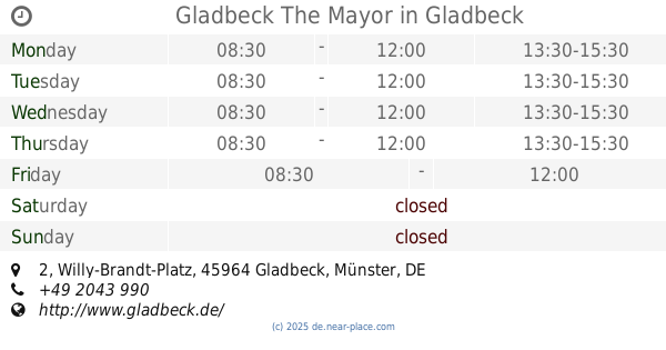
Gladbeck The Mayor
Willy-Brandt-Platz 2, Gladbeck
City hall
read more
📑
all categories
Accounting
Administrative area level 1
Administrative area level 2
Airport
Amusement park
Aquarium
Art gallery
Atm
Bakery
Bank
Bar
Beauty salon
Bicycle store
Book store
Bowling alley
Bus station
Cafe
Campground
Car dealer
Car rental
Car repair
Car wash
Casino
Cemetery
Church
City hall
Clothing store
Colloquial area
Convenience store
Country
Courthouse
Dentist
Department store
Doctor
Electrician
Electronics store
Embassy
Establishment
Finance
Fire station
Florist
Food
Funeral home
Furniture store
Gas station
General contractor
Grocery or supermarket
Gym
Hair care
Hardware store
Health
Hindu Temple
Home goods store
Hospital
Insurance agency
Jewelry store
Laundry
Lawyer
Library
Light rail station
Liquor store
Local government office
Locality
Locksmith
Lodging
Meal delivery
Meal takeaway
Mosque
Movie rental
Movie theater
Moving company
Museum
Natural feature
Neighborhood
Night club
Painter
Park
Parking
Pet store
Pharmacy
Physiotherapist
Place of worship
Plumber
Point of interest
Police
Political
Post office
Premise
Real estate agency
Restaurant
Roofing contractor
Route
Rv park, camping
School
Shoe store
Shopping mall
Spa
Stadium
Storage
Store
Subpremise
Subway station
Supermarket
Synagogue
Taxi stand
Train station
Transit station
Travel agency
University
Veterinary care
Zoo
administrative area level 3
administrative area level 4
sublocality level 1
sublocality level 2
sublocality level 3
↑