City hall nearby Rathaus Osterfeld
Coronavirus disease (COVID-19) Situation
confirmed cases
38828995
deaths
183027
Germany
City hall nearby Rathaus Osterfeld
Rathaus Osterfeld
Bottroper Straße 183, Oberhausen Deutschland
contacts phone
:
+49
Latitude:
51.5013614
, Longitude:
6.8894071
read more
nearest City hall
2.076 km
Stadtverwaltung
Hasenstraße 15, Oberhausen
City hall
read more
3.107 km
Technisches Rathaus
Bahnhofstraße 66, Oberhausen
City hall
read more
3.161 km
Technisches Rathaus Gebäude 2
Oberhausen
City hall
read more
3.245 km
BSG Stadtverwaltung Horst Fassbender
Heimfriedweg 14, Oberhausen
City hall
read more
3.624 km
Rathaus Oberhausen
Schwartzstraße 72, Oberhausen
City hall
read more
8.052 km
Hamborn Rathaus
Duisburger Straße 215, Duisburg
City hall
read more
8.264 km
mh-city.de GmbH
Bachstraße 22-24, Mülheim an der Ruhr
City hall
read more
8.538 km
Stadtverwaltung Duisburg
Walther-Rathenau-Straße 1A, Duisburg
City hall
read more
9.976 km
Stadt Essen
Rathaus, Porschplatz 1, Am Porscheplatz 2, Essen
City hall
read more
9.981 km
Denkmalpfad Essener Innenstadt
Zwölfling, Essen
City hall
read more
10.53 km
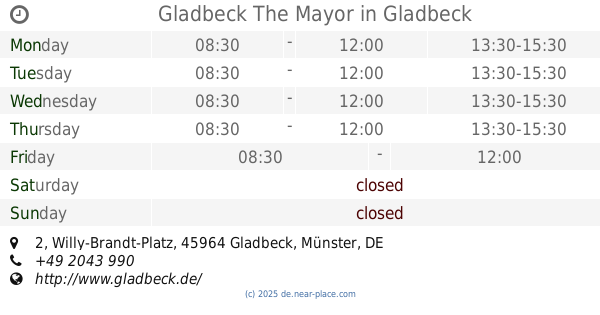
Gladbeck The Mayor
Willy-Brandt-Platz 2, Gladbeck
City hall
read more
10.53 km
Stadtverwaltung Gladbeck
2 Willy-Brandt-Platz, Gladbeck
City hall
read more
10.53 km
Stadt Gladbeck
Willy-Brandt-Platz 2, Gladbeck
City hall
read more
10.603 km
Sterzhausen
Bismarkstrasse 120, Duisburg
City hall
read more
11.539 km
Sören Link Oberbürgermeister Duisburg
Burgplatz 19, Duisburg
City hall
read more
11.993 km
St. Hubertus
Ederstraße 19, Essen
City hall
read more
12.88 km
Stadt Dinslaken
Platz D'Agen 1, Dinslaken
City hall
read more
12.88 km
Stadtarchiv Rathaus
Platz D'Agen 1, Dinslaken
City hall
read more
13.242 km
Stadtverwaltung Duisburg
Rheindeichstraße 22, Duisburg
City hall
read more
13.265 km
Bezirkssportanlage Wedau I
Germany
City hall
read more
14.02 km
Förderverein Rathaus Kray
Kamblickweg 27, Essen
City hall
read more
14.112 km
Hans-Sachs-Haus
Ebertstraße 11, Gelsenkirchen
City hall
read more
14.314 km
Möntingplatz
Möntingplatz 1, Gelsenkirchen
City hall
read more
14.345 km
Stadt Gelsenkirchen
Rathausplatz 2, Gelsenkirchen
City hall
read more
15.304 km
Bürgercenter an der Cranger Straße
Cranger Straße 262, Gelsenkirchen
City hall
read more
📑
all categories
Accounting
Administrative area level 1
Administrative area level 2
Airport
Amusement park
Aquarium
Art gallery
Atm
Bakery
Bank
Bar
Beauty salon
Bicycle store
Book store
Bowling alley
Bus station
Cafe
Campground
Car dealer
Car rental
Car repair
Car wash
Casino
Cemetery
Church
City hall
Clothing store
Colloquial area
Convenience store
Country
Courthouse
Dentist
Department store
Doctor
Electrician
Electronics store
Embassy
Establishment
Finance
Fire station
Florist
Food
Funeral home
Furniture store
Gas station
General contractor
Grocery or supermarket
Gym
Hair care
Hardware store
Health
Hindu Temple
Home goods store
Hospital
Insurance agency
Jewelry store
Laundry
Lawyer
Library
Light rail station
Liquor store
Local government office
Locality
Locksmith
Lodging
Meal delivery
Meal takeaway
Mosque
Movie rental
Movie theater
Moving company
Museum
Natural feature
Neighborhood
Night club
Painter
Park
Parking
Pet store
Pharmacy
Physiotherapist
Place of worship
Plumber
Point of interest
Police
Political
Post office
Premise
Real estate agency
Restaurant
Roofing contractor
Route
Rv park, camping
School
Shoe store
Shopping mall
Spa
Stadium
Storage
Store
Subpremise
Subway station
Supermarket
Synagogue
Taxi stand
Train station
Transit station
Travel agency
University
Veterinary care
Zoo
administrative area level 3
administrative area level 4
sublocality level 1
sublocality level 2
sublocality level 3
↑