University nearby Evangelische Hochschule RWL - Protestant University of Applied Sciences
Germany
University nearby Evangelische Hochschule RWL - Protestant University of Applied Sciences
Evangelische Hochschule RWL - Protestant University of Applied Sciences
Immanuel-Kant-Straße 18-20, Bochum Germany
contacts phone
:
+49
Latitude:
51.4737799
, Longitude:
7.2530443
read more
nearest University
1.413 km
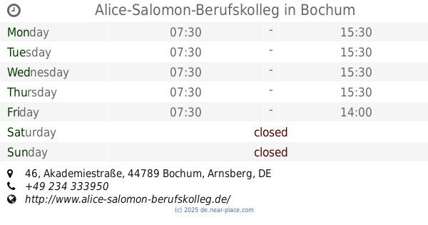
Alice-Salomon-Berufskolleg
Akademiestraße 46, Bochum
University
read more
1.831 km
Gesundheitscampus Bochum
An der Schalwiese, Bochum
University
read more
1.851 km
iba - Internationale Berufsakademie
Universitätsstraße 125, Bochum
University
read more
2.095 km
Technische Berufliche Schule 1
Ostring 25, Bochum
University
read more
2.51 km
UniverCity Bochum
Huestraße 21-23, Projektbüro UniverCity Bochum, c/o Bochum Marketing GmbH, Bochum
University
read more
2.549 km
Hamer Academy - Foto-Workshops
Kortumstraße 24, Bochum
University
read more
2.581 km
TAKE OFF drama school
Meinolphusstraße 10, Bochum
University
read more
2.664 km
COMCAVE.COLLEGE GmbH
Kortumstraße 89, Bochum
University
read more
2.943 km
Evangelische Stadtakademie Bochum
Westring 26c, Bochum
University
read more
2.962 km
Berufsgenossenschaftliches Universitätsklinikum Bergmannsheil GmbH Institut für interventionelle und diagnostische Radiologie und Nuklearmedizin
Bürkle de la Camp-Platz 1, Bochum
University
read more
3.215 km
Technische Hochschule Georg Agricola
Herner Straße 45, Bochum
University
read more
3.231 km
Student union of the University of Bochum
Lennershofstraße 140, Bochum
University
read more
3.693 km
Ruhr-Universität Bochum (Außenstelle Springorum)
Springorumallee 5, Bochum
University
read more
3.702 km
RUB IT.SERVICES
Springorumallee 5, Bochum
University
read more
3.728 km
Taw
Springorumallee, Bochum
University
read more
📑
all categories
Accounting
Administrative area level 1
Administrative area level 2
Airport
Amusement park
Aquarium
Art gallery
Atm
Bakery
Bank
Bar
Beauty salon
Bicycle store
Book store
Bowling alley
Bus station
Cafe
Campground
Car dealer
Car rental
Car repair
Car wash
Casino
Cemetery
Church
City hall
Clothing store
Colloquial area
Convenience store
Country
Courthouse
Dentist
Department store
Doctor
Electrician
Electronics store
Embassy
Establishment
Finance
Fire station
Florist
Food
Funeral home
Furniture store
Gas station
General contractor
Grocery or supermarket
Gym
Hair care
Hardware store
Health
Hindu Temple
Home goods store
Hospital
Insurance agency
Jewelry store
Laundry
Lawyer
Library
Light rail station
Liquor store
Local government office
Locality
Locksmith
Lodging
Meal delivery
Meal takeaway
Mosque
Movie rental
Movie theater
Moving company
Museum
Natural feature
Neighborhood
Night club
Painter
Park
Parking
Pet store
Pharmacy
Physiotherapist
Place of worship
Plumber
Point of interest
Police
Political
Post office
Premise
Real estate agency
Restaurant
Roofing contractor
Route
Rv park, camping
School
Shoe store
Shopping mall
Spa
Stadium
Storage
Store
Subpremise
Subway station
Supermarket
Synagogue
Taxi stand
Train station
Transit station
Travel agency
University
Veterinary care
Zoo
administrative area level 3
administrative area level 4
sublocality level 1
sublocality level 2
sublocality level 3
↑