Supermarket nearby Lidl
Germany
Supermarket nearby Lidl
Lidl
Paul-Gerhardt-Straße 2, Herne Alemania
contacts phone
:
+49
Latitude:
51.5709466
, Longitude:
7.2418043
read more
nearest Supermarket
276 m
Halk Pazari
Emsring 5c, Herne
Supermarket
read more
500 m
Netto
Marienstraße 173, Recklinghausen
Supermarket
read more
500 m
Netto Marken-Discount
Marienstraße 173, Recklinghausen
Supermarket
read more
575 m
PENNY-Markt Discounter
Marienstraße 167, Recklinghausen
Supermarket
read more
575 m
Penny Market
Marienstraße 167, Recklinghausen
Supermarket
read more
1.444 km
REWE
Am Waldschlösschen 32, Recklinghausen
Supermarket
read more
1.469 km
ALDI
Am Waldschlösschen 30, Recklinghausen
Supermarket
read more
1.653 km
EDEKA Vogel
Gneisenaustraße 2, Herne
Supermarket
read more
1.746 km
Netto
Langforthstraße 11, Herne
Supermarket
read more
1.972 km
Lazarus Skłep - Polnische Waren
Marienstraße 6, Recklinghausen
Supermarket
read more
2.102 km
REWE To Go bei Aral
Bochumer Straße 173, Recklinghausen
Supermarket
read more
2.296 km
Getränke Schön - Getränkemarkt & Getränke Lieferservice
Roonstraße 96, Herne
Supermarket
read more
2.318 km
Netto
Roonstraße 63, Herne
Supermarket
read more
2.323 km
Lidl
Berghäuser Straße 1, Recklinghausen
Supermarket
read more
2.597 km
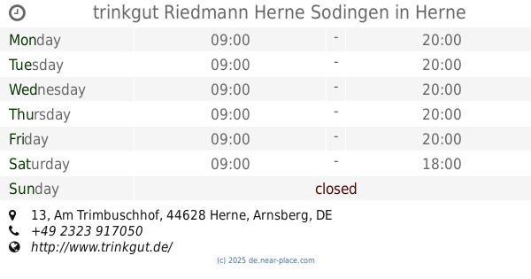
trinkgut Riedmann Herne Sodingen
Am Trimbuschhof 13, Herne
Supermarket
read more
📑
all categories
Accounting
Administrative area level 1
Administrative area level 2
Airport
Amusement park
Aquarium
Art gallery
Atm
Bakery
Bank
Bar
Beauty salon
Bicycle store
Book store
Bowling alley
Bus station
Cafe
Campground
Car dealer
Car rental
Car repair
Car wash
Casino
Cemetery
Church
City hall
Clothing store
Colloquial area
Convenience store
Country
Courthouse
Dentist
Department store
Doctor
Electrician
Electronics store
Embassy
Establishment
Finance
Fire station
Florist
Food
Funeral home
Furniture store
Gas station
General contractor
Grocery or supermarket
Gym
Hair care
Hardware store
Health
Hindu Temple
Home goods store
Hospital
Insurance agency
Jewelry store
Laundry
Lawyer
Library
Light rail station
Liquor store
Local government office
Locality
Locksmith
Lodging
Meal delivery
Meal takeaway
Mosque
Movie rental
Movie theater
Moving company
Museum
Natural feature
Neighborhood
Night club
Painter
Park
Parking
Pet store
Pharmacy
Physiotherapist
Place of worship
Plumber
Point of interest
Police
Political
Post office
Premise
Real estate agency
Restaurant
Roofing contractor
Route
Rv park, camping
School
Shoe store
Shopping mall
Spa
Stadium
Storage
Store
Subpremise
Subway station
Supermarket
Synagogue
Taxi stand
Train station
Transit station
Travel agency
University
Veterinary care
Zoo
administrative area level 3
administrative area level 4
sublocality level 1
sublocality level 2
sublocality level 3
↑