Supermarket nearby ALDI SÜD
Germany
Supermarket nearby ALDI SÜD
ALDI SÜD
80, Schiersteiner Straße, 65187, Wiesbaden, Darmstadt, DE Germany
contacts phone
:
+49 800 8002534
website:
filialen.aldi-sued.de
Latitude:
50.0679556
, Longitude:
8.224559
larger map & directions
read more
nearest Supermarket
209 m
Yazgülü Supermarkt
Schiersteiner Straße 62, Wiesbaden
Supermarket
read more
235 m
REWE
Schiersteiner Straße 58, Wiesbaden
Supermarket
read more
287 m
Nahkauf
Fuchsstraße 2, Wiesbaden
Supermarket
read more
287 m
SPAR Express
Schiersteiner Straße 54, Wiesbaden
Supermarket
read more
721 m
Al-Kazan Supermarkt
Niederwaldstraße 53, Wiesbaden
Supermarket
read more
822 m
SPAR Express
Erich Ollenhauer 195, Wiesbaden
Supermarket
read more
879 m
REWE City
Eltviller Straße 19, Wiesbaden
Supermarket
read more
879 m
REWE
Eltviller Straße 19, Wiesbaden
Supermarket
read more
897 m
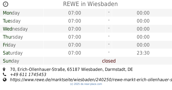
REWE
Erich-Ollenhauer-Straße 70, Wiesbaden
Supermarket
read more
905 m
Stamm Kiosk Wiesbaden
Oestricher Straße, Wiesbaden
Supermarket
read more
1.151 km
PENNY-Markt Discounter
Dotzheimer Straße 150, Wiesbaden
Supermarket
read more
1.231 km
Netto Marken-Discount
Dotzheimer Straße 162, Wiesbaden
Supermarket
read more
1.231 km
Netto
Dotzheimer Straße 162, Wiesbaden
Supermarket
read more
1.964 km
Wcw Westcenter GbR
Flachstraße 13, Wiesbaden
Supermarket
read more
2.128 km
REWE City
Langgasse 32, Wiesbaden
Supermarket
read more
📑
all categories
Accounting
Administrative area level 1
Administrative area level 2
Airport
Amusement park
Aquarium
Art gallery
Atm
Bakery
Bank
Bar
Beauty salon
Bicycle store
Book store
Bowling alley
Bus station
Cafe
Campground
Car dealer
Car rental
Car repair
Car wash
Casino
Cemetery
Church
City hall
Clothing store
Colloquial area
Convenience store
Country
Courthouse
Dentist
Department store
Doctor
Electrician
Electronics store
Embassy
Establishment
Finance
Fire station
Florist
Food
Funeral home
Furniture store
Gas station
General contractor
Grocery or supermarket
Gym
Hair care
Hardware store
Health
Hindu Temple
Home goods store
Hospital
Insurance agency
Jewelry store
Laundry
Lawyer
Library
Light rail station
Liquor store
Local government office
Locality
Locksmith
Lodging
Meal delivery
Meal takeaway
Mosque
Movie rental
Movie theater
Moving company
Museum
Natural feature
Neighborhood
Night club
Painter
Park
Parking
Pet store
Pharmacy
Physiotherapist
Place of worship
Plumber
Point of interest
Police
Political
Post office
Premise
Real estate agency
Restaurant
Roofing contractor
Route
Rv park, camping
School
Shoe store
Shopping mall
Spa
Stadium
Storage
Store
Subpremise
Subway station
Supermarket
Synagogue
Taxi stand
Train station
Transit station
Travel agency
University
Veterinary care
Zoo
administrative area level 3
administrative area level 4
sublocality level 1
sublocality level 2
sublocality level 3
↑