Stadium nearby VELTINS-Arena
Germany
Stadium nearby VELTINS-Arena
VELTINS-Arena
Arenaring 1, Gelsenkirchen Germany
contacts phone
:
+49
Latitude:
51.5546309
, Longitude:
7.0675262
read more
nearest Stadium
1.265 km
Offene Tür
Gelsenkirchen-Nord
Stadium
read more
1.535 km
Bezirkssportanlage Lohmühle
Gelsenkirchen-Nord
Stadium
read more
2.561 km
Rosenhügel
Gelsenkirchen-West
Stadium
read more
2.902 km
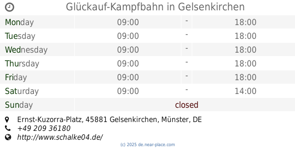
Glückauf-Kampfbahn
Ernst-Kuzorra-Platz, Gelsenkirchen
Stadium
read more
3.504 km
Friedrich-Ludwig-Jahn-Platz
Gelsenkirchen-Mitte
Stadium
read more
4.021 km
Auf dem Schollbruch
Gelsenkirchen-West
Stadium
read more
4.276 km
Fürstenbergstadion
Gelsenkirchen-West
Stadium
read more
4.29 km
Veltins Arena
Gelsenkirchen
Stadium
read more
5.642 km
Vestische Kampfbahn
Bohmertstraße 2, Gladbeck
Stadium
read more
8.043 km
Mondpalast-Arena
Im Sportpark 20, Herne
Stadium
read more
8.344 km
Espenloh
Alemania
Stadium
read more
8.344 km
Espenloh
Niemcy
Stadium
read more
8.426 km
Lohrheidestadion
Lohrheidestraße 82, Bochum
Stadium
read more
9.814 km
Stadion Essen
Hafenstraße 97A, Essen
Stadium
read more
10.598 km
Spielverein Kray 04 e.V.
Schönscheidtstraße 141, 1. Vorsitzender: Thorsten Rossocha, Jugendleiter: Sebastian Naschinski, (Post fach: 13 04 31 in 45294 Essen), Essen
Stadium
read more
12.519 km
Sport- und Spielanlage-Jakobi
Deutschland
Stadium
read more
12.718 km
Waldstadion Rothebusch
Alemania
Stadium
read more
12.987 km
Hibernia Kampfbahn
Recklinghausen
Stadium
read more
13.629 km
Am Wasserturm
Stadtbezirke IV
Stadium
read more
14.105 km
Sport Club Frintrop 05/21 e.V (SC Frintrop)
Schemmannsfeld 27, Essen
Stadium
read more
14.222 km
Sportfreunde Königshardt 1930 e.V.
Pfälzer Straße 59, Oberhausen
Stadium
read more
14.27 km
Ardelhütte
Stadtbezirke IV
Stadium
read more
14.669 km
Uhlenkrug-Stadion
Germany
Stadium
read more
14.906 km
Bezirkssportanlage am Nordbad
Bochum Nord
Stadium
read more
16.693 km
John-Lennon-Platz
Oberhausen
Stadium
read more
📑
all categories
Accounting
Administrative area level 1
Administrative area level 2
Airport
Amusement park
Aquarium
Art gallery
Atm
Bakery
Bank
Bar
Beauty salon
Bicycle store
Book store
Bowling alley
Bus station
Cafe
Campground
Car dealer
Car rental
Car repair
Car wash
Casino
Cemetery
Church
City hall
Clothing store
Colloquial area
Convenience store
Country
Courthouse
Dentist
Department store
Doctor
Electrician
Electronics store
Embassy
Establishment
Finance
Fire station
Florist
Food
Funeral home
Furniture store
Gas station
General contractor
Grocery or supermarket
Gym
Hair care
Hardware store
Health
Hindu Temple
Home goods store
Hospital
Insurance agency
Jewelry store
Laundry
Lawyer
Library
Light rail station
Liquor store
Local government office
Locality
Locksmith
Lodging
Meal delivery
Meal takeaway
Mosque
Movie rental
Movie theater
Moving company
Museum
Natural feature
Neighborhood
Night club
Painter
Park
Parking
Pet store
Pharmacy
Physiotherapist
Place of worship
Plumber
Point of interest
Police
Political
Post office
Premise
Real estate agency
Restaurant
Roofing contractor
Route
Rv park, camping
School
Shoe store
Shopping mall
Spa
Stadium
Storage
Store
Subpremise
Subway station
Supermarket
Synagogue
Taxi stand
Train station
Transit station
Travel agency
University
Veterinary care
Zoo
administrative area level 3
administrative area level 4
sublocality level 1
sublocality level 2
sublocality level 3
↑