Post office nearby DHL Packstation
Germany
Post office nearby DHL Packstation
DHL Packstation
Höhenhöfe 19, Tönisvorst Tyskland
contacts phone
:
+49
Latitude:
51.3161345
, Longitude:
6.4736496
read more
nearest Post office
1.592 km
Deutsche Post
Ringstraße 6, Tönisvorst
Post office
read more
1.605 km
DHL, Postbank, Telekom Kundenzentrum
Ringstraße 6, Tönisvorst
Post office
read more
2.391 km
German Post AG
Plückertzstraße 208, Krefeld
Post office
read more
2.391 km
Birgit Gerdes Postagentur
Plückertzstraße 208, Krefeld
Post office
read more
3.883 km
Deutsche Post Filiale 561
Raumausstattung Siegfried Schmidt, Süchtelner Straße 66, Tönisvorst
Post office
Finance
Point of interest
Establishment
read more
5.955 km
TNT Post Regioservice GmbH
Hülser Straße 702, Krefeld
Post office
read more
7.123 km
Deutsche Post Filiale 550
Philadelphiastraße 81, Krefeld
Post office
Finance
Point of interest
Establishment
read more
8.607 km
Reinhard Pape
Uerdinger Straße 279, Krefeld
Post office
read more
9.103 km
Deutsche Post
Heyenbaumstraße 138, Krefeld
Post office
read more
10.293 km
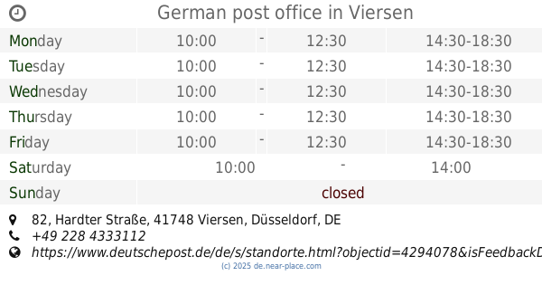
German post office
Reisebüro Hülsmann, Hardter Straße 82, Viersen
Post office
Finance
Point of interest
Establishment
read more
12.872 km
Postfiliale (im Einzelhandel)
Hindenburgstraße 308, Mönchengladbach
Post office
read more
13.597 km
Postbank Finanzcenter
Friedensstraße 22, Kaarst
Post office
read more
13.666 km
Deutsche Post Filiale 548
Lobo food shop, Auf dem Bock 26, Wachtendonk
Post office
Finance
Point of interest
Establishment
read more
14.238 km
Deutsche Post Filiale 516
Eschenweg 8 Barbarossa, Korschenbroich
Post office
Finance
Point of interest
Establishment
read more
15.759 km
Deutsche Post
Rathausallee 8, Duisburg
Post office
read more
📑
all categories
Accounting
Administrative area level 1
Administrative area level 2
Airport
Amusement park
Aquarium
Art gallery
Atm
Bakery
Bank
Bar
Beauty salon
Bicycle store
Book store
Bowling alley
Bus station
Cafe
Campground
Car dealer
Car rental
Car repair
Car wash
Casino
Cemetery
Church
City hall
Clothing store
Colloquial area
Convenience store
Country
Courthouse
Dentist
Department store
Doctor
Electrician
Electronics store
Embassy
Establishment
Finance
Fire station
Florist
Food
Funeral home
Furniture store
Gas station
General contractor
Grocery or supermarket
Gym
Hair care
Hardware store
Health
Hindu Temple
Home goods store
Hospital
Insurance agency
Jewelry store
Laundry
Lawyer
Library
Light rail station
Liquor store
Local government office
Locality
Locksmith
Lodging
Meal delivery
Meal takeaway
Mosque
Movie rental
Movie theater
Moving company
Museum
Natural feature
Neighborhood
Night club
Painter
Park
Parking
Pet store
Pharmacy
Physiotherapist
Place of worship
Plumber
Point of interest
Police
Political
Post office
Premise
Real estate agency
Restaurant
Roofing contractor
Route
Rv park, camping
School
Shoe store
Shopping mall
Spa
Stadium
Storage
Store
Subpremise
Subway station
Supermarket
Synagogue
Taxi stand
Train station
Transit station
Travel agency
University
Veterinary care
Zoo
administrative area level 3
administrative area level 4
sublocality level 1
sublocality level 2
sublocality level 3
↑