Pharmacy nearby Germania Apotheke
Germany
Pharmacy nearby Germania Apotheke
Germania Apotheke
Friedberger Landstraße 72, Frankfurt am Main Niemcy
contacts phone
:
+49
Latitude:
50.1229133
, Longitude:
8.6918172
read more
nearest Pharmacy
177 m
Mercator-Apotheke
Eiserne Hand 3, Frankfurt am Main
Pharmacy
read more
413 m
brocks'sche apotheke
Berger Straße 38, Frankfurt am Main
Pharmacy
read more
498 m
Kepler Apotheke
Eckenheimer Landstraße 73, Frankfurt am Main
Pharmacy
read more
608 m
Sandweg Apotheke
Schellingstraße 1, Frankfurt am Main
Pharmacy
read more
621 m
Höhen-Apotheke Jutta Kraft
Berger Straße 97, Frankfurt am Main
Pharmacy
read more
628 m
LINDA - Schiller Apotheke
Glauburgstraße 64, Frankfurt am Main
Pharmacy
read more
653 m
Rotlint - Apotheke
Rotlintstraße 80, Frankfurt am Main
Pharmacy
read more
745 m
Holzhausen Apotheke
Oeder Weg 72, Frankfurt am Main
Pharmacy
read more
753 m
Schwarzburg Apotheke
Nordendstraße 65, Frankfurt am Main
Pharmacy
read more
772 m
Schwanen-Apotheke
Sandweg 1, Frankfurt am Main
Pharmacy
read more
820 m
Eichwald Apotheke
Berger Straße 131, Frankfurt am Main
Pharmacy
read more
957 m
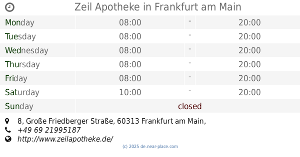
Zeil Apotheke
Große Friedberger Straße 8, Frankfurt am Main
Pharmacy
read more
957 m
Zeil Apotheke zum Mohren
Große Friedberger Straße 8, Frankfurt am Main
Pharmacy
read more
1.041 km
The apple Pharmacy
Zeil 65, Frankfurt am Main
Pharmacy
read more
1.081 km
Centrum-Apotheke
Zeil 96, Frankfurt am Main
Pharmacy
read more
📑
all categories
Accounting
Administrative area level 1
Administrative area level 2
Airport
Amusement park
Aquarium
Art gallery
Atm
Bakery
Bank
Bar
Beauty salon
Bicycle store
Book store
Bowling alley
Bus station
Cafe
Campground
Car dealer
Car rental
Car repair
Car wash
Casino
Cemetery
Church
City hall
Clothing store
Colloquial area
Convenience store
Country
Courthouse
Dentist
Department store
Doctor
Electrician
Electronics store
Embassy
Establishment
Finance
Fire station
Florist
Food
Funeral home
Furniture store
Gas station
General contractor
Grocery or supermarket
Gym
Hair care
Hardware store
Health
Hindu Temple
Home goods store
Hospital
Insurance agency
Jewelry store
Laundry
Lawyer
Library
Light rail station
Liquor store
Local government office
Locality
Locksmith
Lodging
Meal delivery
Meal takeaway
Mosque
Movie rental
Movie theater
Moving company
Museum
Natural feature
Neighborhood
Night club
Painter
Park
Parking
Pet store
Pharmacy
Physiotherapist
Place of worship
Plumber
Point of interest
Police
Political
Post office
Premise
Real estate agency
Restaurant
Roofing contractor
Route
Rv park, camping
School
Shoe store
Shopping mall
Spa
Stadium
Storage
Store
Subpremise
Subway station
Supermarket
Synagogue
Taxi stand
Train station
Transit station
Travel agency
University
Veterinary care
Zoo
administrative area level 3
administrative area level 4
sublocality level 1
sublocality level 2
sublocality level 3
↑