Park nearby Fritz-Encke-Volkspark
Germany
Park nearby Fritz-Encke-Volkspark
Fritz-Encke-Volkspark
Rodenkirchen Germany
contacts phone
:
+49
Latitude:
50.8945399
, Longitude:
6.9585205
read more
nearest Park
958 m
Markusplatz
Rodenkirchen
Park
read more
962 m
Südpark
Rodenkirchen
Park
read more
1.046 km
Kleingärtnerverein Köln-Süd e.V.
Markusstraße 102, Köln
Park
read more
1.071 km
Hundepark Markusstraße
Höninger Weg 381, Köln
Park
read more
1.222 km
Äußerer Grüngürtel
Cologne
Park
read more
1.708 km
Mathiaskirchplatz
Rodenkirchen
Park
read more
1.726 km
Vorgebirgspark
Vorgebirgstraße, Köln
Park
read more
1.777 km
Kgv Schneebergthal
Rondorf, Köln
Park
read more
1.834 km
Vereinsheim KGV Schneeberg Höningen
Jagdweg 8, Köln
Park
read more
1.916 km
Rosenzweig Park
Rosenzweigweg 3, Köln
Park
read more
1.969 km
Kölnpfad, Rodenkirchen
50968, Unnamed Road, Köln
Park
read more
2.001 km
Kalscheurer Weiher
Zollstocker Weg 101, Köln
Park
read more
2.107 km
Vorgebirgsplatz
Rodenkirchen
Park
read more
2.206 km
Michael Müllejans Garten+Forsttechnik
Brühler Landstraße 84, Köln
Park
read more
2.261 km
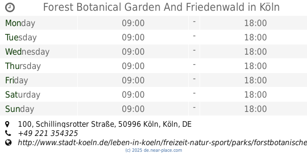
Forest Botanical Garden And Friedenwald
Schillingsrotter Straße 100, Köln
Park
read more
📑
all categories
Accounting
Administrative area level 1
Administrative area level 2
Airport
Amusement park
Aquarium
Art gallery
Atm
Bakery
Bank
Bar
Beauty salon
Bicycle store
Book store
Bowling alley
Bus station
Cafe
Campground
Car dealer
Car rental
Car repair
Car wash
Casino
Cemetery
Church
City hall
Clothing store
Colloquial area
Convenience store
Country
Courthouse
Dentist
Department store
Doctor
Electrician
Electronics store
Embassy
Establishment
Finance
Fire station
Florist
Food
Funeral home
Furniture store
Gas station
General contractor
Grocery or supermarket
Gym
Hair care
Hardware store
Health
Hindu Temple
Home goods store
Hospital
Insurance agency
Jewelry store
Laundry
Lawyer
Library
Light rail station
Liquor store
Local government office
Locality
Locksmith
Lodging
Meal delivery
Meal takeaway
Mosque
Movie rental
Movie theater
Moving company
Museum
Natural feature
Neighborhood
Night club
Painter
Park
Parking
Pet store
Pharmacy
Physiotherapist
Place of worship
Plumber
Point of interest
Police
Political
Post office
Premise
Real estate agency
Restaurant
Roofing contractor
Route
Rv park, camping
School
Shoe store
Shopping mall
Spa
Stadium
Storage
Store
Subpremise
Subway station
Supermarket
Synagogue
Taxi stand
Train station
Transit station
Travel agency
University
Veterinary care
Zoo
administrative area level 3
administrative area level 4
sublocality level 1
sublocality level 2
sublocality level 3
↑