Neighborhood nearby Buer-Mitte
Germany
Neighborhood nearby Buer-Mitte
Buer-Mitte
Buer-Mitte, 45894 Gelsenkirchen, Deutschland
contacts phone
:
+49
Latitude:
51.578669
, Longitude:
7.052616
larger map & directions
read more
nearest Neighborhood
3.861 km
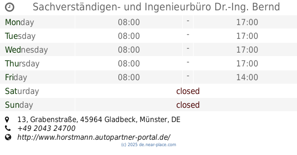
Sachverständigen- und Ingenieurbüro Dr.-Ing. Bernd Horstmann
Sachverständigen- und Ingenieurbüro Dr.-Ing. Bernd Horstmann, Grabenstraße 13, Gladbeck
Neighborhood
read more
4.861 km
CYT DeLuxe GmbH & Co. KG
CYT DeLuxe GmbH & Co. KG, Ebbelicher Weg 70, Herten
Neighborhood
read more
6.057 km
Freiwiese Süd
Langenbochum
Neighborhood
read more
7.009 km
Boy
Bottrop
Neighborhood
read more
7.577 km
Welheim
Bottrop
Neighborhood
read more
9.524 km
Bockholt
Recklinghausen
Neighborhood
read more
9.61 km
Röhlinghausen
Gelsenkirchen-Süd
Neighborhood
read more
10.346 km
Holsterhausen
Herne
Neighborhood
read more
10.413 km
Irmgard Berkowitz
Irmgard Berkowitz, Gildestraße 11, Bottrop
Neighborhood
read more
10.979 km
Hillerheide
Recklinghausen
Neighborhood
read more
11.138 km
Innovation City Management GmbH
Innovation City Management GmbH, Südring-Center-Promenade 3, Bottrop
Neighborhood
read more
12.446 km
Herne-Süd
Herne
Neighborhood
read more
12.737 km
Börste
Recklinghausen
Neighborhood
read more
12.77 km
Nord
Stadtbezirke I
Neighborhood
read more
13.666 km
Freimaurerloge: Freimaurerischer Treffpunkt - Forum Mythologie, Ethik, Philosophie
Freimaurerloge: Freimaurerischer Treffpunkt - Forum Mythologie, Ethik, Philosophie, Friedrich-Ebert-Straße 18, Essen
Neighborhood
read more
14.177 km
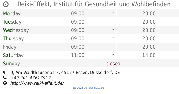
Reiki-Effekt, Institut für Gesundheit und Wohlbefinden Nicole Beyer-Vittinghoff
Reiki-Effekt, Institut für Gesundheit und Wohlbefinden Nicole Beyer-Vittinghoff, Am Waldthausenpark 9, Essen
Neighborhood
read more
14.789 km
Heide
Oberhausen
Neighborhood
read more
15.249 km
Stadtparkviertel
Bochum Mitte
Neighborhood
read more
15.537 km
Neue Mitte
Oberhausen
Neighborhood
read more
15.726 km
Gerberviertel
Bochum Mitte
Neighborhood
read more
16.532 km
Bushaltestelle 345 Richtung Bochum Innenstadt, Bo-Langendreer
Bushaltestelle 345 Richtung Bochum Innenstadt, Bo-Langendreer, Ruhrstraße 84, Bochum
Neighborhood
read more
16.916 km
Arbeitgeberverbände Ruhr/Westfalen
Arbeitgeberverbände Ruhr/Westfalen, Königsallee 67, Bochum
Neighborhood
read more
17.642 km
Winkhausen
Mülheim an der Ruhr
Neighborhood
read more
18.686 km
Kindertagespflege Raupe-Lino, Erzieherin und Tagesmutter Gülsen Kececi
Kindertagespflege Raupe-Lino, Erzieherin und Tagesmutter Gülsen Kececi, Augustastraße 181, Mülheim an der Ruhr
Neighborhood
read more
22.036 km
Menden
Mülheim an der Ruhr
Neighborhood
read more
📑
all categories
Accounting
Administrative area level 1
Administrative area level 2
Airport
Amusement park
Aquarium
Art gallery
Atm
Bakery
Bank
Bar
Beauty salon
Bicycle store
Book store
Bowling alley
Bus station
Cafe
Campground
Car dealer
Car rental
Car repair
Car wash
Casino
Cemetery
Church
City hall
Clothing store
Colloquial area
Convenience store
Country
Courthouse
Dentist
Department store
Doctor
Electrician
Electronics store
Embassy
Establishment
Finance
Fire station
Florist
Food
Funeral home
Furniture store
Gas station
General contractor
Grocery or supermarket
Gym
Hair care
Hardware store
Health
Hindu Temple
Home goods store
Hospital
Insurance agency
Jewelry store
Laundry
Lawyer
Library
Light rail station
Liquor store
Local government office
Locality
Locksmith
Lodging
Meal delivery
Meal takeaway
Mosque
Movie rental
Movie theater
Moving company
Museum
Natural feature
Neighborhood
Night club
Painter
Park
Parking
Pet store
Pharmacy
Physiotherapist
Place of worship
Plumber
Point of interest
Police
Political
Post office
Premise
Real estate agency
Restaurant
Roofing contractor
Route
Rv park, camping
School
Shoe store
Shopping mall
Spa
Stadium
Storage
Store
Subpremise
Subway station
Supermarket
Synagogue
Taxi stand
Train station
Transit station
Travel agency
University
Veterinary care
Zoo
administrative area level 3
administrative area level 4
sublocality level 1
sublocality level 2
sublocality level 3
↑