Local government office nearby Visabox.de
Germany
Local government office nearby Visabox.de
Visabox.de
Adalbertstraße 9, Berlin Deutschland
contacts phone
:
+49
Latitude:
52.5007374
, Longitude:
13.4191154
read more
nearest Local government office
122 m
Quartiersmanagement Zentrum Kreuzberg / Oranienstraße
Dresdener Straße 12, Berlin
Local government office
read more
122 m
Neighborhood Management Center Kreuzberg / Oranienstraße
Dresdener Straße 12, Berlin
Local government office
read more
853 m
TSPA
Lobeckstraße 30, Berlin
Local government office
read more
900 m
Birgit Marzinka
Dieffenbachstraße 76, Berlin
Local government office
read more
1.103 km
Health Department - Child and Youth Health Service
Urbanstraße 24, Berlin
Local government office
read more
1.103 km
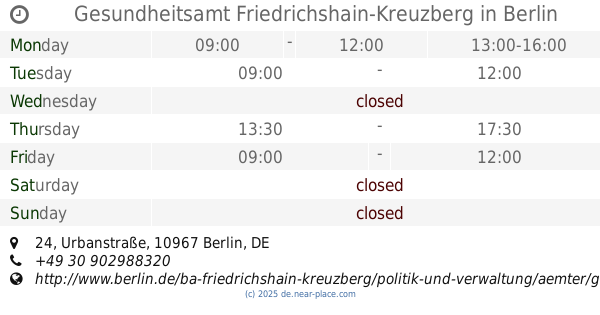
Gesundheitsamt Friedrichshain-Kreuzberg
Curt Bejach Gesundheitshaus, Urbanstraße 24, Berlin
Local government office
read more
1.103 km
Gesundheitsamt - Kinder- und Jugendgesundheitsdienst
Urbanstraße 24, Berlin
Local government office
read more
1.33 km
coopolis gmbh
Lenaustraße 12, Berlin
Local government office
read more
1.407 km
KFZ Gutachten SPREE Berlin & Brandenburg
Wrangelstraße 91, Berlin
Local government office
read more
1.568 km
BVG Service-Punkt
Berlin
Local government office
read more
1.706 km
Technical tax office Berlin
Klosterstraße 59, Berlin
Accounting
Finance
Local government office
Point of interest
Establishment
read more
1.975 km
Landgericht Berlin - Department Littenstraße
Littenstraße 12-17, Berlin
Courthouse
Local government office
Point of interest
Establishment
read more
2.027 km
030-Zulassungsdienst-Berlin/Uwe Blechschmidt
Tempelhofer Ufer 1 b, Berlin
Local government office
read more
2.029 km
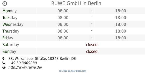
RUWE GmbH
Warschauer Straße 38, Berlin
Local government office
read more
2.154 km
LABO Kfz-Zulassungsbehörde Friedrichshain-Kreuzberg
Jüterboger Straße 3, Berlin
Local government office
read more
📑
all categories
Accounting
Administrative area level 1
Administrative area level 2
Airport
Amusement park
Aquarium
Art gallery
Atm
Bakery
Bank
Bar
Beauty salon
Bicycle store
Book store
Bowling alley
Bus station
Cafe
Campground
Car dealer
Car rental
Car repair
Car wash
Casino
Cemetery
Church
City hall
Clothing store
Colloquial area
Convenience store
Country
Courthouse
Dentist
Department store
Doctor
Electrician
Electronics store
Embassy
Establishment
Finance
Fire station
Florist
Food
Funeral home
Furniture store
Gas station
General contractor
Grocery or supermarket
Gym
Hair care
Hardware store
Health
Hindu Temple
Home goods store
Hospital
Insurance agency
Jewelry store
Laundry
Lawyer
Library
Light rail station
Liquor store
Local government office
Locality
Locksmith
Lodging
Meal delivery
Meal takeaway
Mosque
Movie rental
Movie theater
Moving company
Museum
Natural feature
Neighborhood
Night club
Painter
Park
Parking
Pet store
Pharmacy
Physiotherapist
Place of worship
Plumber
Point of interest
Police
Political
Post office
Premise
Real estate agency
Restaurant
Roofing contractor
Route
Rv park, camping
School
Shoe store
Shopping mall
Spa
Stadium
Storage
Store
Subpremise
Subway station
Supermarket
Synagogue
Taxi stand
Train station
Transit station
Travel agency
University
Veterinary care
Zoo
administrative area level 3
administrative area level 4
sublocality level 1
sublocality level 2
sublocality level 3
↑