Health nearby Thomas Wolf
Germany
Health nearby Thomas Wolf
Thomas Wolf
Horstheider Weg 200, Bielefeld Alemania
contacts phone
:
+49
Latitude:
52.0713
, Longitude:
8.52589
read more
nearest Health
Jutta Wolf Heilpraktikerin
Horstheider Weg 200, Bielefeld
Health
read more
722 m
Hubert Holtkamp
Zur Bülte 21, Bielefeld
Health
read more
1.095 km
Akademiker - KREIS Swart GmbH
Rodeland 20, Bielefeld
Health
read more
1.117 km
Frau Waltraud Meyer-Ilse
Untere Wende 44, Bielefeld
Health
read more
1.608 km
Dr. Theo Schelp, Psychologischer Psychotherapeut und Coach
Splittenbrede 55, Bielefeld
Health
read more
1.611 km
Psychologische Praxis Babenquartier
Splittenbrede 55, Bielefeld
Health
read more
1.642 km
Zukunftsrat Gesundheit
Im Drewer Esch 29, Bielefeld
Health
read more
1.658 km
Regina May Dipl Psych Kinder und Jugendpsychotherapie
Horstheider Weg 99, Bielefeld
Health
read more
1.807 km
1A med GmbH & Co. KG
Westerfeldstraße 50I, Bielefeld
Health
read more
2.212 km
Dimension 21 GmbH Training und Beratung
Hermann-Schäffer-Straße 16, Bielefeld
Health
read more
2.331 km
Praxis für Logopädie Judith Kridde & Team
Westerfeldstraße 8, Bielefeld
Health
read more
2.331 km
Frau Astrid Müller-Bernaschek
Westerfeldstraße 8, Bielefeld
Health
read more
2.424 km
Maria Gnirß
Westerfeldstraße 1, Bielefeld
Health
read more
2.426 km
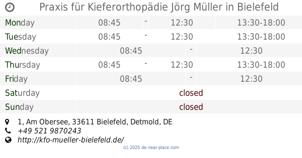
Praxis für Kieferorthopädie Jörg Müller
Am Obersee 1, Bielefeld
Dentist
Health
Point of interest
Establishment
read more
3.355 km
Praxis Lösungswege Claudia Sander
Rappoldstraße 12, Bielefeld
Health
read more
📑
all categories
Accounting
Administrative area level 1
Administrative area level 2
Airport
Amusement park
Aquarium
Art gallery
Atm
Bakery
Bank
Bar
Beauty salon
Bicycle store
Book store
Bowling alley
Bus station
Cafe
Campground
Car dealer
Car rental
Car repair
Car wash
Casino
Cemetery
Church
City hall
Clothing store
Colloquial area
Convenience store
Country
Courthouse
Dentist
Department store
Doctor
Electrician
Electronics store
Embassy
Establishment
Finance
Fire station
Florist
Food
Funeral home
Furniture store
Gas station
General contractor
Grocery or supermarket
Gym
Hair care
Hardware store
Health
Hindu Temple
Home goods store
Hospital
Insurance agency
Jewelry store
Laundry
Lawyer
Library
Light rail station
Liquor store
Local government office
Locality
Locksmith
Lodging
Meal delivery
Meal takeaway
Mosque
Movie rental
Movie theater
Moving company
Museum
Natural feature
Neighborhood
Night club
Painter
Park
Parking
Pet store
Pharmacy
Physiotherapist
Place of worship
Plumber
Point of interest
Police
Political
Post office
Premise
Real estate agency
Restaurant
Roofing contractor
Route
Rv park, camping
School
Shoe store
Shopping mall
Spa
Stadium
Storage
Store
Subpremise
Subway station
Supermarket
Synagogue
Taxi stand
Train station
Transit station
Travel agency
University
Veterinary care
Zoo
administrative area level 3
administrative area level 4
sublocality level 1
sublocality level 2
sublocality level 3
↑