Health nearby Sanipunkt
Germany
Health nearby Sanipunkt
Sanipunkt
11, Reilsheimer Straße, 69245, Bammental, Karlsruhe, DE Germany
contacts phone
:
+49 6223 48476460
Latitude:
49.351762
, Longitude:
8.7761755
larger map & directions
read more
nearest Health
3.821 km
Einrichtungen für Alten und Pflegeheime -Hilfsmittel und Beratung
Lingentaler Hof 4, Leimen
Health
read more
4.797 km
Dr. med. dent. Martina Steffens Fachärztin für Kieferorthopädie
Wiesenbacher Straße 2, Neckargemünd
Dentist
Health
Point of interest
Establishment
read more
6.841 km
Kliniken Schmieder Heidelberg
Speyererhofweg 1, Heidelberg
Hospital
Health
Point of interest
Establishment
read more
6.853 km
Kliniken Schmieder
Speyererhofweg 1, Heidelberg
Health
read more
6.87 km
Kliniken Schmieder Heidelberg
Speyererhofweg, Heidelberg
Health
read more
7.315 km
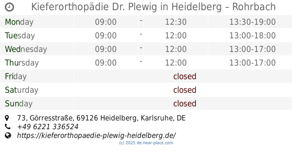
Kieferorthopädie Dr. Plewig in Heidelberg – Rohrbach
Görresstraße 73, Heidelberg
Dentist
Health
Point of interest
Establishment
read more
8.691 km
Radiologisches Zentrum Wiesloch
Schwetzinger Straße 2 a, Wiesloch
Health
read more
8.758 km
Holger Pech Heilpraktiker
Schwetzinger Straße 9, Wiesloch
Health
read more
10.222 km
Universitätsklinikum Heidelberg, Abteilung Allgemeinmedizin und Versorgungsforschung
Marsilius-Arkaden, Im Neuenheimer Feld 130, Heidelberg
Hospital
Health
Point of interest
Establishment
read more
11.208 km
SRH Kurpfalz Hospital Heidelberg GmbH
Bonhoefferstraße 5, Heidelberg
Hospital
Health
Point of interest
Establishment
read more
13.209 km
Christine Engler
Beethovenstraße 22, Dossenheim
Health
read more
13.245 km
Praxis für Ergotherapie & Linkshänderberatung Beatrix Miller
Beethovenstraße 24, Dossenheim
Health
read more
13.245 km
Ursula König Ergotherapeutin
Beethovenstraße 24, Dossenheim
Health
read more
13.249 km
Reinhard Wiegand
Beethovenstraße 24A, Dossenheim
Health
read more
17.633 km
Praxis für Ergotherapie
Praxis für Ergotherapie und Logopädie Mira Strauß, Main-Neckar-Bahn-Straße 76, Edingen-Neckarhausen
Health
read more
📑
all categories
Accounting
Administrative area level 1
Administrative area level 2
Airport
Amusement park
Aquarium
Art gallery
Atm
Bakery
Bank
Bar
Beauty salon
Bicycle store
Book store
Bowling alley
Bus station
Cafe
Campground
Car dealer
Car rental
Car repair
Car wash
Casino
Cemetery
Church
City hall
Clothing store
Colloquial area
Convenience store
Country
Courthouse
Dentist
Department store
Doctor
Electrician
Electronics store
Embassy
Establishment
Finance
Fire station
Florist
Food
Funeral home
Furniture store
Gas station
General contractor
Grocery or supermarket
Gym
Hair care
Hardware store
Health
Hindu Temple
Home goods store
Hospital
Insurance agency
Jewelry store
Laundry
Lawyer
Library
Light rail station
Liquor store
Local government office
Locality
Locksmith
Lodging
Meal delivery
Meal takeaway
Mosque
Movie rental
Movie theater
Moving company
Museum
Natural feature
Neighborhood
Night club
Painter
Park
Parking
Pet store
Pharmacy
Physiotherapist
Place of worship
Plumber
Point of interest
Police
Political
Post office
Premise
Real estate agency
Restaurant
Roofing contractor
Route
Rv park, camping
School
Shoe store
Shopping mall
Spa
Stadium
Storage
Store
Subpremise
Subway station
Supermarket
Synagogue
Taxi stand
Train station
Transit station
Travel agency
University
Veterinary care
Zoo
administrative area level 3
administrative area level 4
sublocality level 1
sublocality level 2
sublocality level 3
↑