Grocery or supermarket nearby Rather Büdchen
Germany
Grocery or supermarket nearby Rather Büdchen
Rather Büdchen
Rösrather Straße 570, Köln Alemania
contacts phone
:
+49
Latitude:
50.92195
, Longitude:
7.08043
read more
nearest Grocery or supermarket
2.243 km
JET Gas Station
Rudolf-Diesel-Straße 32-36, Köln
Gas station
Car wash
Cafe
Supermarket
Book store
Grocery or supermarket
Store
Food
Point of interest
Establishment
read more
2.324 km
real,- Drive Köln-Porz
Rudolf-Diesel-Straße 32, Köln
Grocery or supermarket
read more
2.886 km
Gastronom Russische Lebensmittel
Frankfurter Straße 712, Köln
Grocery or supermarket
read more
2.887 km
Gastronom
Bruchsaler Straße 19, Köln
Grocery or supermarket
read more
3.044 km
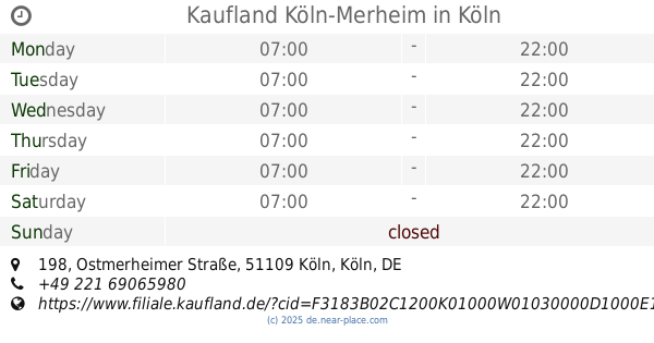
Kaufland Köln-Merheim
Ostmerheimer Straße 198, Köln
Supermarket
Grocery or supermarket
Food
Point of interest
Store
Establishment
read more
3.358 km
ALDI SÜD
Olpener Straße 385-387, Köln
Grocery or supermarket
read more
4.316 km
Mevlana Market
Germany
Grocery or supermarket
read more
4.504 km
Der Kölner Biobauer
Poll-Vingster Straße 215, Köln
Grocery or supermarket
read more
5.866 km
ALDI SÜD
Steyler Straße 15, Köln
Grocery or supermarket
read more
6.104 km
ALDI SÜD
Ackerstraße 92-94, Köln
Grocery or supermarket
read more
6.152 km
Kaufland Köln-Mülheim
Frankfurter Straße 87A, Köln
Supermarket
Grocery or supermarket
Store
Food
Point of interest
Establishment
read more
6.231 km
Aktiv Products
Bergisch Gladbacher Straße 261, Köln
Grocery or supermarket
read more
6.255 km
M. Mertens Fischhandel
Montanusstraße 1, Köln
Grocery or supermarket
read more
6.454 km
JET Tankstelle
Kölner Straße 79, Bergisch Gladbach
Gas station
Supermarket
Book store
Cafe
Grocery or supermarket
Food
Store
Point of interest
Establishment
read more
6.988 km
Harput
Schanzenstraße 6-20, Köln
Grocery or supermarket
read more
📑
all categories
Accounting
Administrative area level 1
Administrative area level 2
Airport
Amusement park
Aquarium
Art gallery
Atm
Bakery
Bank
Bar
Beauty salon
Bicycle store
Book store
Bowling alley
Bus station
Cafe
Campground
Car dealer
Car rental
Car repair
Car wash
Casino
Cemetery
Church
City hall
Clothing store
Colloquial area
Convenience store
Country
Courthouse
Dentist
Department store
Doctor
Electrician
Electronics store
Embassy
Establishment
Finance
Fire station
Florist
Food
Funeral home
Furniture store
Gas station
General contractor
Grocery or supermarket
Gym
Hair care
Hardware store
Health
Hindu Temple
Home goods store
Hospital
Insurance agency
Jewelry store
Laundry
Lawyer
Library
Light rail station
Liquor store
Local government office
Locality
Locksmith
Lodging
Meal delivery
Meal takeaway
Mosque
Movie rental
Movie theater
Moving company
Museum
Natural feature
Neighborhood
Night club
Painter
Park
Parking
Pet store
Pharmacy
Physiotherapist
Place of worship
Plumber
Point of interest
Police
Political
Post office
Premise
Real estate agency
Restaurant
Roofing contractor
Route
Rv park, camping
School
Shoe store
Shopping mall
Spa
Stadium
Storage
Store
Subpremise
Subway station
Supermarket
Synagogue
Taxi stand
Train station
Transit station
Travel agency
University
Veterinary care
Zoo
administrative area level 3
administrative area level 4
sublocality level 1
sublocality level 2
sublocality level 3
↑