Grocery or supermarket nearby JET Tankstelle
Germany
Grocery or supermarket nearby JET Tankstelle
JET Tankstelle
236, Darmstädter Straße, 64625, Bensheim, Darmstadt, DE Germany
contacts phone
:
+49 6251 789015
website:
www.jet.de
Latitude:
49.707
, Longitude:
8.6177
larger map & directions
read more
nearest Grocery or supermarket
4.204 km
Edeka Winkler
In der Pfarrtanne 14, Alsbach-Hähnlein
Supermarket
Grocery or supermarket
Food
Point of interest
Store
Establishment
read more
5.212 km
Spargelverkauf - Hartenauer Hof
Zwingenberger Straße 5, Seeheim-Jugenheim
Grocery or supermarket
read more
10.246 km
Imkerei Meyer
Odenwaldstraße 21, Pfungstadt
Grocery or supermarket
read more
10.933 km
ALDI SÜD
Eberstädter Straße 111, Pfungstadt
Grocery or supermarket
read more
11.168 km
ALDI SÜD
Stresemannstraße 2, Darmstadt
Grocery or supermarket
read more
12.282 km
REWE Supermarkt
Heidelberger Landstrasse 236, Darmstadt
Grocery or supermarket
read more
12.78 km
Naturkost Kornmühle
Heidelberger Landstrasse 186, Darmstadt
Grocery or supermarket
read more
13.066 km
EDEKA Bylitza
Heppenheimer Straße 70, Fürth
Supermarket
Grocery or supermarket
Food
Store
Point of interest
Establishment
read more
15.792 km
Hofladen
Ludwigstraße, Mühltal
Grocery or supermarket
read more
16.035 km
Kaiser Bio-Bäckerei
Darmstädter Straße 35, Mühltal
Grocery or supermarket
read more
16.423 km
ALDI SÜD
Gräfenbergweg 2, Ober-Ramstadt
Grocery or supermarket
read more
24.68 km
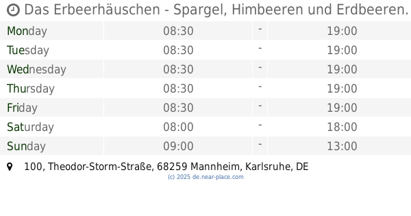
Das Erbeerhäuschen - Spargel, Himbeeren und Erdbeeren.
Theodor-Storm-Straße 100, Mannheim
Grocery or supermarket
read more
26.414 km
Punjabi Shop
G4 14, Mannheim
Grocery or supermarket
read more
26.649 km
Die Bohne Inh. Erhan Uysal Obst Gemüse Feinkost
Q5 23, Mannheim
Grocery or supermarket
read more
26.92 km
Go Asia 东方超市
N7 4, Mannheim
Grocery or supermarket
read more
📑
all categories
Accounting
Administrative area level 1
Administrative area level 2
Airport
Amusement park
Aquarium
Art gallery
Atm
Bakery
Bank
Bar
Beauty salon
Bicycle store
Book store
Bowling alley
Bus station
Cafe
Campground
Car dealer
Car rental
Car repair
Car wash
Casino
Cemetery
Church
City hall
Clothing store
Colloquial area
Convenience store
Country
Courthouse
Dentist
Department store
Doctor
Electrician
Electronics store
Embassy
Establishment
Finance
Fire station
Florist
Food
Funeral home
Furniture store
Gas station
General contractor
Grocery or supermarket
Gym
Hair care
Hardware store
Health
Hindu Temple
Home goods store
Hospital
Insurance agency
Jewelry store
Laundry
Lawyer
Library
Light rail station
Liquor store
Local government office
Locality
Locksmith
Lodging
Meal delivery
Meal takeaway
Mosque
Movie rental
Movie theater
Moving company
Museum
Natural feature
Neighborhood
Night club
Painter
Park
Parking
Pet store
Pharmacy
Physiotherapist
Place of worship
Plumber
Point of interest
Police
Political
Post office
Premise
Real estate agency
Restaurant
Roofing contractor
Route
Rv park, camping
School
Shoe store
Shopping mall
Spa
Stadium
Storage
Store
Subpremise
Subway station
Supermarket
Synagogue
Taxi stand
Train station
Transit station
Travel agency
University
Veterinary care
Zoo
administrative area level 3
administrative area level 4
sublocality level 1
sublocality level 2
sublocality level 3
↑