Gas station nearby Markant Tankstelle
Germany
Gas station nearby Markant Tankstelle
Markant Tankstelle
Elsa-Brändström-Straße 137, Bochum Niemcy
contacts phone
:
+49
Latitude:
51.4561513
, Longitude:
7.1760692
read more
nearest Gas station
942 m
JEM Handels- und Dienstleistungs GmbH
Waldstraße 73a, Bochum
Gas station
read more
1.48 km
Shell
Zeppelindamm 8, Bochum
Gas station
read more
1.54 km
Tank Hof
Germany
Gas station
read more
1.545 km
BFT-Tankhof Petra Stein
Ruhrstraße 211, Bochum
Gas station
read more
1.552 km
BFT Bochum
Ruhrstraße 211, Bochum
Gas station
read more
1.617 km
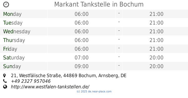
Markant Tankstelle
Westfälische Straße 21, Bochum
Gas station
read more
1.641 km
HEM Tankstelle
Zollstraße 233, Bochum
Gas station
read more
1.744 km
Autogas Bochum
Hattinger Straße 386A, Bochum
Gas station
read more
1.892 km
Aral
Hattinger Straße 451, Bochum
Gas station
read more
2.365 km
Jet
Linden, Bochum
Gas station
read more
2.433 km
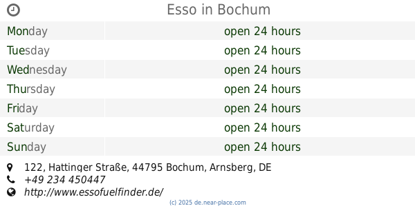
Esso
Hattinger Straße 122, Bochum
Gas station
read more
2.8 km
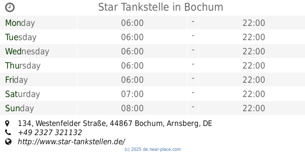
Star Tankstelle
Westenfelder Straße 134, Bochum
Gas station
read more
3.172 km
Aral
Bochumer Straße 6, Bochum
Gas station
read more
3.183 km
Aral Markt
Bochumer Straße 9, Bochum
Gas station
read more
3.239 km
Aral Tankstelle 141146001
Alleestraße 79, Bochum
Gas station
read more
📑
all categories
Accounting
Administrative area level 1
Administrative area level 2
Airport
Amusement park
Aquarium
Art gallery
Atm
Bakery
Bank
Bar
Beauty salon
Bicycle store
Book store
Bowling alley
Bus station
Cafe
Campground
Car dealer
Car rental
Car repair
Car wash
Casino
Cemetery
Church
City hall
Clothing store
Colloquial area
Convenience store
Country
Courthouse
Dentist
Department store
Doctor
Electrician
Electronics store
Embassy
Establishment
Finance
Fire station
Florist
Food
Funeral home
Furniture store
Gas station
General contractor
Grocery or supermarket
Gym
Hair care
Hardware store
Health
Hindu Temple
Home goods store
Hospital
Insurance agency
Jewelry store
Laundry
Lawyer
Library
Light rail station
Liquor store
Local government office
Locality
Locksmith
Lodging
Meal delivery
Meal takeaway
Mosque
Movie rental
Movie theater
Moving company
Museum
Natural feature
Neighborhood
Night club
Painter
Park
Parking
Pet store
Pharmacy
Physiotherapist
Place of worship
Plumber
Point of interest
Police
Political
Post office
Premise
Real estate agency
Restaurant
Roofing contractor
Route
Rv park, camping
School
Shoe store
Shopping mall
Spa
Stadium
Storage
Store
Subpremise
Subway station
Supermarket
Synagogue
Taxi stand
Train station
Transit station
Travel agency
University
Veterinary care
Zoo
administrative area level 3
administrative area level 4
sublocality level 1
sublocality level 2
sublocality level 3
↑