Gas station nearby Lotto-Annahmestelle
Germany
Gas station nearby Lotto-Annahmestelle
Lotto-Annahmestelle
Platter Straße 130, Wiesbaden Deutschland
contacts phone
:
+49
Latitude:
50.0925081
, Longitude:
8.2252163
read more
nearest Gas station
10 m
BFT-Tankstelle
Platter Straße 130, Wiesbaden
Gas station
read more
1.304 km
Markenfreie -Tankstelle
Klarenthaler Straße 44, Wiesbaden
Gas station
read more
1.602 km
Lotto-Verkaufsstelle
Kurt-Schumacher-Ring 6, Wiesbaden
Gas station
read more
1.608 km
Shell
Kurt-Schumacher-Ring 6, Wiesbaden
Gas station
read more
1.672 km
Aral
Dotzheimer Straße 93, Wiesbaden
Gas station
read more
2.182 km
TOTAL Tankstelle
Dotzheimer Straße 184, Wiesbaden
Gas station
read more
2.182 km
Martinsthal
Schlangenbader Straße, Wiesbaden
Gas station
read more
2.26 km
Lotto-Verkaufsstelle
Sonnenberger Straße 82, Wiesbaden
Gas station
read more
2.312 km
Esso
Schönbergstraße 44a, Wiesbaden
Gas station
read more
2.321 km
Lotto-Verkaufsstelle
Schönbergstraße 44A, Wiesbaden
Gas station
read more
2.483 km
JET Tankstelle
Schiersteiner Straße 54, Wiesbaden
Gas station
read more
2.84 km
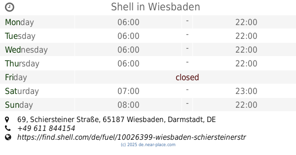
Shell
Schiersteiner Straße 69, Wiesbaden
Gas station
read more
2.901 km
Lotto-Verkaufsstelle
Schiersteiner Straße 92, Wiesbaden
Gas station
read more
3.275 km
Wiesbaden-Hainerberg Express
Washingtonstraße 7883, Wiesbaden
Gas station
read more
3.471 km
Gölün Semerci Tank Center Wiesbaden
Mainzer Straße 104, Wiesbaden
Gas station
read more
📑
all categories
Accounting
Administrative area level 1
Administrative area level 2
Airport
Amusement park
Aquarium
Art gallery
Atm
Bakery
Bank
Bar
Beauty salon
Bicycle store
Book store
Bowling alley
Bus station
Cafe
Campground
Car dealer
Car rental
Car repair
Car wash
Casino
Cemetery
Church
City hall
Clothing store
Colloquial area
Convenience store
Country
Courthouse
Dentist
Department store
Doctor
Electrician
Electronics store
Embassy
Establishment
Finance
Fire station
Florist
Food
Funeral home
Furniture store
Gas station
General contractor
Grocery or supermarket
Gym
Hair care
Hardware store
Health
Hindu Temple
Home goods store
Hospital
Insurance agency
Jewelry store
Laundry
Lawyer
Library
Light rail station
Liquor store
Local government office
Locality
Locksmith
Lodging
Meal delivery
Meal takeaway
Mosque
Movie rental
Movie theater
Moving company
Museum
Natural feature
Neighborhood
Night club
Painter
Park
Parking
Pet store
Pharmacy
Physiotherapist
Place of worship
Plumber
Point of interest
Police
Political
Post office
Premise
Real estate agency
Restaurant
Roofing contractor
Route
Rv park, camping
School
Shoe store
Shopping mall
Spa
Stadium
Storage
Store
Subpremise
Subway station
Supermarket
Synagogue
Taxi stand
Train station
Transit station
Travel agency
University
Veterinary care
Zoo
administrative area level 3
administrative area level 4
sublocality level 1
sublocality level 2
sublocality level 3
↑