Gas station nearby Independent Oberhausen
Germany
Gas station nearby Independent Oberhausen
Independent Oberhausen
5, Lessingstraße, 46149, Oberhausen, Düsseldorf, DE Niemcy
contacts phone
:
+49
Latitude:
51.4970074
, Longitude:
6.8357517
larger map & directions
read more
nearest Gas station
330 m
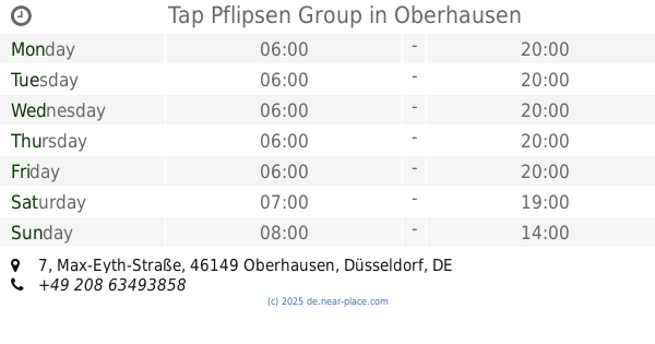
Tap Pflipsen Group
Max-Eyth-Straße 7, Oberhausen
Gas station
read more
596 m
Esso
Westmarkstraße 7, Oberhausen
Gas station
read more
1.594 km
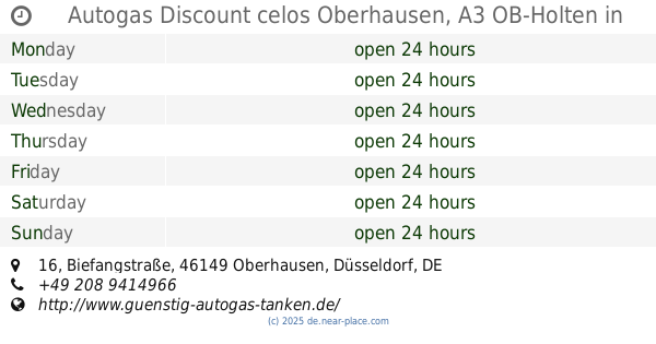
Autogas Discount celos Oberhausen, A3 OB-Holten
Biefangstraße 16, Oberhausen
Gas station
read more
1.645 km
Tankpool24
Zum Eisenhammer 40, Oberhausen
Gas station
read more
1.666 km
Dieter Schmidt
Neumühler Straße 20, Oberhausen
Gas station
read more
1.73 km
Elan-Tankstelle
Konrad-Adenauer-Ring 35, Duisburg
Gas station
read more
1.949 km
TOTAL Tankstelle
Biefangstraße 92, Oberhausen
Gas station
read more
2.001 km
Shell
Duisburger Straße 131, Oberhausen
Gas station
read more
2.013 km
R & M Schwegler GmbH
Duisburger Straße 131, Oberhausen
Gas station
read more
2.213 km
TOTAL Tankstelle
Ruhrorter Straße 65, Oberhausen
Gas station
read more
2.515 km
Tankstelle am Supermarkt
Berliner Straße 90, Duisburg
Gas station
read more
2.596 km
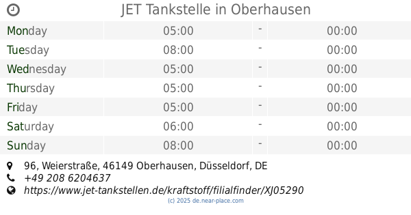
JET Tankstelle
Weierstraße 96, Oberhausen
Gas station
read more
2.616 km
Gas station at the supermarket
Berliner Straße 90, Duisburg
Gas station
read more
2.697 km
Auto DU-Nord de Heuvel GmbH & Co. KG
Theodor-Heuss-Straße 49, Duisburg
Gas station
read more
3.301 km
Aral
Mülheimer Straße 155, Oberhausen
Gas station
read more
📑
all categories
Accounting
Administrative area level 1
Administrative area level 2
Airport
Amusement park
Aquarium
Art gallery
Atm
Bakery
Bank
Bar
Beauty salon
Bicycle store
Book store
Bowling alley
Bus station
Cafe
Campground
Car dealer
Car rental
Car repair
Car wash
Casino
Cemetery
Church
City hall
Clothing store
Colloquial area
Convenience store
Country
Courthouse
Dentist
Department store
Doctor
Electrician
Electronics store
Embassy
Establishment
Finance
Fire station
Florist
Food
Funeral home
Furniture store
Gas station
General contractor
Grocery or supermarket
Gym
Hair care
Hardware store
Health
Hindu Temple
Home goods store
Hospital
Insurance agency
Jewelry store
Laundry
Lawyer
Library
Light rail station
Liquor store
Local government office
Locality
Locksmith
Lodging
Meal delivery
Meal takeaway
Mosque
Movie rental
Movie theater
Moving company
Museum
Natural feature
Neighborhood
Night club
Painter
Park
Parking
Pet store
Pharmacy
Physiotherapist
Place of worship
Plumber
Point of interest
Police
Political
Post office
Premise
Real estate agency
Restaurant
Roofing contractor
Route
Rv park, camping
School
Shoe store
Shopping mall
Spa
Stadium
Storage
Store
Subpremise
Subway station
Supermarket
Synagogue
Taxi stand
Train station
Transit station
Travel agency
University
Veterinary care
Zoo
administrative area level 3
administrative area level 4
sublocality level 1
sublocality level 2
sublocality level 3
↑