Food nearby JET Tankstelle
Germany
Food nearby JET Tankstelle
JET Tankstelle
17, Alte Römerstraße, 85435, Erding, Oberbayern, DE Germany
contacts phone
:
+49 8122 49174
website:
www.jet.de
Latitude:
48.3114
, Longitude:
11.9195
larger map & directions
read more
nearest Food
968 m
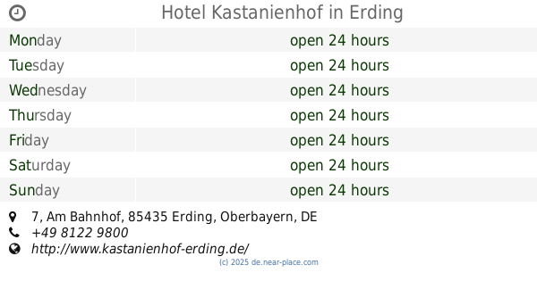
Hotel Kastanienhof
Am Bahnhof 7, Erding
Lodging
Restaurant
Point of interest
Food
Establishment
read more
1.055 km
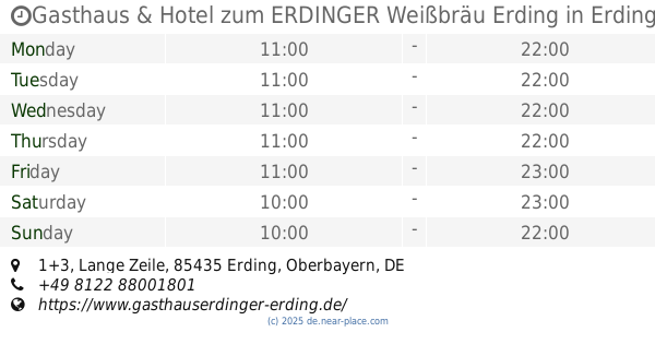
Gasthaus & Hotel zum ERDINGER Weißbräu Erding
Lange Zeile 1+3, Erding
Lodging
Restaurant
Point of interest
Food
Establishment
read more
3.334 km
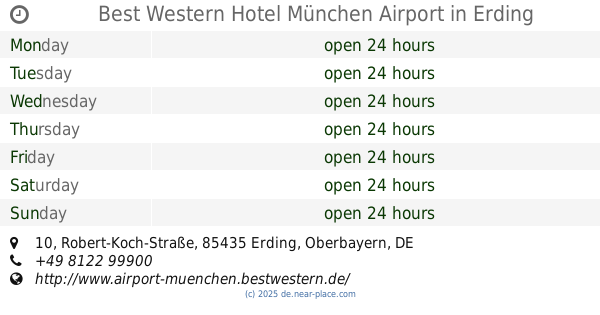
Best Western Hotel München Airport
Robert-Koch-Straße 10, Erding
Lodging
Restaurant
Point of interest
Food
Establishment
read more
6.661 km
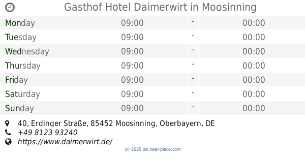
Gasthof Hotel Daimerwirt
Erdinger Straße 40, Moosinning
Lodging
Restaurant
Point of interest
Food
Establishment
read more
13.192 km
Kaufland Freising-Attaching
Raiffeisenstraße 25, Freising
Supermarket
Grocery or supermarket
Store
Food
Point of interest
Establishment
read more
14.4 km
NORMA Filiale
Wallbergstraße 16, Markt Schwaben
Supermarket
Grocery or supermarket
Store
Food
Point of interest
Establishment
read more
17.553 km
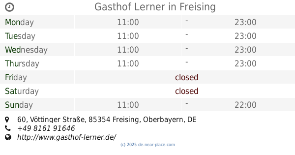
Gasthof Lerner
Vöttinger Straße 60, Freising
Lodging
Restaurant
Food
Point of interest
Establishment
read more
19.138 km
Hotel-Gasthof Maisberger
Bahnhofstraße 54, Neufahrn bei Freising
Restaurant
Lodging
Food
Point of interest
Establishment
read more
30.252 km
Stella del Sud Gastro GmbH
Ismaninger Straße 45, München
Food
read more
30.782 km
Boulder World Munich East
Hanne-Hiob-Straße 4, München
Cafe
Point of interest
Food
Establishment
read more
30.84 km
Royal International Trading GmbH
Breisacher Straße 13, München
Food
read more
31.172 km
ORAIA Lieferdienst
St.-Anna-Straße 15, München
Food
read more
31.926 km
P&R Catering UG (haftungsbeschränkt)
Claudius-Keller-Straße 3, München
Food
read more
32.031 km
Kanne Catering-Service GmbH
Museumsinsel 1, München
Food
read more
33.181 km
Event-Barkeeper.com mobile Cocktailbar Team München
Deisenhofener Straße 17, München
Food
read more
📑
all categories
Accounting
Administrative area level 1
Administrative area level 2
Airport
Amusement park
Aquarium
Art gallery
Atm
Bakery
Bank
Bar
Beauty salon
Bicycle store
Book store
Bowling alley
Bus station
Cafe
Campground
Car dealer
Car rental
Car repair
Car wash
Casino
Cemetery
Church
City hall
Clothing store
Colloquial area
Convenience store
Country
Courthouse
Dentist
Department store
Doctor
Electrician
Electronics store
Embassy
Establishment
Finance
Fire station
Florist
Food
Funeral home
Furniture store
Gas station
General contractor
Grocery or supermarket
Gym
Hair care
Hardware store
Health
Hindu Temple
Home goods store
Hospital
Insurance agency
Jewelry store
Laundry
Lawyer
Library
Light rail station
Liquor store
Local government office
Locality
Locksmith
Lodging
Meal delivery
Meal takeaway
Mosque
Movie rental
Movie theater
Moving company
Museum
Natural feature
Neighborhood
Night club
Painter
Park
Parking
Pet store
Pharmacy
Physiotherapist
Place of worship
Plumber
Point of interest
Police
Political
Post office
Premise
Real estate agency
Restaurant
Roofing contractor
Route
Rv park, camping
School
Shoe store
Shopping mall
Spa
Stadium
Storage
Store
Subpremise
Subway station
Supermarket
Synagogue
Taxi stand
Train station
Transit station
Travel agency
University
Veterinary care
Zoo
administrative area level 3
administrative area level 4
sublocality level 1
sublocality level 2
sublocality level 3
↑