Doctor nearby Freiwilligenakademie OWL
Germany
Doctor nearby Freiwilligenakademie OWL
Freiwilligenakademie OWL
280, Detmolder Straße, 33605, Bielefeld, Detmold, DE Tyskland
contacts phone
:
+49 521 9216444
Latitude:
52.0021273
, Longitude:
8.5671333
larger map & directions
read more
nearest Doctor
474 m
Eva Gahbler-Haus Kinder- und Stadtteiltreff
Gerstenkamp 1A, Bielefeld
Doctor
read more
534 m
mein gyn - Gemeinschaftspraxis Dr. med. Rolf und Martina Englisch und Kollegen
Detmolder Straße 235 7.OG, Bielefeld
Doctor
read more
544 m
Frau Dr. med. Sylvia Schwigon
Steinbruchweg 42, Bielefeld
Doctor
read more
557 m
mein gyn - Gemeinschaftspraxis Dr. Rolf und Martina Englisch & Kollegen
Detmolder Straße 235 7.OG, Bielefeld
Doctor
read more
565 m
Synprax Dr. Henry Stahl
Osningstraße 1, Bielefeld
Doctor
read more
577 m
Dr. med. Johnny Goh
Osningstraße 3, Bielefeld
Doctor
read more
577 m
Dr.med. Johnny Goh
Osningstraße 3, Bielefeld
Doctor
read more
739 m
Hans-Dieter Träbert
Lonnerbachstraße 11, Bielefeld
Doctor
read more
899 m
Dr.med. Gunther Dekkert Facharzt für Innere Medizin
Osningstraße 89, Bielefeld
Doctor
read more
1.161 km
Herr Dr. med. Hans-Joachim Worbs
Bodelschwinghstraße 18, Bielefeld
Doctor
read more
1.179 km
Rühling Konrad. Dipl.-Psych., Psychoanalytiker
Wilbrandstraße 102, Bielefeld
Doctor
read more
1.276 km
Jörg Maß Physiotherapeut
Am Töllenkamp 13, Bielefeld
Doctor
read more
1.349 km
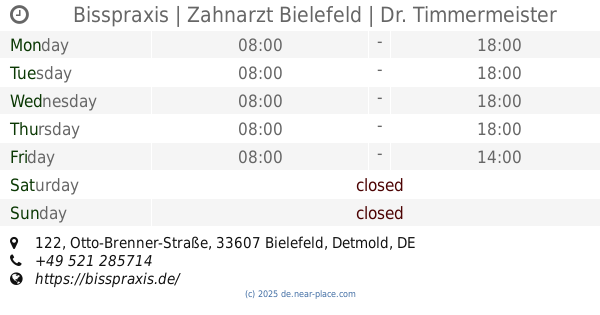
Bisspraxis | Zahnarzt Bielefeld | Dr. Timmermeister + Kollegen
Otto-Brenner-Straße 122, Bielefeld
Dentist
Doctor
Health
Point of interest
Establishment
read more
2.217 km
Group Practice Cardiology | Bielefeld
Oelmühlenstraße 28, Bielefeld
Doctor
read more
2.731 km
Frau Patricia Mähl
August-Bebel-Straße 108A, Bielefeld
Doctor
read more
📑
all categories
Accounting
Administrative area level 1
Administrative area level 2
Airport
Amusement park
Aquarium
Art gallery
Atm
Bakery
Bank
Bar
Beauty salon
Bicycle store
Book store
Bowling alley
Bus station
Cafe
Campground
Car dealer
Car rental
Car repair
Car wash
Casino
Cemetery
Church
City hall
Clothing store
Colloquial area
Convenience store
Country
Courthouse
Dentist
Department store
Doctor
Electrician
Electronics store
Embassy
Establishment
Finance
Fire station
Florist
Food
Funeral home
Furniture store
Gas station
General contractor
Grocery or supermarket
Gym
Hair care
Hardware store
Health
Hindu Temple
Home goods store
Hospital
Insurance agency
Jewelry store
Laundry
Lawyer
Library
Light rail station
Liquor store
Local government office
Locality
Locksmith
Lodging
Meal delivery
Meal takeaway
Mosque
Movie rental
Movie theater
Moving company
Museum
Natural feature
Neighborhood
Night club
Painter
Park
Parking
Pet store
Pharmacy
Physiotherapist
Place of worship
Plumber
Point of interest
Police
Political
Post office
Premise
Real estate agency
Restaurant
Roofing contractor
Route
Rv park, camping
School
Shoe store
Shopping mall
Spa
Stadium
Storage
Store
Subpremise
Subway station
Supermarket
Synagogue
Taxi stand
Train station
Transit station
Travel agency
University
Veterinary care
Zoo
administrative area level 3
administrative area level 4
sublocality level 1
sublocality level 2
sublocality level 3
↑