Dentist nearby Matthias Michel
Germany
Dentist nearby Matthias Michel
Matthias Michel
Heeper Straße 172, Bielefeld Deutschland
contacts phone
:
+49
Latitude:
52.02306
, Longitude:
8.5626
read more
nearest Dentist
233 m
Dr. Michael Meier-Fedeler
Nachtigallstraße 1, Bielefeld
Dentist
read more
233 m
Herr Dr. Michael Meier-Fedeler
Nachtigallstraße 1, Bielefeld
Dentist
read more
254 m
Zahnarztpraxis Dr. med. dent. Ingmar Schau
Nachtigallstraße 1, Bielefeld
Dentist
read more
254 m
Dr. Meier-Fedeler
Nachtigallstraße 1, Bielefeld
Dentist
read more
826 m
Herr Dr. med. dent. Siegfried Heidenreich
Heeper Straße 262, Bielefeld
Dentist
read more
897 m
New Smile Dental GmbH
Mühlenstraße 31, Bielefeld
Dentist
read more
933 m
Dr. med. dent. Paul Erhardt
Otto-Brenner-Straße 112, Bielefeld
Dentist
read more
989 m
Dr.med.dent. Christian Oles Zahnarzt
Meinolfstraße 6, Bielefeld
Dentist
read more
1000 m
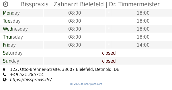
Bisspraxis | Zahnarzt Bielefeld | Dr. Timmermeister + Kollegen
Otto-Brenner-Straße 122, Bielefeld
Dentist
Doctor
Health
Point of interest
Establishment
read more
1000 m
Bisspraxis
Otto-Brenner-Straße 122, Bielefeld
Dentist
read more
1.009 km
Herr Art Timmermeister
Otto-Brenner-Straße 122, Bielefeld
Dentist
read more
1.671 km
Zahnarzt Jochen Ruschhaupt
Viktoriastraße 27, Bielefeld
Dentist
Health
Point of interest
Establishment
read more
1.776 km
Jost-Henrich Zederbohm
Friedrich-Verleger-Straße 7, Bielefeld
Dentist
read more
2.113 km
Zahnarztpraxis für Implantologie Dr. Irfan Durali
Niederwall 67, Bielefeld
Dentist
Health
Point of interest
Establishment
read more
2.113 km
Zahnarztpraxis am Landgericht Dr. Durali & Mosch
Niederwall 67, Bielefeld
Dentist
Health
Point of interest
Establishment
read more
📑
all categories
Accounting
Administrative area level 1
Administrative area level 2
Airport
Amusement park
Aquarium
Art gallery
Atm
Bakery
Bank
Bar
Beauty salon
Bicycle store
Book store
Bowling alley
Bus station
Cafe
Campground
Car dealer
Car rental
Car repair
Car wash
Casino
Cemetery
Church
City hall
Clothing store
Colloquial area
Convenience store
Country
Courthouse
Dentist
Department store
Doctor
Electrician
Electronics store
Embassy
Establishment
Finance
Fire station
Florist
Food
Funeral home
Furniture store
Gas station
General contractor
Grocery or supermarket
Gym
Hair care
Hardware store
Health
Hindu Temple
Home goods store
Hospital
Insurance agency
Jewelry store
Laundry
Lawyer
Library
Light rail station
Liquor store
Local government office
Locality
Locksmith
Lodging
Meal delivery
Meal takeaway
Mosque
Movie rental
Movie theater
Moving company
Museum
Natural feature
Neighborhood
Night club
Painter
Park
Parking
Pet store
Pharmacy
Physiotherapist
Place of worship
Plumber
Point of interest
Police
Political
Post office
Premise
Real estate agency
Restaurant
Roofing contractor
Route
Rv park, camping
School
Shoe store
Shopping mall
Spa
Stadium
Storage
Store
Subpremise
Subway station
Supermarket
Synagogue
Taxi stand
Train station
Transit station
Travel agency
University
Veterinary care
Zoo
administrative area level 3
administrative area level 4
sublocality level 1
sublocality level 2
sublocality level 3
↑