Church nearby Griechisch-Orthodoxe Kirche Hl. Dimitrios
Germany
Church nearby Griechisch-Orthodoxe Kirche Hl. Dimitrios
Griechisch-Orthodoxe Kirche Hl. Dimitrios
Herner Straße 99, Herten Germany
contacts phone
:
+49
Latitude:
51.5809566
, Longitude:
7.158545
read more
nearest Church
Biserica Ortodoxa
Herner Straße 99, Herten
Church
read more
476 m
Johanneskirche
Augustastraße 12, Herten
Church
read more
613 m
St.Joseph
Adalbertstraße 2, Herten
Church
read more
623 m
Katholische Pfarrgemeinde St. Joseph Herten-Süd
Adalbertstraße 2, Herten
Church
read more
1.743 km
Kath. Parish of St. Catherine of Siena
Friedrich-Ebert-Straße 231, Recklinghausen
Church
read more
1.766 km
Kloster Stuckenbusch
Friedrich-Ebert-Straße 231, Recklinghausen
Church
read more
2.134 km
Neuapostolische Kirche
Leopoldstraße 56, Recklinghausen
Church
read more
2.592 km
Außenwohngruppe Wichernhaus
Wiedehopfstraße 31, Gelsenkirchen
Church
read more
2.76 km
St. Josef
Kirchstraße 3, Herten
Church
read more
2.786 km
Matthäus-Haus-Hochlar
Holthoffstraße 20, Recklinghausen
Church
read more
3.021 km
St.Suitbert
Sankt-Suitbert-Platz 9, Recklinghausen
Church
read more
3.022 km
Ev. Kirchengemeinde Hochlarmark
Pestalozzistraße 12, Recklinghausen
Church
read more
3.187 km
Jehovas Zeugen Recklinghausen-Süd
Dieselstraße 2, Recklinghausen
Church
read more
3.241 km
Diakonie Kreis Recklinghausen
Zum Wetterschacht 6, Recklinghausen
Church
read more
3.508 km
Freie evangelische Gemeinde Recklinghausen
Wildermannstraße 51, Recklinghausen
Church
read more
3.615 km
Kath.Herz-Jesu-Kirche
Ahornstraße 48, Gelsenkirchen
Church
read more
3.915 km
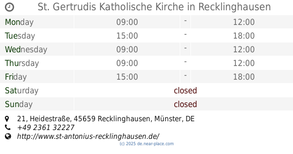
St. Gertrudis Katholische Kirche
Heidestraße 21, Recklinghausen
Church
read more
3.938 km
Evangelischen Kirchengemeinde Recklinghausen-Süd
Bochumer Straße 163, Recklinghausen
Church
read more
4.515 km
Gastkirche und Gasthaus
Heilige-Geist-Straße 7, Recklinghausen
Church
read more
4.903 km
Kath. Kirchengemeinde Liebfrauen
Liebfrauenstraße 1, Recklinghausen
Church
read more
4.94 km
St. Lawrence Church
Hauptstraße 317, Herne
Church
read more
5.155 km
Katholische Kirchengemeinde St. Marien
Bismarckstraße 72a, Herne
Church
read more
5.485 km
Bleckkirche
Bleckstraße 1, Gelsenkirchen
Church
read more
6.563 km
Sankt Bonifatius
Glockenstraße 7, Herne
Church
read more
6.867 km
Stadtverwaltung Senioren Beratungsstelle
Mont-Cenis-Straße 32, Herne
Church
read more
📑
all categories
Accounting
Administrative area level 1
Administrative area level 2
Airport
Amusement park
Aquarium
Art gallery
Atm
Bakery
Bank
Bar
Beauty salon
Bicycle store
Book store
Bowling alley
Bus station
Cafe
Campground
Car dealer
Car rental
Car repair
Car wash
Casino
Cemetery
Church
City hall
Clothing store
Colloquial area
Convenience store
Country
Courthouse
Dentist
Department store
Doctor
Electrician
Electronics store
Embassy
Establishment
Finance
Fire station
Florist
Food
Funeral home
Furniture store
Gas station
General contractor
Grocery or supermarket
Gym
Hair care
Hardware store
Health
Hindu Temple
Home goods store
Hospital
Insurance agency
Jewelry store
Laundry
Lawyer
Library
Light rail station
Liquor store
Local government office
Locality
Locksmith
Lodging
Meal delivery
Meal takeaway
Mosque
Movie rental
Movie theater
Moving company
Museum
Natural feature
Neighborhood
Night club
Painter
Park
Parking
Pet store
Pharmacy
Physiotherapist
Place of worship
Plumber
Point of interest
Police
Political
Post office
Premise
Real estate agency
Restaurant
Roofing contractor
Route
Rv park, camping
School
Shoe store
Shopping mall
Spa
Stadium
Storage
Store
Subpremise
Subway station
Supermarket
Synagogue
Taxi stand
Train station
Transit station
Travel agency
University
Veterinary care
Zoo
administrative area level 3
administrative area level 4
sublocality level 1
sublocality level 2
sublocality level 3
↑