Church nearby Ev. Kirchengemeinde Essen-Borbeck-Vogelheim
Germany
Church nearby Ev. Kirchengemeinde Essen-Borbeck-Vogelheim
Ev. Kirchengemeinde Essen-Borbeck-Vogelheim
Prosperstraße 87, Essen Germany
contacts phone
:
+49
Latitude:
51.4944974
, Longitude:
6.9343719
read more
nearest Church
275 m
Evangel. Kirchengemeinde
Vieselmanns Ried 8, Essen
Church
read more
1.066 km
Matthiashaus Bottrop-Ebel e.V.
Hafenstraße 78, Bottrop
Church
read more
1.669 km
Kirche St. Judas Thaddäus
Einbleckstraße 20, Oberhausen
Church
read more
2.06 km
Filialkirche St. Suitbert
Am Freitagshof 16, Bottrop
Church
read more
2.091 km
Ev. Jugend, Arche Noah
Grünewaldstraße 33, Bottrop
Church
read more
2.091 km
Arche Noah
Grünewaldstraße 33, Bottrop
Church
read more
2.156 km
Evangelische Predigtstätte Vonderort
Am Wienberg, Bottrop
Church
read more
2.592 km
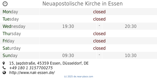
Neuapostolische Kirche
Jagdstraße 15, Essen
Church
read more
2.604 km
Neuapostolische Kirche
Germaniastraße 220, Essen
Church
read more
2.715 km
Gemeindekirche Herz Jesu
Prosperstraße 32, Bottrop
Church
read more
2.989 km
Pfarr- und Gemeindekirche Propstei St. Cyriakus
Hochstraße, Bottrop
Church
read more
2.989 km
Provost Church of St. Cyriac
Hochstraße, Bottrop
Church
read more
3.02 km
St. Michaelskirche Batenbrock-Süd
Glückaufstraße 5 a, Bottrop
Church
read more
3.246 km
Evangelische Kirchengemeinde Bottrop
Osterfelder Straße 11, Bottrop
Church
read more
3.283 km
St. Pankratius
Nürnberger Straße 6, Oberhausen
Church
read more
3.47 km
Evangelische Gemeinschaft Heilandgemeinde Bottrop
Sonnenschein 50, Bottrop
Church
read more
3.484 km
liberty chapel International
Hausmannsfeld 12, Oberhausen
Church
read more
3.741 km
St.Marien Rothebusch
Leutweinstraße, Oberhausen
Church
read more
4.082 km
Kapelle Herbert
Talstraße 58 B, Mülheim an der Ruhr
Church
read more
4.183 km
St. Ludgeruskirche
Birkenstraße 73, Bottrop
Church
read more
5.181 km
Evangelisch-Freikirchlichen Gemeinde Oberhausen
Walter-Flex-Straße 13-17, Oberhausen
Church
read more
5.583 km
Seniorentreff der Evangelischen Kirchengemeinde Essen-Karnap
Hattramstraße 33, Essen
Church
read more
5.935 km
Auferstehungskirche Heilig Kreuz
Tiegelstraße 100, Mülheim an der Ruhr
Church
read more
6.276 km
ICF Essen
Berliner Platz 4, Essen
Church
read more
6.635 km
Die Heilsarmee Korps Essen
Lazarettstraße 10, Essen
Church
read more
📑
all categories
Accounting
Administrative area level 1
Administrative area level 2
Airport
Amusement park
Aquarium
Art gallery
Atm
Bakery
Bank
Bar
Beauty salon
Bicycle store
Book store
Bowling alley
Bus station
Cafe
Campground
Car dealer
Car rental
Car repair
Car wash
Casino
Cemetery
Church
City hall
Clothing store
Colloquial area
Convenience store
Country
Courthouse
Dentist
Department store
Doctor
Electrician
Electronics store
Embassy
Establishment
Finance
Fire station
Florist
Food
Funeral home
Furniture store
Gas station
General contractor
Grocery or supermarket
Gym
Hair care
Hardware store
Health
Hindu Temple
Home goods store
Hospital
Insurance agency
Jewelry store
Laundry
Lawyer
Library
Light rail station
Liquor store
Local government office
Locality
Locksmith
Lodging
Meal delivery
Meal takeaway
Mosque
Movie rental
Movie theater
Moving company
Museum
Natural feature
Neighborhood
Night club
Painter
Park
Parking
Pet store
Pharmacy
Physiotherapist
Place of worship
Plumber
Point of interest
Police
Political
Post office
Premise
Real estate agency
Restaurant
Roofing contractor
Route
Rv park, camping
School
Shoe store
Shopping mall
Spa
Stadium
Storage
Store
Subpremise
Subway station
Supermarket
Synagogue
Taxi stand
Train station
Transit station
Travel agency
University
Veterinary care
Zoo
administrative area level 3
administrative area level 4
sublocality level 1
sublocality level 2
sublocality level 3
↑