Cafe nearby Heides Red Cafè
Germany
Cafe nearby Heides Red Cafè
Heides Red Cafè
Lange Straße 71, Halle (Westfalen) Deutschland
contacts phone
:
+49
Latitude:
52.0595107
, Longitude:
8.3652338
read more
nearest Cafe
404 m
Conditorei Baier
Bahnhofstraße 33, Halle (Westfalen)
Cafe
read more
1.359 km
Beuken Schmedt
Alleestraße 41, Halle (Westfalen)
Cafe
read more
3.419 km
Brockmeyer Cafe
Werkstraße 2, Halle (Westfalen)
Cafe
read more
3.61 km
Eiscafé Venezia
Alte Bielefelder Straße 11, Werther (Westfalen)
Cafe
read more
3.898 km
Grill & Kaffeehaus Ralf Kleinemas
Ravenna-Park 3, Halle (Westfalen)
Cafe
read more
6.497 km
Schulze Laden & Café
Freistraße 23, Borgholzhausen
Cafe
Food
Point of interest
Store
Establishment
read more
6.978 km
Baier T.
Voßheide 23, Steinhagen
Cafe
read more
11.831 km
Moccaklatsch - Bielefeld
Arndtstraße 11, Bielefeld
Cafe
Meal takeaway
Bar
Restaurant
Food
Point of interest
Establishment
read more
12.465 km
Bauernhofcafé Unnern Äiken
Niehorster Straße 110, Gütersloh
Cafe
read more
12.836 km
Konditorei Café Bürenkemper
Steinhagener Straße 2, Gütersloh
Cafe
read more
13.471 km
Elite Bowling Center - Bielefeld
Huberstraße 25, Bielefeld
Bowling alley
Cafe
Night club
Bar
Restaurant
Food
Point of interest
Establishment
read more
14.368 km
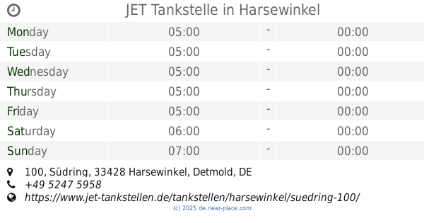
JET Tankstelle
Südring 100, Harsewinkel
Gas station
Car wash
Book store
Supermarket
Grocery or supermarket
Cafe
Restaurant
Food
Point of interest
Store
Establishment
read more
14.538 km
Hotel Drei Birken
Birkenstraße 3, Bad Rothenfelde
Cafe
Spa
Lodging
Restaurant
Food
Point of interest
Establishment
read more
15.215 km
Parkhotel Gätje
Parkstraße 10, Bad Rothenfelde
Cafe
Lodging
Bar
Restaurant
Food
Point of interest
Establishment
read more
15.778 km
Eiscafé Amigelato Friedrichsdorf
Brackweder Straße 33, Gütersloh
Cafe
read more
📑
all categories
Accounting
Administrative area level 1
Administrative area level 2
Airport
Amusement park
Aquarium
Art gallery
Atm
Bakery
Bank
Bar
Beauty salon
Bicycle store
Book store
Bowling alley
Bus station
Cafe
Campground
Car dealer
Car rental
Car repair
Car wash
Casino
Cemetery
Church
City hall
Clothing store
Colloquial area
Convenience store
Country
Courthouse
Dentist
Department store
Doctor
Electrician
Electronics store
Embassy
Establishment
Finance
Fire station
Florist
Food
Funeral home
Furniture store
Gas station
General contractor
Grocery or supermarket
Gym
Hair care
Hardware store
Health
Hindu Temple
Home goods store
Hospital
Insurance agency
Jewelry store
Laundry
Lawyer
Library
Light rail station
Liquor store
Local government office
Locality
Locksmith
Lodging
Meal delivery
Meal takeaway
Mosque
Movie rental
Movie theater
Moving company
Museum
Natural feature
Neighborhood
Night club
Painter
Park
Parking
Pet store
Pharmacy
Physiotherapist
Place of worship
Plumber
Point of interest
Police
Political
Post office
Premise
Real estate agency
Restaurant
Roofing contractor
Route
Rv park, camping
School
Shoe store
Shopping mall
Spa
Stadium
Storage
Store
Subpremise
Subway station
Supermarket
Synagogue
Taxi stand
Train station
Transit station
Travel agency
University
Veterinary care
Zoo
administrative area level 3
administrative area level 4
sublocality level 1
sublocality level 2
sublocality level 3
↑