Bar nearby FRIEDA Bar
Coronavirus disease (COVID-19) Situation
confirmed cases
38828995
deaths
183027
Germany
Bar nearby FRIEDA Bar
FRIEDA Bar
53, Antwerpener Straße, 50672, Köln, Köln, DE Deutschland
contacts phone
:
+49 221 80006186
website:
www.frieda-bar.de
Latitude:
50.940043
, Longitude:
6.9340079
larger map & directions
read more
nearest Bar
205 m
GEDANKENtanken Gastro GmbH
Genter Straße 8, Köln
Bar
read more
246 m
Monkeys Cocktail Culture
Venloer Straße 33, Köln
Bar
read more
269 m
The Harp
Venloer Straße 22, Köln
Bar
read more
341 m
LC36
Ludolf-Camphausen-Straße 36, Köln
Bar
read more
410 m
# Tausend
Aachener Straße 57, Köln
Bar
read more
480 m
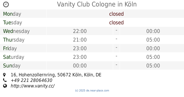
Vanity Club Cologne
Hohenzollernring 16, Köln
Bar
read more
496 m
Unikat
Im Klapperhof 49, Köln
Bar
read more
514 m
Love Story Discothek & Bar GmbH
Friesenwall 116, Köln
Bar
read more
550 m
11cl Cocktailkurse @ Abhörbar
Friesenwall 128, Köln
Bar
read more
551 m
Brauerei Päffgen
Friesenstraße 64-66, Köln
Bar
read more
580 m
Goldfinger
Friesenstraße 54, Köln
Bar
read more
622 m
Köwa
Im Klapperhof 29, Köln
Bar
read more
631 m
Maracana Rodizio
Friesenstraße 55, Köln
Bar
read more
657 m
Santa Clara GmbH
Friesenstraße 47, Köln
Bar
read more
668 m
Hemingway
Friesenstraße 43, Köln
Bar
read more
680 m
Friesen Bar
Friesenstraße 41, Köln
Bar
read more
731 m
ONA MOR Bar
Roonstraße 94, Köln
Bar
read more
763 m
Zentralgarderobe Bermudadreieck
Schaafenstraße 49, Köln
Bar
read more
862 m
DOMCUP Gastroverwaltungs GmbH
Apostelnstraße 2, Köln
Bar
read more
864 m
Mariechen
51, Am Rinkenpfuhl, Köln
Bar
read more
871 m
MD BAR
Marsilstein 21-23, Köln
Bar
read more
946 m
Qlosterstüffje
Venloer Straße 221, Köln
Bar
read more
1.163 km
Königsblut
Thebäerstraße 8, Köln
Bar
read more
1.164 km
The Bär
Thebäerstraße 10, Köln
Bar
read more
1.291 km
ycb your coffee brands GmbH
Hansaring 61, Köln
Bar
read more
📑
all categories
Accounting
Administrative area level 1
Administrative area level 2
Airport
Amusement park
Aquarium
Art gallery
Atm
Bakery
Bank
Bar
Beauty salon
Bicycle store
Book store
Bowling alley
Bus station
Cafe
Campground
Car dealer
Car rental
Car repair
Car wash
Casino
Cemetery
Church
City hall
Clothing store
Colloquial area
Convenience store
Country
Courthouse
Dentist
Department store
Doctor
Electrician
Electronics store
Embassy
Establishment
Finance
Fire station
Florist
Food
Funeral home
Furniture store
Gas station
General contractor
Grocery or supermarket
Gym
Hair care
Hardware store
Health
Hindu Temple
Home goods store
Hospital
Insurance agency
Jewelry store
Laundry
Lawyer
Library
Light rail station
Liquor store
Local government office
Locality
Locksmith
Lodging
Meal delivery
Meal takeaway
Mosque
Movie rental
Movie theater
Moving company
Museum
Natural feature
Neighborhood
Night club
Painter
Park
Parking
Pet store
Pharmacy
Physiotherapist
Place of worship
Plumber
Point of interest
Police
Political
Post office
Premise
Real estate agency
Restaurant
Roofing contractor
Route
Rv park, camping
School
Shoe store
Shopping mall
Spa
Stadium
Storage
Store
Subpremise
Subway station
Supermarket
Synagogue
Taxi stand
Train station
Transit station
Travel agency
University
Veterinary care
Zoo
administrative area level 3
administrative area level 4
sublocality level 1
sublocality level 2
sublocality level 3
↑