Bakery nearby Der Bäcker Eifler
Germany
Bakery nearby Der Bäcker Eifler
Der Bäcker Eifler
Willy-Brandt-Platz 1, Frankfurt am Main Niemcy
contacts phone
:
+49
Latitude:
50.1088746
, Longitude:
8.6745081
read more
nearest Bakery
275 m
Brötchenmacher
Kirchnerstraße 5, Frankfurt am Main
Bakery
read more
430 m
Kaiserzeit
Kaiserstraße 59, Frankfurt am Main
Bakery
read more
443 m
Brot und seine Freunde
Kornmarkt 5, Frankfurt am Main
Bakery
read more
660 m
Schirn Café Bar Restaurant - Frankfurt am Main
Schirn Kunsthalle, Römerberg, Frankfurt am Main
Restaurant
Bakery
Cafe
Store
Food
Point of interest
Establishment
read more
660 m
Schirn Café Bar Restaurant
Schirn Kunsthalle, Römerberg, Frankfurt am Main
Restaurant
Cafe
Bakery
Store
Food
Point of interest
Establishment
read more
660 m
Badias Schirn Café Bar Restaurant
Schirn Kunsthalle, Römerberg, Frankfurt am Main
Restaurant
Cafe
Bakery
Store
Food
Point of interest
Establishment
read more
805 m
Metropol am Dom - Café & Restaurant
Weckmarkt 15, Frankfurt am Main
Cafe
Bar
Bakery
Store
Restaurant
Food
Point of interest
Establishment
read more
847 m
Wiener Feinbäcker
Hasengasse 19, Frankfurt am Main
Bakery
read more
961 m
Kaiser Biobäckerei
Schweizer Straße 68, Frankfurt / Main
Bakery
read more
998 m
Wiener Feinbäckerei
Düsseldorfer Straße 19, Frankfurt am Main
Bakery
read more
1.009 km
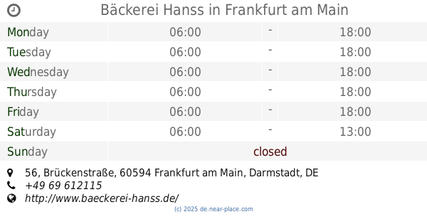
Bäckerei Hanss
Brückenstraße 56, Frankfurt am Main
Bakery
read more
1.025 km
La Maison du Pain Schweizer Strasse
Schweizer Straße 63, Frankfurt am Main Süd
Cafe
Meal takeaway
Bakery
Store
Restaurant
Food
Point of interest
Establishment
read more
1.063 km
Bäckerei Jürgen Wolf GmbH
Schweizer Straße 82, Frankfurt am Main
Bakery
read more
1.154 km
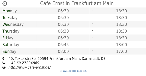
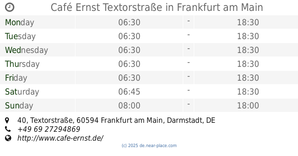
Café Ernst Textorstraße
Textorstraße 40, Frankfurt am Main
Bakery
read more
1.156 km
Cafe Ernst
Textorstraße 40, Frankfurt am Main
Bakery
Cafe
Store
Food
Point of interest
Establishment
read more
📑
all categories
Accounting
Administrative area level 1
Administrative area level 2
Airport
Amusement park
Aquarium
Art gallery
Atm
Bakery
Bank
Bar
Beauty salon
Bicycle store
Book store
Bowling alley
Bus station
Cafe
Campground
Car dealer
Car rental
Car repair
Car wash
Casino
Cemetery
Church
City hall
Clothing store
Colloquial area
Convenience store
Country
Courthouse
Dentist
Department store
Doctor
Electrician
Electronics store
Embassy
Establishment
Finance
Fire station
Florist
Food
Funeral home
Furniture store
Gas station
General contractor
Grocery or supermarket
Gym
Hair care
Hardware store
Health
Hindu Temple
Home goods store
Hospital
Insurance agency
Jewelry store
Laundry
Lawyer
Library
Light rail station
Liquor store
Local government office
Locality
Locksmith
Lodging
Meal delivery
Meal takeaway
Mosque
Movie rental
Movie theater
Moving company
Museum
Natural feature
Neighborhood
Night club
Painter
Park
Parking
Pet store
Pharmacy
Physiotherapist
Place of worship
Plumber
Point of interest
Police
Political
Post office
Premise
Real estate agency
Restaurant
Roofing contractor
Route
Rv park, camping
School
Shoe store
Shopping mall
Spa
Stadium
Storage
Store
Subpremise
Subway station
Supermarket
Synagogue
Taxi stand
Train station
Transit station
Travel agency
University
Veterinary care
Zoo
administrative area level 3
administrative area level 4
sublocality level 1
sublocality level 2
sublocality level 3
↑