Bakery nearby Café Kiess - Würzburg
Germany
Bakery nearby Café Kiess - Würzburg
Café Kiess - Würzburg
6, Kaiserstraße, 97070, Würzburg, Unterfranken, DE Germany
contacts phone
:
+49 931 52638
website:
www.cafe-kiess.de
Latitude:
49.7982549
, Longitude:
9.9338611
larger map & directions
read more
nearest Bakery
42 m
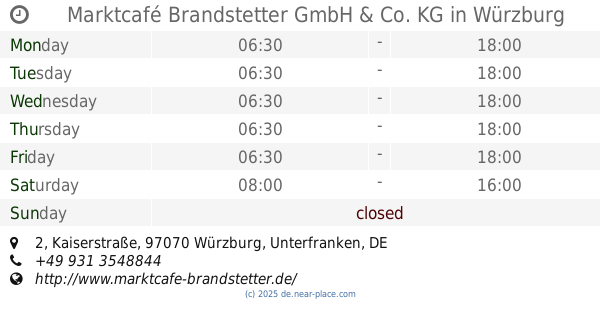
Marktcafé Brandstetter GmbH & Co. KG
Kaiserstraße 2, Würzburg
Bakery
Cafe
Food
Store
Point of interest
Establishment
read more
258 m
Kiliansbäck
Oberthürstraße 2-4, Würzburg
Bakery
Cafe
Point of interest
Food
Store
Establishment
read more
268 m
BB Rösner Backstube GmbH
Semmelstraße 41, Würzburg
Bakery
read more
337 m
The Yeah Box
Wilhelmstraße 5, Würzburg
Meal takeaway
Bakery
Restaurant
Store
Cafe
Point of interest
Food
Establishment
read more
351 m
BB Rösner Backstube GmbH
Ludwigstraße 1B, Würzburg
Bakery
read more
454 m
MÜLLERBÄCK oHG
Theaterstraße 22, Würzburg
Bakery
read more
558 m
Bassanese Cafe am Dom
Kürschnerhof 2, Würzburg
Cafe
Bakery
Restaurant
Point of interest
Food
Store
Establishment
read more
622 m
Kiliansbäck Bäckerei
Domstraße 7, Würzburg
Bakery
Cafe
Store
Food
Point of interest
Establishment
read more
862 m
MÜLLERBÄCK oHG
Schweinfurter Straße 6, Würzburg
Bakery
read more
945 m
Der Müllerbäck GmbH
Wagnerstraße 10, Würzburg
Bakery
read more
1.088 km
Bäckerei Weber Smart Shop
Geschwister-Scholl-Platz, Würzburg
Bakery
read more
1.097 km
Schiffer-Bäckerei GmbH
Rottendorfer Straße 9, Würzburg
Bakery
read more
1.097 km
Schiffer-Bäckerei GmbH
St.-Benedikt-Straße 10, Würzburg
Bakery
read more
1.839 km
Bäckerei Weber Inh. Peter Weber Bäckerei - Konditorei
Erthalstraße 38, Würzburg
Bakery
read more
1.857 km
Bäckerei Hanselmann
Erthalstraße 48, Würzburg
Bakery
read more
📑
all categories
Accounting
Administrative area level 1
Administrative area level 2
Airport
Amusement park
Aquarium
Art gallery
Atm
Bakery
Bank
Bar
Beauty salon
Bicycle store
Book store
Bowling alley
Bus station
Cafe
Campground
Car dealer
Car rental
Car repair
Car wash
Casino
Cemetery
Church
City hall
Clothing store
Colloquial area
Convenience store
Country
Courthouse
Dentist
Department store
Doctor
Electrician
Electronics store
Embassy
Establishment
Finance
Fire station
Florist
Food
Funeral home
Furniture store
Gas station
General contractor
Grocery or supermarket
Gym
Hair care
Hardware store
Health
Hindu Temple
Home goods store
Hospital
Insurance agency
Jewelry store
Laundry
Lawyer
Library
Light rail station
Liquor store
Local government office
Locality
Locksmith
Lodging
Meal delivery
Meal takeaway
Mosque
Movie rental
Movie theater
Moving company
Museum
Natural feature
Neighborhood
Night club
Painter
Park
Parking
Pet store
Pharmacy
Physiotherapist
Place of worship
Plumber
Point of interest
Police
Political
Post office
Premise
Real estate agency
Restaurant
Roofing contractor
Route
Rv park, camping
School
Shoe store
Shopping mall
Spa
Stadium
Storage
Store
Subpremise
Subway station
Supermarket
Synagogue
Taxi stand
Train station
Transit station
Travel agency
University
Veterinary care
Zoo
administrative area level 3
administrative area level 4
sublocality level 1
sublocality level 2
sublocality level 3
↑