Supermarket nearby Lidl
Coronavirus disease (COVID-19) Situation
confirmed cases
38828995
deaths
183027
Germany
Supermarket nearby Lidl
Lidl
7, Stadtheider Straße, 33609, Bielefeld, Detmold, DE Germany
contacts phone
:
+49 800 4353361
website:
www.lidl.de
Latitude:
52.037149
, Longitude:
8.552368
larger map & directions
read more
nearest Supermarket
41 m
Lidl
Stadtheider Straße 11, Bielefeld
Supermarket
read more
581 m
SPAR Express
Beckhausstraße 40, Bielefeld
Supermarket
read more
626 m
Mix Markt
Beckhausstraße 72, Bielefeld
Supermarket
read more
1.202 km
Netto
Beckhausstraße 129, Bielefeld
Supermarket
read more
1.361 km
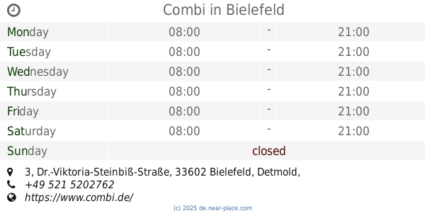
Combi
Dr.-Viktoria-Steinbiß-Straße 3, Bielefeld
Supermarket
read more
1.52 km
Schenke Delikatessen
Engersche Straße 96, Bielefeld
Supermarket
read more
1.554 km
Combi consumer market Bielefeld, Lohbreite
Lohbreite 7, Bielefeld
Supermarket
read more
1.554 km
Ditsch Bielefeld, Hauptbahnhof
Bahnhofstraße 1 b, Bielefeld
Supermarket
read more
1.632 km
Combi consumer market Bielefeld, corner Str.
Eckendorfer Straße 94, Bielefeld
Supermarket
read more
1.653 km
Asia Laden
Neumarkt 13, Bielefeld
Supermarket
read more
1.778 km
Netto
Heeper Straße 78, Bielefeld
Supermarket
read more
1.834 km
Lidl
Jöllenbecker Straße 41, Bielefeld
Supermarket
read more
1.864 km
dm-drogerie markt
Herforder Straße 9, Bielefeld
Supermarket
read more
1.881 km
DICLE MARKT
Wilhelmstraße 4, Bielefeld
Supermarket
read more
1.885 km
dm-drug store market
Bahnhofstraße 39, Bielefeld
Supermarket
read more
📑
all categories
Accounting
Administrative area level 1
Administrative area level 2
Airport
Amusement park
Aquarium
Art gallery
Atm
Bakery
Bank
Bar
Beauty salon
Bicycle store
Book store
Bowling alley
Bus station
Cafe
Campground
Car dealer
Car rental
Car repair
Car wash
Casino
Cemetery
Church
City hall
Clothing store
Colloquial area
Convenience store
Country
Courthouse
Dentist
Department store
Doctor
Electrician
Electronics store
Embassy
Establishment
Finance
Fire station
Florist
Food
Funeral home
Furniture store
Gas station
General contractor
Grocery or supermarket
Gym
Hair care
Hardware store
Health
Hindu Temple
Home goods store
Hospital
Insurance agency
Jewelry store
Laundry
Lawyer
Library
Light rail station
Liquor store
Local government office
Locality
Locksmith
Lodging
Meal delivery
Meal takeaway
Mosque
Movie rental
Movie theater
Moving company
Museum
Natural feature
Neighborhood
Night club
Painter
Park
Parking
Pet store
Pharmacy
Physiotherapist
Place of worship
Plumber
Point of interest
Police
Political
Post office
Premise
Real estate agency
Restaurant
Roofing contractor
Route
Rv park, camping
School
Shoe store
Shopping mall
Spa
Stadium
Storage
Store
Subpremise
Subway station
Supermarket
Synagogue
Taxi stand
Train station
Transit station
Travel agency
University
Veterinary care
Zoo
administrative area level 3
administrative area level 4
sublocality level 1
sublocality level 2
sublocality level 3
↑