Supermarket nearby Krach
Coronavirus disease (COVID-19) Situation
confirmed cases
38828995
deaths
183027
Germany
Supermarket nearby Krach
Krach
Lärchenstraße 9, Steinhagen Alemania
contacts phone
:
+49
Latitude:
52.02391
, Longitude:
8.42273
read more
nearest Supermarket
403 m
Aldi
Bahnhofstraße 25, Steinhagen
Supermarket
read more
1.77 km
ALDI Steinhagen
Bahnhofstraße 25, Steinhagen
Supermarket
read more
1.865 km
Lidl
Bahnhofstraße 23, Steinhagen
Supermarket
read more
1.94 km
SPAR Express
Brackweder Straße 53a, Halle In Westfalen
Supermarket
read more
1.971 km
EDEKA Nolte
Mühlenstraße 2, Steinhagen
Supermarket
read more
2.391 km
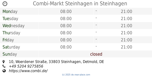
Combi-Markt Steinhagen
Woerdener Straße 10, Steinhagen
Supermarket
Grocery or supermarket
Home goods store
Food
Point of interest
Store
Establishment
read more
3.542 km
Combi consumer market Bielefeld, Dornberg
Wertherstraße 431, Bielefeld
Supermarket
read more
3.542 km
Jibi Markt Filiale Bielefeld Dornberg
Wertherstraße 431, Bielefeld
Supermarket
read more
4.485 km
Combi Verbrauchermarkt Bielefeld, Werther Str. 266
Wertherstraße 266, Bielefeld
Supermarket
read more
4.909 km
PENNY-Markt Discounter
Kreuzberger Straße 19, Bielefeld
Supermarket
read more
5.257 km
Edeka ... fresh at Böers
Carl-Severing-Straße 91, Bielefeld
Supermarket
read more
5.296 km
ALDI Bielefeld-Quelle
Carl-Severing-Straße 85, Bielefeld
Supermarket
read more
5.91 km
real
Gütersloher Straße 122, Bielefeld
Supermarket
Grocery or supermarket
Food
Point of interest
Store
Establishment
read more
5.937 km
Kaufland
Gütersloher Straße 122, Bielefeld
Supermarket
Grocery or supermarket
Food
Store
Point of interest
Establishment
read more
6.155 km
ALDI Bielefeld-Brackwede
Gütersloher Straße 243, Bielefeld
Supermarket
read more
📑
all categories
Accounting
Administrative area level 1
Administrative area level 2
Airport
Amusement park
Aquarium
Art gallery
Atm
Bakery
Bank
Bar
Beauty salon
Bicycle store
Book store
Bowling alley
Bus station
Cafe
Campground
Car dealer
Car rental
Car repair
Car wash
Casino
Cemetery
Church
City hall
Clothing store
Colloquial area
Convenience store
Country
Courthouse
Dentist
Department store
Doctor
Electrician
Electronics store
Embassy
Establishment
Finance
Fire station
Florist
Food
Funeral home
Furniture store
Gas station
General contractor
Grocery or supermarket
Gym
Hair care
Hardware store
Health
Hindu Temple
Home goods store
Hospital
Insurance agency
Jewelry store
Laundry
Lawyer
Library
Light rail station
Liquor store
Local government office
Locality
Locksmith
Lodging
Meal delivery
Meal takeaway
Mosque
Movie rental
Movie theater
Moving company
Museum
Natural feature
Neighborhood
Night club
Painter
Park
Parking
Pet store
Pharmacy
Physiotherapist
Place of worship
Plumber
Point of interest
Police
Political
Post office
Premise
Real estate agency
Restaurant
Roofing contractor
Route
Rv park, camping
School
Shoe store
Shopping mall
Spa
Stadium
Storage
Store
Subpremise
Subway station
Supermarket
Synagogue
Taxi stand
Train station
Transit station
Travel agency
University
Veterinary care
Zoo
administrative area level 3
administrative area level 4
sublocality level 1
sublocality level 2
sublocality level 3
↑