Supermarket nearby Joya's
Coronavirus disease (COVID-19) Situation
confirmed cases
38828995
deaths
183027
Germany
Supermarket nearby Joya's
Joya's
Mittlere Bleiche 9, Mainz Tyskland
contacts phone
:
+49
Latitude:
50.001198
, Longitude:
8.263985
read more
nearest Supermarket
25 m
Günay's Supermarkt
Mittlere Bleiche 9 - 11, Mainz
Supermarket
read more
25 m
Günay's Supermarkt
Mittlere Bleiche 11, Mainz
Supermarket
read more
92 m
REWE City
Große Bleiche 14-18, Mainz
Supermarket
read more
92 m
REWE
Große Bleiche 14-18, Mainz
Supermarket
read more
126 m
dm-drogerie markt
Große Bleiche 14-16, Mainz
Supermarket
read more
205 m
Tegut... gute Lebensmittel GmbH & Co.KG
Bahnhofstraße 8A, Mainz
Supermarket
read more
205 m
tegut
Bahnhofstraße 8A, Mainz
Supermarket
read more
208 m
dm-drogerie markt
Lotharstraße 11-13, Mainz
Supermarket
read more
301 m
REWE
Mittlere Bleiche 53-57, Mainz
Supermarket
read more
303 m
Netto Marken-Discount
Adolf-Kolping-Straße 2, Mainz
Supermarket
read more
308 m
Lidl
Große Bleiche 41-45, Mainz
Supermarket
read more
379 m
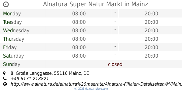
Alnatura Super Natur Markt
Große Langgasse 8, Mainz
Supermarket
read more
400 m
REWE City
Am Kronberger Hof 1, Mainz
Supermarket
read more
472 m
dm-drogerie markt
Seppel-Glückert-Passage 10, Mainz
Supermarket
read more
506 m
PENNY-Markt Discounter
Boppstraße 11, Mainz
Supermarket
read more
543 m
dm-drogerie markt
Ludwigsstraße 11, Mainz
Supermarket
read more
574 m
أسواق بغداد
Kaiser-Wilhelm-Ring 28, Mainz
Supermarket
read more
612 m
Netto Marken-Discount City
Drususstraße 3, Mainz
Supermarket
read more
612 m
Netto
Drususstraße 3, Mainz
Supermarket
read more
698 m
REWE
Adam-Karrillon-Straße 23A, Mainz
Supermarket
read more
698 m
REWE City
Adam-Karrillon-Straße 23A, Mainz
Supermarket
read more
701 m
Babylon Mini Markt Kiosk
Hindenburgstraße 18, Mainz
Supermarket
read more
821 m
REWE City
Nackstraße 31-33, Mainz
Supermarket
read more
822 m
Mainz Market
Kaiser-Wilhelm-Ring 68, Mainz
Supermarket
read more
1.175 km
tegut
Holzhofstraße 9, Mainz
Supermarket
read more
📑
all categories
Accounting
Administrative area level 1
Administrative area level 2
Airport
Amusement park
Aquarium
Art gallery
Atm
Bakery
Bank
Bar
Beauty salon
Bicycle store
Book store
Bowling alley
Bus station
Cafe
Campground
Car dealer
Car rental
Car repair
Car wash
Casino
Cemetery
Church
City hall
Clothing store
Colloquial area
Convenience store
Country
Courthouse
Dentist
Department store
Doctor
Electrician
Electronics store
Embassy
Establishment
Finance
Fire station
Florist
Food
Funeral home
Furniture store
Gas station
General contractor
Grocery or supermarket
Gym
Hair care
Hardware store
Health
Hindu Temple
Home goods store
Hospital
Insurance agency
Jewelry store
Laundry
Lawyer
Library
Light rail station
Liquor store
Local government office
Locality
Locksmith
Lodging
Meal delivery
Meal takeaway
Mosque
Movie rental
Movie theater
Moving company
Museum
Natural feature
Neighborhood
Night club
Painter
Park
Parking
Pet store
Pharmacy
Physiotherapist
Place of worship
Plumber
Point of interest
Police
Political
Post office
Premise
Real estate agency
Restaurant
Roofing contractor
Route
Rv park, camping
School
Shoe store
Shopping mall
Spa
Stadium
Storage
Store
Subpremise
Subway station
Supermarket
Synagogue
Taxi stand
Train station
Transit station
Travel agency
University
Veterinary care
Zoo
administrative area level 3
administrative area level 4
sublocality level 1
sublocality level 2
sublocality level 3
↑