Restaurant nearby Heiliggeist
Coronavirus disease (COVID-19) Situation
confirmed cases
38828995
deaths
183027
Germany
Restaurant nearby Heiliggeist
Heiliggeist
Rentengasse 2, Mainz Tyskland
contacts phone
:
+49
Latitude:
50.00027
, Longitude:
8.27594
read more
nearest Restaurant
91 m
placetobee-gastro GmbH
Liebfrauenstraße 5, Mainz
Restaurant
read more
164 m
Ghost Gastro GmbH
Lauterenstraße 37, Mainz
Restaurant
read more
216 m
Ali-Kamer Gündogan Imbiss Big Pom
Am Brand 2, Mainz
Restaurant
read more
326 m
Weinhaus Zum Spiegel
Leichhof 1, Mainz
Restaurant
read more
335 m
Parking Centro
Karmeliterstraße 6, Mainz
Restaurant
read more
341 m
eatDOORI
Augustinerstraße 54-56, Mainz
Restaurant
read more
366 m
Thai Style
Schusterstraße 58, Mainz
Restaurant
read more
479 m
Heiliger Elch · Dahoud & Seefried GbR
Dominikanerstraße 2, Mainz
Restaurant
read more
503 m
Hachem Eljajieh
Emmeransstraße 35, Mainz
Restaurant
read more
526 m
Oma Else
Jakobsbergstraße 12, Mainz
Restaurant
read more
584 m
Caislean Gaststättenbetriebs- und -einrichtungs GmbH
Weißliliengasse 5, Mainz
Restaurant
read more
645 m
WeinHerbst & WeinFrühling am Schillerplatz
Schillerplatz, Mainz
Restaurant
read more
666 m
Niko Niko Tei
Gaustraße 67, Mainz
Restaurant
read more
668 m
Sushi Bar
Steingasse 13, Mainz
Restaurant
read more
673 m
Citrus
Rheinstraße 2, Mainz
Restaurant
read more
721 m
Happy Sumo
Holzhofstraße 5, Mainz
Restaurant
read more
765 m
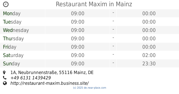
Restaurant Maxim
Neubrunnenstraße 1A, Mainz
Restaurant
read more
771 m
Thai Style
Neubrunnenstraße 3, Mainz
Restaurant
read more
787 m
Altstadt
Gaustraße 27, Mainz
Restaurant
read more
817 m
Bengal Tandoori
Mittlere Bleiche 25, Mainz
Restaurant
read more
895 m
Casa Algarve
Hintere Bleiche 25, Mainz
Restaurant
read more
933 m
Taormina
Bilhildisstraße 4, Mainz
Restaurant
read more
965 m
Lalo Bistro
Bahnhofstraße 2b, Mainz
Restaurant
read more
1.009 km
Restaurante Da Fabio
Krauseneckstraße 11, Wiesbaden
Restaurant
read more
1.152 km
BISTRO UG
Adam-Karrillon-Straße 23, Mainz
Restaurant
read more
📑
all categories
Accounting
Administrative area level 1
Administrative area level 2
Airport
Amusement park
Aquarium
Art gallery
Atm
Bakery
Bank
Bar
Beauty salon
Bicycle store
Book store
Bowling alley
Bus station
Cafe
Campground
Car dealer
Car rental
Car repair
Car wash
Casino
Cemetery
Church
City hall
Clothing store
Colloquial area
Convenience store
Country
Courthouse
Dentist
Department store
Doctor
Electrician
Electronics store
Embassy
Establishment
Finance
Fire station
Florist
Food
Funeral home
Furniture store
Gas station
General contractor
Grocery or supermarket
Gym
Hair care
Hardware store
Health
Hindu Temple
Home goods store
Hospital
Insurance agency
Jewelry store
Laundry
Lawyer
Library
Light rail station
Liquor store
Local government office
Locality
Locksmith
Lodging
Meal delivery
Meal takeaway
Mosque
Movie rental
Movie theater
Moving company
Museum
Natural feature
Neighborhood
Night club
Painter
Park
Parking
Pet store
Pharmacy
Physiotherapist
Place of worship
Plumber
Point of interest
Police
Political
Post office
Premise
Real estate agency
Restaurant
Roofing contractor
Route
Rv park, camping
School
Shoe store
Shopping mall
Spa
Stadium
Storage
Store
Subpremise
Subway station
Supermarket
Synagogue
Taxi stand
Train station
Transit station
Travel agency
University
Veterinary care
Zoo
administrative area level 3
administrative area level 4
sublocality level 1
sublocality level 2
sublocality level 3
↑