Restaurant nearby Gaststätte Reiterstübchen
Coronavirus disease (COVID-19) Situation
confirmed cases
38828995
deaths
183027
Germany
Restaurant nearby Gaststätte Reiterstübchen
Gaststätte Reiterstübchen
Alleestraße 8, Hamm Deutschland
contacts phone
:
+49
Latitude:
51.67182
, Longitude:
7.8242
read more
nearest Restaurant
181 m
Pizza King's Hamm
Werlerstraße 91, Hamm
Restaurant
read more
243 m
Pizzeria MIAMI
Werler Straße 52, Hamm
Restaurant
read more
294 m
Fußball-Kneipenquiz im Roetger's
Werler Straße 33, Hamm
Restaurant
read more
366 m
Restaurante Da Enzo
Werler Straße 32, Hamm
Restaurant
read more
515 m
Hammer Tafelfreuden
Werler Straße 3, Hamm
Restaurant
read more
534 m
Pizzeria al Forno
Grünstraße 6, Hamm
Restaurant
read more
748 m
Kaminklause
Albertstraße 54, Hamm
Restaurant
read more
766 m
Sedan-Eck
Sedanstraße 28, Hamm
Restaurant
read more
793 m
Pizzeria Sicilia
Roonstraße 59, Hamm
Restaurant
read more
807 m
Pizzeria Fax
Sedanstraße 15, Hamm
Restaurant
read more
817 m
Paki Döner Pizza
Caldenhofer Weg 88, Hamm
Restaurant
read more
818 m
Nazar Döner
Caldenhofer Weg 88, Hamm
Restaurant
read more
878 m
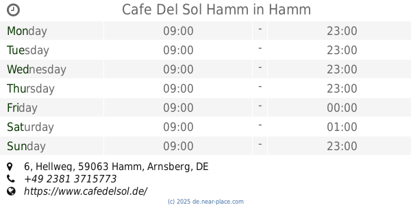
Cafe Del Sol Hamm
Hellweg 6, Hamm
Restaurant
read more
951 m
Lotus Bistro China-Thai Food
Chattanoogaplatz 1, Hamm
Restaurant
read more
1.001 km
Erciyes Pide/Pizza/Döner
Südstraße 7, Hamm
Restaurant
read more
1.018 km
EFES Grill bei Usta
Südstraße 3, Hamm
Restaurant
read more
1.115 km
Enchilada Hamm
Martin-Luther-Straße 31, Hamm
Restaurant
read more
1.122 km
Deniz Imbiss
Bahnhofstraße 31, Hamm
Restaurant
read more
1.138 km
Star Döner
19 Bahnhofstraße, Hamm
Restaurant
read more
1.188 km
Chicken Time Bei Al Scham
Westentor 4, Hamm
Restaurant
read more
1.194 km
Magic Waffel
Bahnhofstraße 2, Hamm
Restaurant
read more
1.195 km
Restaurant ISENBECK DEELE
Willy-Brandt-Platz 7, Hamm
Restaurant
read more
1.195 km
Isenbeck-Deele
Willy-Brandt-Platz 7, Hamm
Restaurant
read more
1.203 km
Cigköftem Hamm
Westring 2, Hamm
Restaurant
read more
1.32 km
Asia WOK
Hamm
Restaurant
read more
📑
all categories
Accounting
Administrative area level 1
Administrative area level 2
Airport
Amusement park
Aquarium
Art gallery
Atm
Bakery
Bank
Bar
Beauty salon
Bicycle store
Book store
Bowling alley
Bus station
Cafe
Campground
Car dealer
Car rental
Car repair
Car wash
Casino
Cemetery
Church
City hall
Clothing store
Colloquial area
Convenience store
Country
Courthouse
Dentist
Department store
Doctor
Electrician
Electronics store
Embassy
Establishment
Finance
Fire station
Florist
Food
Funeral home
Furniture store
Gas station
General contractor
Grocery or supermarket
Gym
Hair care
Hardware store
Health
Hindu Temple
Home goods store
Hospital
Insurance agency
Jewelry store
Laundry
Lawyer
Library
Light rail station
Liquor store
Local government office
Locality
Locksmith
Lodging
Meal delivery
Meal takeaway
Mosque
Movie rental
Movie theater
Moving company
Museum
Natural feature
Neighborhood
Night club
Painter
Park
Parking
Pet store
Pharmacy
Physiotherapist
Place of worship
Plumber
Point of interest
Police
Political
Post office
Premise
Real estate agency
Restaurant
Roofing contractor
Route
Rv park, camping
School
Shoe store
Shopping mall
Spa
Stadium
Storage
Store
Subpremise
Subway station
Supermarket
Synagogue
Taxi stand
Train station
Transit station
Travel agency
University
Veterinary care
Zoo
administrative area level 3
administrative area level 4
sublocality level 1
sublocality level 2
sublocality level 3
↑