Premise nearby Breslauer Str. 52
Coronavirus disease (COVID-19) Situation
confirmed cases
38828995
deaths
183027
Germany
Premise nearby Breslauer Str. 52
Breslauer Str. 52
Weinheim Alemania
contacts phone
:
+49
Latitude:
49.5429918
, Longitude:
8.6476356
read more
nearest Premise
1000 m
Parkplatz Miramar
Ofling
Premise
read more
1.804 km
Teiche am Landgraben
Weinheim
Premise
read more
7.93 km
Magdeburger Str. 1
Mannheim
Premise
read more
10.239 km
Unterer Neckar: Neckaraue zwischen Botzheimer Wasen und Obere Wörth
Ladenburg
Premise
read more
11.331 km
Skatepark Mannheim Seckenheim
Seckenheim
Premise
read more
12.143 km
Rudi-Baerwind-Platz
Mannheim
Premise
read more
12.27 km
Unterer Neckar: Maulbeerinsel
Mannheim
Premise
read more
13.451 km
Kleingärtnerverein Mannheim-Friedrichsfeld eingetragener Verein
Friedrichsfeld
Premise
read more
13.805 km
Studentenwohnheim
Handschuhsheimer Feld
Premise
read more
13.865 km
Parkhaus Im Neuenheimer Feld
Handschuhsheimer Feld
Premise
read more
14.169 km
O7 18A
Quadrate
Premise
read more
14.392 km
WISAG Gebäude- und Industrieservice Süd-West GmbH & Co. KG
Ohmweg 11, Mannheim
Premise
read more
14.781 km
Zeughaus
Quadrate
Premise
read more
14.985 km
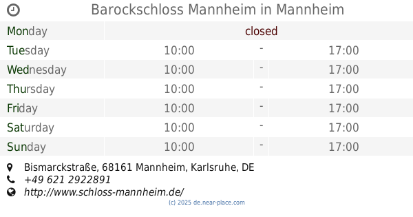
Barockschloss Mannheim
Bismarckstraße, Mannheim
Premise
read more
15.078 km
Schnickenlock
Lindenhof
Premise
read more
15.092 km
Old Bridge Gate
Heidelberg
Premise
read more
15.463 km
Bolzplatz
Neckarau
Premise
read more
15.731 km
Kurt-Schumacher-Brücke
Mannheim
Premise
read more
16.096 km
Rathauspl. 20
Mitte
Premise
read more
16.808 km
Bezirkstraße 16
Altrip
Premise
read more
17.299 km
Backofen-Riedwiesen
Tyskland
Premise
read more
17.364 km
Horreninsel
Altrip
Premise
read more
19.023 km
Neuhofener Altrhein
Germany
Premise
read more
19.574 km
Kistnerweiher
Neuhofen
Premise
read more
20.178 km
Beachvolleyballfeld Schlicht
Neuhofen
Premise
read more
📑
all categories
Accounting
Administrative area level 1
Administrative area level 2
Airport
Amusement park
Aquarium
Art gallery
Atm
Bakery
Bank
Bar
Beauty salon
Bicycle store
Book store
Bowling alley
Bus station
Cafe
Campground
Car dealer
Car rental
Car repair
Car wash
Casino
Cemetery
Church
City hall
Clothing store
Colloquial area
Convenience store
Country
Courthouse
Dentist
Department store
Doctor
Electrician
Electronics store
Embassy
Establishment
Finance
Fire station
Florist
Food
Funeral home
Furniture store
Gas station
General contractor
Grocery or supermarket
Gym
Hair care
Hardware store
Health
Hindu Temple
Home goods store
Hospital
Insurance agency
Jewelry store
Laundry
Lawyer
Library
Light rail station
Liquor store
Local government office
Locality
Locksmith
Lodging
Meal delivery
Meal takeaway
Mosque
Movie rental
Movie theater
Moving company
Museum
Natural feature
Neighborhood
Night club
Painter
Park
Parking
Pet store
Pharmacy
Physiotherapist
Place of worship
Plumber
Point of interest
Police
Political
Post office
Premise
Real estate agency
Restaurant
Roofing contractor
Route
Rv park, camping
School
Shoe store
Shopping mall
Spa
Stadium
Storage
Store
Subpremise
Subway station
Supermarket
Synagogue
Taxi stand
Train station
Transit station
Travel agency
University
Veterinary care
Zoo
administrative area level 3
administrative area level 4
sublocality level 1
sublocality level 2
sublocality level 3
↑