Police nearby Bezirksdienst Niederkassel
Coronavirus disease (COVID-19) Situation
confirmed cases
38828995
deaths
183027
Germany
Police nearby Bezirksdienst Niederkassel
Bezirksdienst Niederkassel
Rathausstraße 19, Niederkassel Germany
contacts phone
:
+49
Latitude:
50.8125565
, Longitude:
7.0347758
read more
nearest Police
14 m
Polizei Niederkassel
Rathausstraße 19, Niederkassel
Police
read more
6.408 km
Polizeiwache Bornheim
Peter-Fryns-Platz 4, Bornheim
Police
read more
7.056 km
Polizeianlaufst. Tannenbusch
Oppelner Straße 55, Bonn
Police
read more
8.353 km
Polizeiwache Troisdorf
Poststraße 65, Troisdorf
Police
read more
9.809 km
Autobahnpolizeiwache St. Augustin
Am Bauhof 6, Sankt Augustin
Police
read more
9.832 km
GABI Gemeinsame Anlaufstelle Bonner Innenstadt
Maximilianstraße 32, Bonn
Police
read more
9.931 km
Wasserschutzpolizei Bonn
Rheinaustraße 132, Bonn
Police
read more
9.995 km
BPOLD STA
Bundesgrenzschutzstraße 100, Sankt Augustin
Police
read more
10.39 km
Bundespolizeidirektion Sankt Augustin
Bundesgrenzschutzstraße 100, Sankt Augustin
Police
read more
10.429 km
IPA GmbH Köln
Jägerstraße 8, Köln
Police
read more
10.721 km
Polizeianlaufstelle Poppelsdorf
Sebastianstraße 15, Bonn
Police
read more
11.184 km
Polizeiwache Duisdorf
Villemombler Straße 77, Bonn
Police
read more
11.266 km
Police Station Sankt Augustin
Rathausallee 2, Sankt Augustin
Police
read more
11.298 km
Brodala Gruppe
Lotharstraße 21, Bonn
Police
read more
12.393 km
Kriminalpolizei Hürth
Hans-Böckler-Straße 21, Hürth
Police
read more
12.572 km
Polizeidienststelle Hürth
Luxemburger Straße 303A, Hürth
Police
read more
13.06 km
Polizei Bezirksdienststelle Lohmar
Hauptstraße 25, Lohmar
Police
read more
13.243 km
Polizeiwache Sülz
Rhöndorfer Straße 16, Köln
Police
read more
13.372 km
Polizeiwache Deutz
Siegburger Straße 195A, Köln
Police
read more
13.404 km
Wasserschutzpolizei-Wache Duisburg (Standort Köln)
Alfred-Schütte-Allee 2-4, Köln
Police
read more
13.404 km
Water Police guard Duisburg (Cologne)
Alfred-Schütte-Allee 2-4, Köln
Police
read more
14.172 km
Polizei Nordrhein-Westfalen
Walter-Pauli-Ring 2-6, Köln
Police
read more
15.431 km
Bundespolizeiinspektion Köln
Marzellenstraße 3-5, Köln
Police
read more
15.709 km
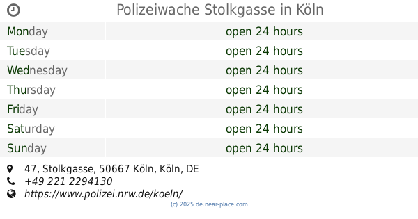
Polizeiwache Stolkgasse
Stolkgasse 47, Köln
Police
read more
20.131 km
Polizeiwache Weiden
Aachener Straße 1274, Köln
Police
read more
📑
all categories
Accounting
Administrative area level 1
Administrative area level 2
Airport
Amusement park
Aquarium
Art gallery
Atm
Bakery
Bank
Bar
Beauty salon
Bicycle store
Book store
Bowling alley
Bus station
Cafe
Campground
Car dealer
Car rental
Car repair
Car wash
Casino
Cemetery
Church
City hall
Clothing store
Colloquial area
Convenience store
Country
Courthouse
Dentist
Department store
Doctor
Electrician
Electronics store
Embassy
Establishment
Finance
Fire station
Florist
Food
Funeral home
Furniture store
Gas station
General contractor
Grocery or supermarket
Gym
Hair care
Hardware store
Health
Hindu Temple
Home goods store
Hospital
Insurance agency
Jewelry store
Laundry
Lawyer
Library
Light rail station
Liquor store
Local government office
Locality
Locksmith
Lodging
Meal delivery
Meal takeaway
Mosque
Movie rental
Movie theater
Moving company
Museum
Natural feature
Neighborhood
Night club
Painter
Park
Parking
Pet store
Pharmacy
Physiotherapist
Place of worship
Plumber
Point of interest
Police
Political
Post office
Premise
Real estate agency
Restaurant
Roofing contractor
Route
Rv park, camping
School
Shoe store
Shopping mall
Spa
Stadium
Storage
Store
Subpremise
Subway station
Supermarket
Synagogue
Taxi stand
Train station
Transit station
Travel agency
University
Veterinary care
Zoo
administrative area level 3
administrative area level 4
sublocality level 1
sublocality level 2
sublocality level 3
↑