Pharmacy nearby easyApotheke Mariendorf
Coronavirus disease (COVID-19) Situation
confirmed cases
38828995
deaths
183027
Germany
Pharmacy nearby easyApotheke Mariendorf
easyApotheke Mariendorf
Großbeerenstraße 2, Berlin Deutschland
contacts phone
:
+49
Latitude:
52.4388286
, Longitude:
13.3801002
read more
nearest Pharmacy
63 m
Heike Ebert, Apothekerin, e. K.
Großbeerenstraße 2, Berlin
Pharmacy
read more
628 m
Fritz-Apotheke
Mariendorfer Damm 165, Berlin
Pharmacy
read more
802 m
Markt Apotheke
Mariendorfer Damm 84, Berlin
Pharmacy
read more
934 m
Fortunatus Apotheke
Mariendorfer Damm 68, Berlin
Pharmacy
read more
1.496 km
Sertürner Apotheke
Wedellstraße 37, Berlin
Pharmacy
read more
1.903 km
Konradin-Apotheke
Friedrich-Karl-Straße 23, Berlin
Pharmacy
read more
1.951 km
Arcaden Apotheke
Tempelhofer Damm 227, Berlin
Pharmacy
read more
1.993 km
Wittekind-Apotheke am Attilaplatz
Manteuffelstraße 32, Berlin
Pharmacy
read more
2.043 km
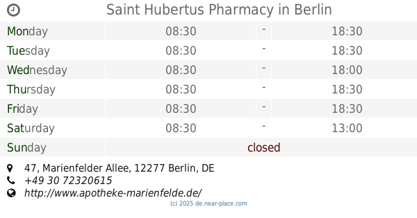
Saint Hubertus Pharmacy
Marienfelder Allee 47, Berlin
Pharmacy
read more
2.043 km
Sankt Hubertus Apotheke
Marienfelder Allee 47, Berlin
Pharmacy
read more
2.083 km
Tauern-Apotheke
Albulaweg 29, Berlin
Pharmacy
read more
2.299 km
Thalia Apotheke
Kaiser-Wilhelm-Straße 81, Berlin
Pharmacy
read more
2.479 km
Südend Apotheke
Steglitzer Damm 68, Berlin
Pharmacy
read more
2.485 km
Südend-Apotheke Apotheker Peter Schweigert e. Kfm.
Steglitzer Damm 68, Berlin
Pharmacy
read more
2.741 km
Grosscurths Apotheke
Siemensstraße 2, Berlin
Pharmacy
read more
📑
all categories
Accounting
Administrative area level 1
Administrative area level 2
Airport
Amusement park
Aquarium
Art gallery
Atm
Bakery
Bank
Bar
Beauty salon
Bicycle store
Book store
Bowling alley
Bus station
Cafe
Campground
Car dealer
Car rental
Car repair
Car wash
Casino
Cemetery
Church
City hall
Clothing store
Colloquial area
Convenience store
Country
Courthouse
Dentist
Department store
Doctor
Electrician
Electronics store
Embassy
Establishment
Finance
Fire station
Florist
Food
Funeral home
Furniture store
Gas station
General contractor
Grocery or supermarket
Gym
Hair care
Hardware store
Health
Hindu Temple
Home goods store
Hospital
Insurance agency
Jewelry store
Laundry
Lawyer
Library
Light rail station
Liquor store
Local government office
Locality
Locksmith
Lodging
Meal delivery
Meal takeaway
Mosque
Movie rental
Movie theater
Moving company
Museum
Natural feature
Neighborhood
Night club
Painter
Park
Parking
Pet store
Pharmacy
Physiotherapist
Place of worship
Plumber
Point of interest
Police
Political
Post office
Premise
Real estate agency
Restaurant
Roofing contractor
Route
Rv park, camping
School
Shoe store
Shopping mall
Spa
Stadium
Storage
Store
Subpremise
Subway station
Supermarket
Synagogue
Taxi stand
Train station
Transit station
Travel agency
University
Veterinary care
Zoo
administrative area level 3
administrative area level 4
sublocality level 1
sublocality level 2
sublocality level 3
↑