Pharmacy nearby Apotheke an der Oper
Coronavirus disease (COVID-19) Situation
confirmed cases
38828995
deaths
183027
Germany
Pharmacy nearby Apotheke an der Oper
Apotheke an der Oper
Breite Straße 29, Köln Deutschland
contacts phone
:
+49
Latitude:
50.9388946
, Longitude:
6.9518757
read more
nearest Pharmacy
346 m
Apotheke am Neumarkt
Neumarkt 2, Köln
Pharmacy
read more
458 m
Apotheke im Haubrichforum
Haubrichforum, Josef-Haubrich-Hof 5, Köln
Pharmacy
read more
458 m
Pharmacy in Haubrichforum
Haubrichforum, Josef-Haubrich-Hof 5, Köln
Pharmacy
read more
527 m
Dom Apotheke Köln
Bahnhofsvorplatz 1, Köln
Pharmacy
read more
572 m
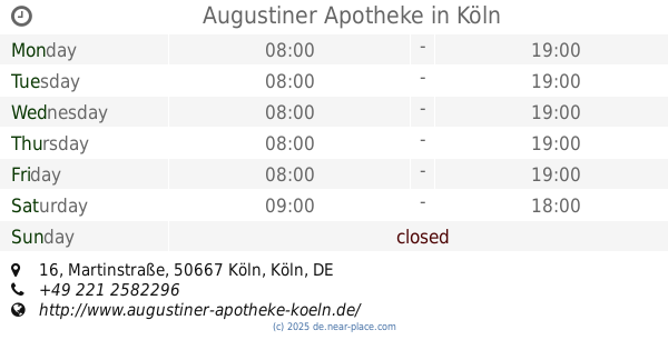
Augustiner-Apotheke
Martinstraße 16-20, Köln
Pharmacy
read more
576 m
Augustiner Apotheke
Martinstraße 16, Köln
Pharmacy
read more
702 m
Apotheke im Hauptbahnhof
Trankgasse 11, Köln
Pharmacy
read more
858 m
Hohenzollern Apotheke
Hohenzollernring 26, Köln
Pharmacy
read more
870 m
Christoph-Apotheke
Kaiser-Wilhelm-Ring 36, Köln
Pharmacy
read more
978 m
Westgate-Apotheke
Habsburgerring 2, Köln
Pharmacy
read more
981 m
Apotheke Friesenplatz 17
Friesenplatz 17, Köln
Pharmacy
read more
994 m
Viktoria-Apotheke
Aachener Straße 6, Köln
Pharmacy
read more
1.032 km
Birken-Apotheke
Hohenstaufenring 59, Köln
Pharmacy
read more
1.069 km
Merlin Apotheke
Richard-Wagner-Straße 9-11, Köln
Pharmacy
read more
1.191 km
Eschen-Apotheke am Zülpicher Platz
Zülpicher Platz 2, Köln
Pharmacy
read more
📑
all categories
Accounting
Administrative area level 1
Administrative area level 2
Airport
Amusement park
Aquarium
Art gallery
Atm
Bakery
Bank
Bar
Beauty salon
Bicycle store
Book store
Bowling alley
Bus station
Cafe
Campground
Car dealer
Car rental
Car repair
Car wash
Casino
Cemetery
Church
City hall
Clothing store
Colloquial area
Convenience store
Country
Courthouse
Dentist
Department store
Doctor
Electrician
Electronics store
Embassy
Establishment
Finance
Fire station
Florist
Food
Funeral home
Furniture store
Gas station
General contractor
Grocery or supermarket
Gym
Hair care
Hardware store
Health
Hindu Temple
Home goods store
Hospital
Insurance agency
Jewelry store
Laundry
Lawyer
Library
Light rail station
Liquor store
Local government office
Locality
Locksmith
Lodging
Meal delivery
Meal takeaway
Mosque
Movie rental
Movie theater
Moving company
Museum
Natural feature
Neighborhood
Night club
Painter
Park
Parking
Pet store
Pharmacy
Physiotherapist
Place of worship
Plumber
Point of interest
Police
Political
Post office
Premise
Real estate agency
Restaurant
Roofing contractor
Route
Rv park, camping
School
Shoe store
Shopping mall
Spa
Stadium
Storage
Store
Subpremise
Subway station
Supermarket
Synagogue
Taxi stand
Train station
Transit station
Travel agency
University
Veterinary care
Zoo
administrative area level 3
administrative area level 4
sublocality level 1
sublocality level 2
sublocality level 3
↑