Night club nearby Tanzfabrik Remscheid
Coronavirus disease (COVID-19) Situation
confirmed cases
38828995
deaths
183027
Germany
Night club nearby Tanzfabrik Remscheid
Tanzfabrik Remscheid
Nordstraße 27, Remscheid Alemania
contacts phone
:
+49
Latitude:
51.181093
, Longitude:
7.1994221
read more
nearest Night club
72 m
Sprung
Nordstraße, Remscheid
Night club
read more
387 m
Cafe Bar Restaurant Bar Beya
Markt 6a, Remscheid
Night club
read more
2.209 km
Timmis Castle
Intzestraße 78-98, Remscheid
Night club
read more
3.156 km
Diskothek Déjà-vu
Lenhartzhammer 4, Remscheid
Night club
read more
3.326 km
Pearl Club
Solinger Straße 134, Remscheid
Night club
read more
3.326 km
Club Champain
Solinger Straße 134, Remscheid
Night club
read more
3.654 km
Club Champain
Solinger Straße, Remscheid
Night club
read more
5.546 km
TOLLIRED CLUBBING
Location, TOLLIRED, Hans-Potyka-Straße 2-18, Remscheid
Night club
read more
7.971 km
Vibes dance & events
Hauptstraße 90, Solingen
Night club
read more
7.983 km
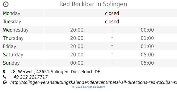
Red Rockbar
Werwolf 28, Solingen
Night club
read more
8.066 km
beatbar butze
Birkenweiher 27, Solingen
Night club
read more
9.082 km
Number One Karaoke Bar
Mühlenschütt 4, Wuppertal
Night club
read more
9.191 km
kitchenklub GmbH&Co.KG
Aue 10, Wuppertal
Night club
read more
9.283 km
Uclub
Kabelstraße 2, Wuppertal
Night club
read more
9.284 km
U-Club
Friedrich-Ebert-Straße 191, Wuppertal
Night club
read more
9.535 km
Bladi Orientlounge
Klotzbahn 11, Wuppertal
Night club
read more
10.049 km
Boogie-Friends-NRW
Breite Straße 7, Solingen
Night club
read more
10.263 km
DA F.U.N.K. Hip Hop Streetdance Kurse in Wuppertal
SPORTCENTER RAUENTAL GbR, Badische Straße 70, Wuppertal
Night club
read more
10.282 km
2000 and Great
Auf der Bleiche, Wuppertal
Night club
read more
11.074 km
Paffenlöher Steffi
Paffenlöh 7, Burscheid
Night club
read more
11.883 km
Wurzelhausen
51399, Unnamed Road, Burscheid
Night club
read more
13.366 km
SoundBude-FM Studio Leverkusen
Burscheider Straße 525, Leverkusen
Night club
read more
17.686 km
Pfadfinderstamm Hagen von Tronje e.V.
Holzer Weg 43F, Leverkusen
Night club
read more
20.55 km
Pigalle
Hardenbergstraße 45, Leverkusen
Night club
read more
20.55 km
Swinger Oase
Hardenbergstraße 45, Leverkusen
Night club
read more
📑
all categories
Accounting
Administrative area level 1
Administrative area level 2
Airport
Amusement park
Aquarium
Art gallery
Atm
Bakery
Bank
Bar
Beauty salon
Bicycle store
Book store
Bowling alley
Bus station
Cafe
Campground
Car dealer
Car rental
Car repair
Car wash
Casino
Cemetery
Church
City hall
Clothing store
Colloquial area
Convenience store
Country
Courthouse
Dentist
Department store
Doctor
Electrician
Electronics store
Embassy
Establishment
Finance
Fire station
Florist
Food
Funeral home
Furniture store
Gas station
General contractor
Grocery or supermarket
Gym
Hair care
Hardware store
Health
Hindu Temple
Home goods store
Hospital
Insurance agency
Jewelry store
Laundry
Lawyer
Library
Light rail station
Liquor store
Local government office
Locality
Locksmith
Lodging
Meal delivery
Meal takeaway
Mosque
Movie rental
Movie theater
Moving company
Museum
Natural feature
Neighborhood
Night club
Painter
Park
Parking
Pet store
Pharmacy
Physiotherapist
Place of worship
Plumber
Point of interest
Police
Political
Post office
Premise
Real estate agency
Restaurant
Roofing contractor
Route
Rv park, camping
School
Shoe store
Shopping mall
Spa
Stadium
Storage
Store
Subpremise
Subway station
Supermarket
Synagogue
Taxi stand
Train station
Transit station
Travel agency
University
Veterinary care
Zoo
administrative area level 3
administrative area level 4
sublocality level 1
sublocality level 2
sublocality level 3
↑