Night club nearby Spiel OASE
Coronavirus disease (COVID-19) Situation
confirmed cases
38828995
deaths
183027
Germany
Night club nearby Spiel OASE
Spiel OASE
Theodor-Otte-Straße, Gelsenkirchen Deutschland
contacts phone
:
+49
Latitude:
51.5485348
, Longitude:
7.0614148
read more
nearest Night club
1.642 km
Casino-Club Petit
Am Erlsberg 18, Gelsenkirchen
Night club
read more
2.707 km
Auf Schalke Fan Club Verband
Kurt-Schumacher-Straße 119, Gelsenkirchen
Night club
read more
2.761 km
Amadeus - premium nightlife
Grothusstraße 42, Gelsenkirchen
Night club
read more
2.85 km
WINKELMANSHOF
Winkelmannshof 8-14, Gelsenkirchen
Night club
read more
2.885 km
Black & White
Horster Straße 86, Gelsenkirchen
Night club
read more
2.978 km
schuerzenflieger
Aldiekstraße 16, Gelsenkirchen
Night club
read more
3.349 km
Diskothek Physical
Rottmannsiepe 9, Gelsenkirchen
Night club
read more
3.466 km
Amphitheater Gelsenkirchen
Grothusstraße 201, Gelsenkirchen
Night club
read more
3.733 km
Kleingärtnerverein Bismarckhain e.V.
Grimberger Allee 6, Gelsenkirchen
Night club
read more
3.955 km
Eichenwald
Schmiedestraße 11, Gelsenkirchen
Night club
read more
4.155 km
Alte Hütte Discothek
Middelicher Straße 187, Gelsenkirchen
Night club
read more
4.259 km
VHE Veranstaltungstech. Betr. Vermittl. mobiler Diskotheken u. Live Events Diskotheken
Ahlmannshof 38, Gelsenkirchen
Night club
read more
5.097 km
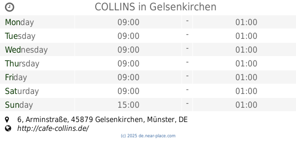
COLLINS
Arminstraße 6, Gelsenkirchen
Night club
read more
5.491 km
Afrika Lounge
Goethestraße 49, Gladbeck
Night club
read more
5.703 km
SV OG Karnap Schäferhund Verein
Arenbergstraße 88, Essen
Night club
read more
📑
all categories
Accounting
Administrative area level 1
Administrative area level 2
Airport
Amusement park
Aquarium
Art gallery
Atm
Bakery
Bank
Bar
Beauty salon
Bicycle store
Book store
Bowling alley
Bus station
Cafe
Campground
Car dealer
Car rental
Car repair
Car wash
Casino
Cemetery
Church
City hall
Clothing store
Colloquial area
Convenience store
Country
Courthouse
Dentist
Department store
Doctor
Electrician
Electronics store
Embassy
Establishment
Finance
Fire station
Florist
Food
Funeral home
Furniture store
Gas station
General contractor
Grocery or supermarket
Gym
Hair care
Hardware store
Health
Hindu Temple
Home goods store
Hospital
Insurance agency
Jewelry store
Laundry
Lawyer
Library
Light rail station
Liquor store
Local government office
Locality
Locksmith
Lodging
Meal delivery
Meal takeaway
Mosque
Movie rental
Movie theater
Moving company
Museum
Natural feature
Neighborhood
Night club
Painter
Park
Parking
Pet store
Pharmacy
Physiotherapist
Place of worship
Plumber
Point of interest
Police
Political
Post office
Premise
Real estate agency
Restaurant
Roofing contractor
Route
Rv park, camping
School
Shoe store
Shopping mall
Spa
Stadium
Storage
Store
Subpremise
Subway station
Supermarket
Synagogue
Taxi stand
Train station
Transit station
Travel agency
University
Veterinary care
Zoo
administrative area level 3
administrative area level 4
sublocality level 1
sublocality level 2
sublocality level 3
↑