Museum nearby THE SHELF
Coronavirus disease (COVID-19) Situation
confirmed cases
38828995
deaths
183027
Germany
Museum nearby THE SHELF
THE SHELF
Prinzenstraße 89, Berlin Germany
contacts phone
:
+49
Latitude:
52.5025574
, Longitude:
13.4091759
read more
nearest Museum
80 m
THE SHELF
Prinzenstraße 34, Berlin
Museum
read more
109 m
METROPOLENHAUS Am Jüdischen Museum GmbH & Co. KG
Lobeckstraße 30, Berlin
Museum
read more
309 m
DAAS
Oranienstraße 161, Berlin
Museum
read more
549 m
F³ - Space for Photography
Waldemarstraße 17, Berlin
Museum
read more
683 m
Atelier - Albrecht Klink
Kreuzberg, Berlin
Museum
read more
702 m
chezweitz GmbH
Adalbertstraße 5-6, Berlin
Museum
read more
729 m
Duncan McCauley
Adalbertstraße 6A, Berlin
Museum
read more
762 m
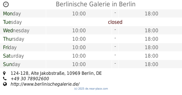
Berlinische Galerie
Alte Jakobstraße 124-128, Berlin
Museum
read more
772 m
Clessidra
Admiralstraße 31, Berlin
Museum
read more
779 m
Gallery EXPO 3036
Naunynstraße 31, Berlin
Museum
read more
794 m
neue Gesellschaft für bildende Kunst e.V.
Oranienstraße 25, Berlin
Museum
read more
795 m
Werkbundarchiv – Museum der Dinge
Oranienstraße 25, Berlin
Museum
read more
835 m
Engeldamm Mauerpark
Mitte, Berlin
Museum
read more
878 m
St. Michael Kirche
Michaelkirchplatz 15, Berlin
Museum
read more
890 m
Naturkundemuseum
Fraenkelufer 16-2, Berlin
Museum
read more
930 m
Muzeum Żydowskie w Berlinie
Lindenstraße 9-14, Berlin
Museum
read more
930 m
Museo Judío de Berlín
Lindenstraße 9-14, Berlin
Museum
read more
937 m
Garten des Exils
Kreuzberg, Berlin
Museum
read more
938 m
Collegienhaus
Lindenstraße 14, Berlin
Museum
read more
939 m
El puente tomar sol
Planufer, Berlin
Museum
read more
943 m
F. Schulte - Schmale Wuerselen
Kreuzberg, Berlin
Museum
read more
944 m
Stream Engine
Unnamed Road, 10969
Museum
read more
1.012 km
synthesis gallery
Köpenicker Straße 95, Berlin
Museum
read more
1.214 km
Metropolenhaus Am Jüdischen Museum GmbH & Co. KG
Köpenicker Straße 48-49, Berlin
Museum
read more
1.309 km
Julia Stoschek Collection
Leipziger Straße 60, Berlin
Museum
read more
📑
all categories
Accounting
Administrative area level 1
Administrative area level 2
Airport
Amusement park
Aquarium
Art gallery
Atm
Bakery
Bank
Bar
Beauty salon
Bicycle store
Book store
Bowling alley
Bus station
Cafe
Campground
Car dealer
Car rental
Car repair
Car wash
Casino
Cemetery
Church
City hall
Clothing store
Colloquial area
Convenience store
Country
Courthouse
Dentist
Department store
Doctor
Electrician
Electronics store
Embassy
Establishment
Finance
Fire station
Florist
Food
Funeral home
Furniture store
Gas station
General contractor
Grocery or supermarket
Gym
Hair care
Hardware store
Health
Hindu Temple
Home goods store
Hospital
Insurance agency
Jewelry store
Laundry
Lawyer
Library
Light rail station
Liquor store
Local government office
Locality
Locksmith
Lodging
Meal delivery
Meal takeaway
Mosque
Movie rental
Movie theater
Moving company
Museum
Natural feature
Neighborhood
Night club
Painter
Park
Parking
Pet store
Pharmacy
Physiotherapist
Place of worship
Plumber
Point of interest
Police
Political
Post office
Premise
Real estate agency
Restaurant
Roofing contractor
Route
Rv park, camping
School
Shoe store
Shopping mall
Spa
Stadium
Storage
Store
Subpremise
Subway station
Supermarket
Synagogue
Taxi stand
Train station
Transit station
Travel agency
University
Veterinary care
Zoo
administrative area level 3
administrative area level 4
sublocality level 1
sublocality level 2
sublocality level 3
↑