Mosque nearby Islamische Union Troisdorf und Umgebung e.V.
Coronavirus disease (COVID-19) Situation
confirmed cases
38828995
deaths
183027
Germany
Mosque nearby Islamische Union Troisdorf und Umgebung e.V.
Islamische Union Troisdorf und Umgebung e.V.
Sieglarer Straße 23, Troisdorf Deutschland
contacts phone
:
+49
Latitude:
50.81442
, Longitude:
7.14465
read more
nearest Mosque
1.148 km
Moschee Ebu Hanife
Teutonenstraße 27, Troisdorf
Mosque
read more
5.465 km
DITIB Türkisch-Islamische Gemeinde zu Siegburg e. V.
Händelstraße 2, Siegburg
Mosque
read more
8.507 km
Deutsch Bosniakisches Kulturzentrum Hajr e. V.
An der Esche 24, Bonn
Mosque
read more
8.614 km
Bonn Süleymaniye Camii
Kölnstraße 361, Bonn
Mosque
read more
8.775 km
Al-Muhsinin Moschee
Schwarzer Weg 40, Bonn
Mosque
read more
8.865 km
Xhamia E Shqiptare
Theaterstraße 12, Bonn
Mosque
read more
9.561 km
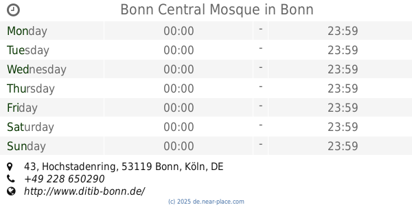
Bonn Central Mosque
Hochstadenring 43, Bonn
Mosque
read more
9.743 km
Al-Muhajirin Moschee Bonn
Brühler Straße 28, Bonn
Mosque
read more
9.743 km
Al-Muhajirin Moschee in Bonn e.V.
Brühler Straße 28, Bonn
Mosque
read more
10.542 km
As-Sonnah Moschee
Siemensstraße 102, Bonn
Mosque
read more
12.602 km
Moschee Haus der Integration
Köslinstraße 28, Bonn
Mosque
read more
13.903 km
Al-Ansar Moschee Bonn
Bonner Straße 93, Bonn
Mosque
read more
14.872 km
Fatih Camii Fatih Moschee
Koblenzer Straße 107, Bonn
Mosque
read more
15.531 km
Tugra Cami
Raiffeisenstraße, Alfter
Mosque
read more
15.629 km
DITIB Türkisch Islamische Kultur Verein e.V.
Raiffeisenstraße 27, Alfter
Mosque
read more
15.864 km
Vingst Camii
Ostheimer Straße 51, Köln
Mosque
read more
16.537 km
Gemeinschaft der Mitte e.V.
Olpener Straße 33, Köln
Mosque
read more
16.732 km
Marokkanische Moschee, Masjed, جامع , مسجد, المغربي
Emser Straße 2, Köln
Mosque
read more
16.744 km
Taqiyyu d-Din al-Hilali Moschee
Taunusstraße 34, Köln
Mosque
read more
17.001 km
Mosque
Eythstraße 44, Köln
Mosque
read more
17.114 km
Islamische Kulturgemeinde Köln
Kalk-Mülheimer Straße 21, Köln
Mosque
read more
17.217 km
Kuba Moschee
Vorsterstraße 41, Köln
Mosque
read more
17.685 km
Масджид Ат-Таухид
Kalk-Mülheimer Straße 210, Köln
Mosque
read more
18.004 km
ATIB Hoca Ahmed Yesevi Cami
Kartäuserwall 59, Köln
Mosque
read more
18.536 km
Abu Bakr Moschee
Höninger Weg 5, Köln
Mosque
read more
📑
all categories
Accounting
Administrative area level 1
Administrative area level 2
Airport
Amusement park
Aquarium
Art gallery
Atm
Bakery
Bank
Bar
Beauty salon
Bicycle store
Book store
Bowling alley
Bus station
Cafe
Campground
Car dealer
Car rental
Car repair
Car wash
Casino
Cemetery
Church
City hall
Clothing store
Colloquial area
Convenience store
Country
Courthouse
Dentist
Department store
Doctor
Electrician
Electronics store
Embassy
Establishment
Finance
Fire station
Florist
Food
Funeral home
Furniture store
Gas station
General contractor
Grocery or supermarket
Gym
Hair care
Hardware store
Health
Hindu Temple
Home goods store
Hospital
Insurance agency
Jewelry store
Laundry
Lawyer
Library
Light rail station
Liquor store
Local government office
Locality
Locksmith
Lodging
Meal delivery
Meal takeaway
Mosque
Movie rental
Movie theater
Moving company
Museum
Natural feature
Neighborhood
Night club
Painter
Park
Parking
Pet store
Pharmacy
Physiotherapist
Place of worship
Plumber
Point of interest
Police
Political
Post office
Premise
Real estate agency
Restaurant
Roofing contractor
Route
Rv park, camping
School
Shoe store
Shopping mall
Spa
Stadium
Storage
Store
Subpremise
Subway station
Supermarket
Synagogue
Taxi stand
Train station
Transit station
Travel agency
University
Veterinary care
Zoo
administrative area level 3
administrative area level 4
sublocality level 1
sublocality level 2
sublocality level 3
↑