Lodging nearby ODiN Hostel
Coronavirus disease (COVID-19) Situation
confirmed cases
38828995
deaths
183027
Germany
Lodging nearby ODiN Hostel
ODiN Hostel
Am Neuen Weinberg 3, Viernheim Alemania
contacts phone
:
+49
Latitude:
49.5449933
, Longitude:
8.5720128
read more
nearest Lodging
244 m
Siedlerheim
Kirschenstraße 66, Viernheim
Lodging
read more
320 m
Geunsen
Lorscher Straße 74, Viernheim
Lodging
read more
627 m
Sporthotel Fetsch
Einsteinstraße 13, Viernheim
Lodging
read more
801 m
Hotel Post Viernheim UG
Luisenstraße 1, Viernheim
Lodging
read more
1.031 km
cleron
Repsgasse 10, Viernheim
Lodging
read more
1.178 km
Pension Polzin
Hügelstraße 24, Viernheim
Lodging
read more
1.205 km
Alter Gasthof Betriebsges. mbH
Erzbergerstraße 33, Viernheim
Lodging
read more
1.269 km
looks-inn
71 Wiesenstrasse 11-26, Viernheim
Lodging
read more
1.271 km
Donnici im Schwyzerhüsli
Max-Planck-Straße 22, Viernheim
Lodging
read more
1.271 km
Schwyzerhüsli
Max-Planck-Straße 22, Viernheim
Lodging
read more
1.276 km
Waterfront Appartements GmbH
Friedrich-Ebert-Straße 47, Viernheim
Lodging
read more
1.539 km
Monteurzimmervermietung
Heinrich-Lanz-Ring 41, Viernheim
Lodging
read more
1.56 km
Apart-Hotel Tenne
Kiesstraße 2, Viernheim
Lodging
read more
1.591 km
Hotel Am Kapellenberg
Mannheimer Straße 59, Viernheim
Lodging
read more
1.638 km
Schekelmann
Heinrich-Lanz-Ring 30, Viernheim
Lodging
read more
1.751 km
Kant-Haus
Kantstraße 3, Viernheim
Lodging
read more
1.761 km
Cavallo d´Argento
Walter-Oehmichen-Straße 18, Viernheim
Lodging
read more
1.768 km
Central-Hotel am Königshof
Hölderlinstraße 4, Viernheim
Lodging
read more
1.852 km
Hotel Andermann
Heinrich-Lanz-Ring 10, Viernheim
Lodging
read more
2.013 km
Hotel NH Mannheim Viernheim
Bürgermeister-Neff-Straße 12, Viernheim
Lodging
read more
2.74 km
Reitsport Hildenbrand
Am Alten Weinheimer Weg 26, Viernheim
Lodging
read more
3.184 km
MONTAGO Mannheim
Spreewaldallee 45, Mannheim
Lodging
read more
4.882 km
Ferienwohnung Weinheim
Kiefernweg 11, Weinheim
Lodging
read more
5.331 km
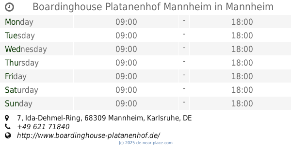
Boardinghouse Platanenhof Mannheim
Ida-Dehmel-Ring 7, Mannheim
Lodging
read more
5.555 km
Hotel am Park
Mannheimer Straße 34, Mannheim
Lodging
read more
📑
all categories
Accounting
Administrative area level 1
Administrative area level 2
Airport
Amusement park
Aquarium
Art gallery
Atm
Bakery
Bank
Bar
Beauty salon
Bicycle store
Book store
Bowling alley
Bus station
Cafe
Campground
Car dealer
Car rental
Car repair
Car wash
Casino
Cemetery
Church
City hall
Clothing store
Colloquial area
Convenience store
Country
Courthouse
Dentist
Department store
Doctor
Electrician
Electronics store
Embassy
Establishment
Finance
Fire station
Florist
Food
Funeral home
Furniture store
Gas station
General contractor
Grocery or supermarket
Gym
Hair care
Hardware store
Health
Hindu Temple
Home goods store
Hospital
Insurance agency
Jewelry store
Laundry
Lawyer
Library
Light rail station
Liquor store
Local government office
Locality
Locksmith
Lodging
Meal delivery
Meal takeaway
Mosque
Movie rental
Movie theater
Moving company
Museum
Natural feature
Neighborhood
Night club
Painter
Park
Parking
Pet store
Pharmacy
Physiotherapist
Place of worship
Plumber
Point of interest
Police
Political
Post office
Premise
Real estate agency
Restaurant
Roofing contractor
Route
Rv park, camping
School
Shoe store
Shopping mall
Spa
Stadium
Storage
Store
Subpremise
Subway station
Supermarket
Synagogue
Taxi stand
Train station
Transit station
Travel agency
University
Veterinary care
Zoo
administrative area level 3
administrative area level 4
sublocality level 1
sublocality level 2
sublocality level 3
↑