Local government office nearby Dorfgemeinschaftshaus Angern
Coronavirus disease (COVID-19) Situation
confirmed cases
38828995
deaths
183027
Germany
Local government office nearby Dorfgemeinschaftshaus Angern
Dorfgemeinschaftshaus Angern
39326 Angern, Germany
contacts phone
:
+49
Latitude:
52.3612324
, Longitude:
11.73151
larger map & directions
read more
nearest Local government office
8.581 km
Gemeindeverwaltung Rogätz
Ramstedter Straße 26, Zielitz
Local government office
Point of interest
Establishment
read more
8.581 km
Verwaltungsgemeinschaft Elbe-Ohre
Ramstedter Straße 26, Zielitz
City hall
Local government office
Point of interest
Establishment
read more
8.855 km
Bundesforstbetrieb Nördliches Sachsen-Anhalt Bundesforstverwaltung
Steinberge 1, Dolle
Local government office
Park
Point of interest
Establishment
read more
8.926 km
Bauhof Zielitz
Zielitz
City hall
Local government office
Point of interest
Establishment
read more
9.252 km
Gemeindeverwaltung Dolle
Braune-Hirsch-Straße 7, Dolle
Local government office
Point of interest
Establishment
read more
9.628 km
Stadt Tangerhütte
Bismarckstraße 5, Tangerhütte
City hall
Local government office
Point of interest
Establishment
read more
12.547 km
Landkreis Jerichower Land Kreisverwaltung
Bahnhofstraße 9, Burg (bei Magdeburg)
Local government office
Point of interest
Establishment
read more
12.703 km
Christoph Kroschke GmbH
In der Alten Kaserne 8 nahe Landkreis Jerichower Land Kreisverwaltung, Burg (bei Magdeburg)
Local government office
Car repair
Point of interest
Store
Establishment
read more
12.782 km
Stadtverwaltung Burg
In der Alten Kaserne 2, Burg (bei Magdeburg)
Local government office
Point of interest
Establishment
read more
13.077 km
Dir Burg spiegel
Magdeburger Chaussee 5, Burg (bei Magdeburg)
City hall
Local government office
Point of interest
Establishment
read more
13.169 km
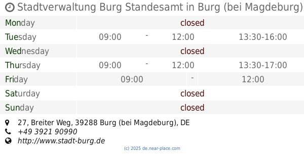
Stadtverwaltung Burg Standesamt
Breiter Weg 27, Burg (bei Magdeburg)
Local government office
Point of interest
Establishment
read more
13.933 km
St. Nikolai -Evangelische Kirchengemeinde Glindenberg
Veilchenweg, la
City hall
Local government office
Point of interest
Establishment
read more
14.799 km
Kommunalservice Landkreis Börde AöR
Schwimmbadstraße 2A, Wolmirstedt
Local government office
Point of interest
Establishment
read more
19.228 km
Rathaus Barleben
Breiteweg 49, Barleben
City hall
Local government office
Point of interest
Establishment
read more
19.255 km
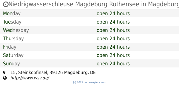
Niedrigwasserschleuse Magdeburg Rothensee
Steinkopfinsel 15, Magdeburg
Local government office
Point of interest
Establishment
read more
20.283 km
NABU-Kreisverband Stendal
Querstraße 22, Tangermünde
City hall
Local government office
Point of interest
Establishment
read more
20.91 km
Gemeindeverwaltung Gerwisch
Breiter Weg 38, Gerwisch
Local government office
Point of interest
Establishment
read more
23.016 km
Community Office City Hall Haldensleben
Markt 20-22, Haldensleben
City hall
Local government office
Point of interest
Establishment
read more
23.116 km
Jenrich Vermessungsgesellschaft mbH
Hohenwarsleber Straße 6, Niedere Börde
Local government office
Point of interest
Establishment
read more
23.458 km
Gesundheitsamt der Stadt Magdeburg
Lübecker Straße 32, Magdeburg
Local government office
Health
Point of interest
Establishment
read more
24.496 km
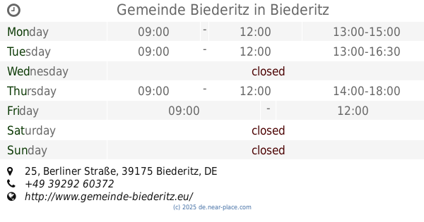
Gemeinde Biederitz
Berliner Straße 25, Biederitz
Local government office
Point of interest
Establishment
read more
24.578 km
Bezirksamt für Straßenbau
Agnetenstraße 14, Magdeburg
Local government office
read more
25.429 km
Stadtplanungsamt Magdeburg
An der Steinkuhle 6, Magdeburg
Local government office
read more
25.459 km
Magdeburg Employment Agency
Hohepfortestraße 37, Magdeburg
Local government office
read more
26.202 km
BürgerBüro West
Bruno-Beye-Ring 50, Magdeburg
Local government office
read more
📑
all categories
Accounting
Administrative area level 1
Administrative area level 2
Airport
Amusement park
Aquarium
Art gallery
Atm
Bakery
Bank
Bar
Beauty salon
Bicycle store
Book store
Bowling alley
Bus station
Cafe
Campground
Car dealer
Car rental
Car repair
Car wash
Casino
Cemetery
Church
City hall
Clothing store
Colloquial area
Convenience store
Country
Courthouse
Dentist
Department store
Doctor
Electrician
Electronics store
Embassy
Establishment
Finance
Fire station
Florist
Food
Funeral home
Furniture store
Gas station
General contractor
Grocery or supermarket
Gym
Hair care
Hardware store
Health
Hindu Temple
Home goods store
Hospital
Insurance agency
Jewelry store
Laundry
Lawyer
Library
Light rail station
Liquor store
Local government office
Locality
Locksmith
Lodging
Meal delivery
Meal takeaway
Mosque
Movie rental
Movie theater
Moving company
Museum
Natural feature
Neighborhood
Night club
Painter
Park
Parking
Pet store
Pharmacy
Physiotherapist
Place of worship
Plumber
Point of interest
Police
Political
Post office
Premise
Real estate agency
Restaurant
Roofing contractor
Route
Rv park, camping
School
Shoe store
Shopping mall
Spa
Stadium
Storage
Store
Subpremise
Subway station
Supermarket
Synagogue
Taxi stand
Train station
Transit station
Travel agency
University
Veterinary care
Zoo
administrative area level 3
administrative area level 4
sublocality level 1
sublocality level 2
sublocality level 3
↑