Health nearby Esprivida Pflegedienst
Coronavirus disease (COVID-19) Situation
confirmed cases
38828995
deaths
183027
Germany
Health nearby Esprivida Pflegedienst
Esprivida Pflegedienst
Dombühler Straße 2, Nürnberg Tyskland
contacts phone
:
+49
Latitude:
49.4215566
, Longitude:
11.0332447
read more
nearest Health
416 m
Naturheilpraxis Rudolf Eckert
Feuchtwanger Straße 16, Nürnberg
Health
read more
480 m
Naturheilpraxis und Ästhetik
Feuchtwanger Straße 25 b, Nürnberg
Health
read more
694 m
Sana Clinic Nuremberg
Weiltinger Straße 11, Nürnberg
Hospital
Health
Point of interest
Establishment
read more
702 m
MedicAir Deutschland GmbH
Dieselstraße 77, Nürnberg
Health
read more
721 m
Wing tsun algailani
Dieselstraße 77, Nürnberg
Health
read more
791 m
TENNISJESSEN Standort Post SV Schweinau
Daimlerstraße 71, Nürnberg
Health
read more
960 m
Praxis für ästhetische Medizin und Naturheilkunde
Weiltinger Straße 46, Nürnberg
Health
read more
1.125 km
Ceragem Ansbach
Schweinauer Hauptstraße 99, Nürnberg
Health
read more
1.38 km
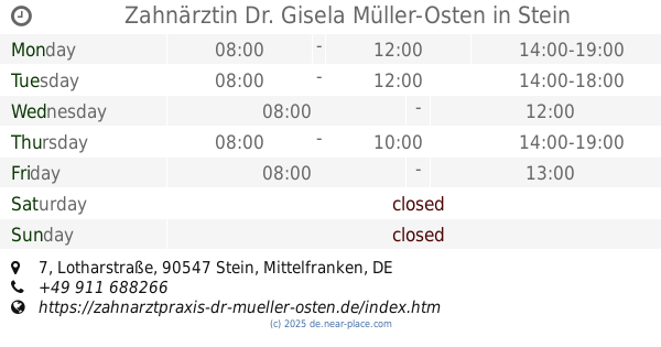
Zahnärztin Dr. Gisela Müller-Osten
Lotharstraße 7, Stein
Dentist
Doctor
Health
Point of interest
Establishment
read more
1.649 km
Ergotherapeutische & Logopädische Praxis E. Vollus GmbH
Eibacher Hauptstraße 21, Nürnberg
Health
read more
1.656 km
Atlaslogie Karin Fabritius
Brandenburger Straße 109B, Nürnberg
Health
read more
1.704 km
yourSENSE e.K. - Sylvia Andrea Maß
Konstanzenstraße 80, Nürnberg
Health
read more
1.79 km
Praxis für Psychotherapie Hubmann &Schröder
Schweinauer Hauptstraße 14 d, Nürnberg
Health
read more
1.805 km
Smart Vein Repair
Schweinauer Hauptstraße 12, Nürnberg
Health
read more
2.156 km
Praxis für Ergotherapie im Stapf
Leopoldstraße 34, Nürnberg
Health
read more
📑
all categories
Accounting
Administrative area level 1
Administrative area level 2
Airport
Amusement park
Aquarium
Art gallery
Atm
Bakery
Bank
Bar
Beauty salon
Bicycle store
Book store
Bowling alley
Bus station
Cafe
Campground
Car dealer
Car rental
Car repair
Car wash
Casino
Cemetery
Church
City hall
Clothing store
Colloquial area
Convenience store
Country
Courthouse
Dentist
Department store
Doctor
Electrician
Electronics store
Embassy
Establishment
Finance
Fire station
Florist
Food
Funeral home
Furniture store
Gas station
General contractor
Grocery or supermarket
Gym
Hair care
Hardware store
Health
Hindu Temple
Home goods store
Hospital
Insurance agency
Jewelry store
Laundry
Lawyer
Library
Light rail station
Liquor store
Local government office
Locality
Locksmith
Lodging
Meal delivery
Meal takeaway
Mosque
Movie rental
Movie theater
Moving company
Museum
Natural feature
Neighborhood
Night club
Painter
Park
Parking
Pet store
Pharmacy
Physiotherapist
Place of worship
Plumber
Point of interest
Police
Political
Post office
Premise
Real estate agency
Restaurant
Roofing contractor
Route
Rv park, camping
School
Shoe store
Shopping mall
Spa
Stadium
Storage
Store
Subpremise
Subway station
Supermarket
Synagogue
Taxi stand
Train station
Transit station
Travel agency
University
Veterinary care
Zoo
administrative area level 3
administrative area level 4
sublocality level 1
sublocality level 2
sublocality level 3
↑