Gas station nearby Tank-MAX
Coronavirus disease (COVID-19) Situation
confirmed cases
38828995
deaths
183027
Germany
Gas station nearby Tank-MAX
Tank-MAX
Industriestraße 2, Steinbach (Taunus) Germany
contacts phone
:
+49
Latitude:
50.1711041
, Longitude:
8.5831593
read more
nearest Gas station
Lotto-Verkaufsstelle
Industriestraße 2, Steinbach (Taunus)
Gas station
read more
32 m
Freie Tankstelle
Industriestraße 2, Steinbach (Taunus)
Gas station
read more
1.125 km
Steinbach Eschborner Straße 34
Eschborner Straße 34, Steinbach (Taunus)
Gas station
read more
1.133 km
Lotto-Verkaufsstelle
Eschborner Straße 34, Steinbach (Taunus)
Gas station
read more
1.133 km
Esso
Eschborner Straße 34, Steinbach (Taunus)
Gas station
read more
2.166 km
Shell
A5, Taunusblick, Eschborn
Gas station
read more
2.171 km
Raststätte Taunusblick Eschborn
A5, Eschborn
Gas station
read more
3.032 km
Shell
Hauptstraße 235, Eschborn
Gas station
read more
3.137 km
Gas station at the supermarket
Ginnheimer Straße 16, Eschborn
Gas station
read more
3.142 km
Real Markt Tankstelle
Ginnheimer Straße 8, Eschborn
Gas station
read more
3.148 km
Basam KFZ
Rödelheimer Straße 53, Eschborn
Gas station
read more
3.198 km
Selgros
Praunheimer Straße 5-11, Eschborn
Gas station
read more
3.306 km
Aral
Sodener Straße 29, Kronberg im Taunus
Gas station
read more
3.372 km
Lotto-Verkaufsstelle
Heerstraße 78, Frankfurt am Main
Gas station
read more
3.386 km
TOTAL Tankstelle
Heerstraße 78, Frankfurt am Main
Gas station
read more
3.742 km
Shell
Zeilsheimer Weg 1, Eschborn
Gas station
read more
3.807 km
Lotto-Verkaufsstelle
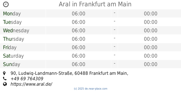
Ludwig-Landmann-Straße 90, Frankfurt am Main
Gas station
read more
3.811 km
Aral
Ludwig-Landmann-Straße 90, Frankfurt am Main
Gas station
read more
4.213 km
Gas station at the supermarket
Guerickestraße 8a, Frankfurt am Main
Gas station
read more
4.508 km
bft Tankstelle Oel Zügel
74 In der Römerstadt, Frankfurt am Main
Gas station
read more
4.641 km
Gebrüder Steier oHG Freie Tankstelle / Wildspezialitäten
Sulzbacher Straße 43, Schwalbach am Taunus
Gas station
read more
5.01 km
Esso
Frankfurter Straße 15, Kronberg im Taunus
Gas station
read more
5.114 km
Esso
Ludwig-Landmann-Straße 339, Frankfurt am Main
Gas station
read more
5.267 km
Hessol
Max-Holder-Straße 2, Frankfurt am Main
Gas station
read more
5.309 km
SB-Wäsche Car Wash
Frankfurt am Main
Gas station
read more
📑
all categories
Accounting
Administrative area level 1
Administrative area level 2
Airport
Amusement park
Aquarium
Art gallery
Atm
Bakery
Bank
Bar
Beauty salon
Bicycle store
Book store
Bowling alley
Bus station
Cafe
Campground
Car dealer
Car rental
Car repair
Car wash
Casino
Cemetery
Church
City hall
Clothing store
Colloquial area
Convenience store
Country
Courthouse
Dentist
Department store
Doctor
Electrician
Electronics store
Embassy
Establishment
Finance
Fire station
Florist
Food
Funeral home
Furniture store
Gas station
General contractor
Grocery or supermarket
Gym
Hair care
Hardware store
Health
Hindu Temple
Home goods store
Hospital
Insurance agency
Jewelry store
Laundry
Lawyer
Library
Light rail station
Liquor store
Local government office
Locality
Locksmith
Lodging
Meal delivery
Meal takeaway
Mosque
Movie rental
Movie theater
Moving company
Museum
Natural feature
Neighborhood
Night club
Painter
Park
Parking
Pet store
Pharmacy
Physiotherapist
Place of worship
Plumber
Point of interest
Police
Political
Post office
Premise
Real estate agency
Restaurant
Roofing contractor
Route
Rv park, camping
School
Shoe store
Shopping mall
Spa
Stadium
Storage
Store
Subpremise
Subway station
Supermarket
Synagogue
Taxi stand
Train station
Transit station
Travel agency
University
Veterinary care
Zoo
administrative area level 3
administrative area level 4
sublocality level 1
sublocality level 2
sublocality level 3
↑