Gas station nearby Shell
Coronavirus disease (COVID-19) Situation
confirmed cases
38828995
deaths
183027
Germany
Gas station nearby Shell
Shell
Pariser Straße 131, Nieder-Olm Germany
contacts phone
:
+49
Latitude:
49.907599
, Longitude:
8.19894
read more
nearest Gas station
214 m
Kfz - Klein
Am Woog 7, Nieder-Olm
Gas station
read more
1.645 km
Shell
Am Giener 25, Nieder-Olm
Gas station
read more
3.41 km
Esso
Pariser Straße 53, Klein-Winternheim
Gas station
read more
4.998 km
Saling LPG Klein-Winternheim
Am Pfaffenstein 5, Klein-Winternheim
Gas station
read more
5.05 km
Autohaus Kieber GmbH
Am Kesseltal 2, Mainz
Gas station
read more
5.062 km
TOTAL Tankstelle
Am Kesseltal 4, Mainz
Gas station
read more
6.332 km
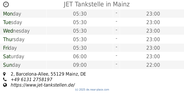
JET Tankstelle
Barcelona-Allee 2, Mainz
Gas station
read more
7.135 km
JET Tankstelle
Haifa-Allee 1, Mainz
Gas station
read more
10.371 km
OIL! Tankstelle
Oppenheimer Straße 59, Mainz
Gas station
read more
10.467 km
AVIA Station Thelen GmbH & Co. KG
Lennebergstraße 1, Mainz
Gas station
read more
10.833 km
TOTAL Tankstelle
Binger Straße 27, Mainz
Gas station
read more
12.337 km
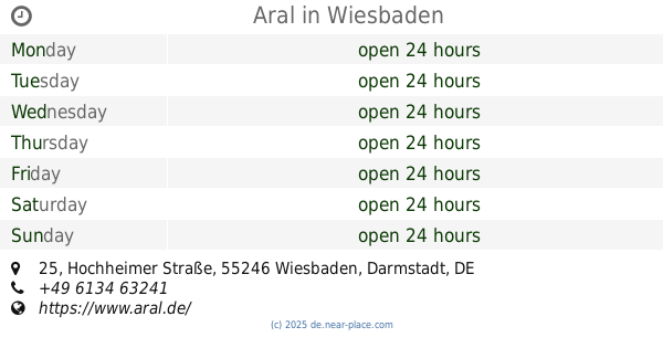
Aral
A60, Heidesheim am Rhein
Gas station
read more
12.359 km
Raststätte Heidenfahrt-Nord
Unnamed Road,55262, Heidesheim am Rhein
Gas station
read more
12.523 km
bft-Tankstelle
Rheinallee 87, Mainz
Gas station
read more
12.613 km
Thelen GmbH & Co. KG Mineralölvertrieb
Gräfin-Dönhoff-Straße 2, Ginsheim-Gustavsburg
Gas station
read more
12.691 km
Tankstelle
Mainz
Gas station
read more
12.9 km
Star
Darmstädter Landstraße 11, Ginsheim-Gustavsburg
Gas station
read more
12.986 km
Aral
Hochheimer Straße 25, Wiesbaden
Gas station
read more
13.134 km
CLASSIC Tankstelle
Hochheimer Straße 47, Wiesbaden
Gas station
read more
13.148 km
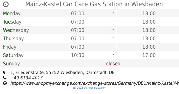
Mainz-Kastel Car Care Gas Station
Friedenstraße 1, Wiesbaden
Gas station
read more
13.434 km
Agip Service-Station
Wiesbadener Straße 68, Wiesbaden
Gas station
read more
13.487 km
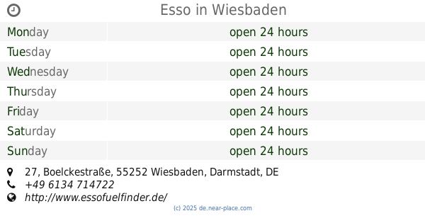
Esso
Boelckestraße 27, Wiesbaden
Gas station
read more
14.115 km
Gas station at the supermarket
Boelckestraße 78, Wiesbaden
Gas station
read more
16.611 km
OIL! Tankstelle
Frankfurter Straße 63, Hochheim am Main
Gas station
read more
17.562 km
Gaveg
Karlstraße 1, Rüsselsheim am Main
Gas station
read more
📑
all categories
Accounting
Administrative area level 1
Administrative area level 2
Airport
Amusement park
Aquarium
Art gallery
Atm
Bakery
Bank
Bar
Beauty salon
Bicycle store
Book store
Bowling alley
Bus station
Cafe
Campground
Car dealer
Car rental
Car repair
Car wash
Casino
Cemetery
Church
City hall
Clothing store
Colloquial area
Convenience store
Country
Courthouse
Dentist
Department store
Doctor
Electrician
Electronics store
Embassy
Establishment
Finance
Fire station
Florist
Food
Funeral home
Furniture store
Gas station
General contractor
Grocery or supermarket
Gym
Hair care
Hardware store
Health
Hindu Temple
Home goods store
Hospital
Insurance agency
Jewelry store
Laundry
Lawyer
Library
Light rail station
Liquor store
Local government office
Locality
Locksmith
Lodging
Meal delivery
Meal takeaway
Mosque
Movie rental
Movie theater
Moving company
Museum
Natural feature
Neighborhood
Night club
Painter
Park
Parking
Pet store
Pharmacy
Physiotherapist
Place of worship
Plumber
Point of interest
Police
Political
Post office
Premise
Real estate agency
Restaurant
Roofing contractor
Route
Rv park, camping
School
Shoe store
Shopping mall
Spa
Stadium
Storage
Store
Subpremise
Subway station
Supermarket
Synagogue
Taxi stand
Train station
Transit station
Travel agency
University
Veterinary care
Zoo
administrative area level 3
administrative area level 4
sublocality level 1
sublocality level 2
sublocality level 3
↑