Gas station nearby JET Tankstelle
Coronavirus disease (COVID-19) Situation
confirmed cases
38828995
deaths
183027
Germany
Gas station nearby JET Tankstelle
JET Tankstelle
65, Homburger Straße, 66424, Homburg, DE Germany
contacts phone
:
+49 6848 72115
website:
www.jet.de
Latitude:
49.2853
, Longitude:
7.3162
larger map & directions
read more
nearest Gas station
11.72 km
JET Tankstelle
Süduferstraße 20, Neunkirchen
Gas station
Cafe
Supermarket
Grocery or supermarket
Book store
Restaurant
Food
Point of interest
Store
Establishment
read more
15.682 km
Rainer Kappes
Ensheimer Straße 152, Sankt Ingbert
Gas station
read more
19.242 km
Freie Tankstelle & Kfz-Service Quack UG (haftungsbeschränkt)
Hauptstraße 36, Saarbrücken
Gas station
read more
20.889 km
Shell
Provinzialstraße 2, Saarbrücken
Gas station
read more
20.938 km
BMW Stromtanke Saarbrücken
Am Halberg 6, Saarbrücken
Gas station
read more
22.224 km
TotalEnergies
Sulzbachtalstraße 19, Saarbrücken
Gas station
Car wash
Cafe
Bakery
Store
Food
Point of interest
Establishment
read more
22.227 km
TOTAL Tankstelle
Sulzbachtalstraße 19, Saarbrücken
Gas station
read more
22.614 km
GLOBUS Station
Am Globus, Sankt Gangloff
Gas station
read more
22.725 km
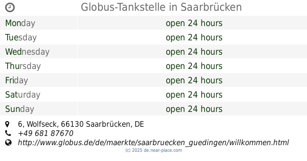
Globus-Tankstelle
Wolfseck 6, Saarbrücken
Gas station
read more
23.096 km
Aral
Neumühler Weg 14, Saarbrücken
Gas station
read more
23.19 km
TOTAL Tankstelle
Martin-Luther-Straße 21, Saarbrücken
Gas station
read more
23.363 km
LPGo
Dudweilerstraße 111, Saarbrücken
Gas station
read more
23.638 km
T-Tankstelle
Großblittersdorfer Straße 252, Saarbrücken
Gas station
read more
23.64 km
Independent Saarbrücken
Großblittersdorfer Straße 252, Saarbrücken
Gas station
read more
25.152 km
Tankcenter Saarbrücken
Deutschherrnstraße 34-40, Saarbrücken
Gas station
read more
📑
all categories
Accounting
Administrative area level 1
Administrative area level 2
Airport
Amusement park
Aquarium
Art gallery
Atm
Bakery
Bank
Bar
Beauty salon
Bicycle store
Book store
Bowling alley
Bus station
Cafe
Campground
Car dealer
Car rental
Car repair
Car wash
Casino
Cemetery
Church
City hall
Clothing store
Colloquial area
Convenience store
Country
Courthouse
Dentist
Department store
Doctor
Electrician
Electronics store
Embassy
Establishment
Finance
Fire station
Florist
Food
Funeral home
Furniture store
Gas station
General contractor
Grocery or supermarket
Gym
Hair care
Hardware store
Health
Hindu Temple
Home goods store
Hospital
Insurance agency
Jewelry store
Laundry
Lawyer
Library
Light rail station
Liquor store
Local government office
Locality
Locksmith
Lodging
Meal delivery
Meal takeaway
Mosque
Movie rental
Movie theater
Moving company
Museum
Natural feature
Neighborhood
Night club
Painter
Park
Parking
Pet store
Pharmacy
Physiotherapist
Place of worship
Plumber
Point of interest
Police
Political
Post office
Premise
Real estate agency
Restaurant
Roofing contractor
Route
Rv park, camping
School
Shoe store
Shopping mall
Spa
Stadium
Storage
Store
Subpremise
Subway station
Supermarket
Synagogue
Taxi stand
Train station
Transit station
Travel agency
University
Veterinary care
Zoo
administrative area level 3
administrative area level 4
sublocality level 1
sublocality level 2
sublocality level 3
↑