Gas station nearby Freie Tankstelle Dorstener Straße
Coronavirus disease (COVID-19) Situation
confirmed cases
38828995
deaths
183027
Germany
Gas station nearby Freie Tankstelle Dorstener Straße
Freie Tankstelle Dorstener Straße
548, Dorstener Straße, 44653, Herne, Arnsberg, DE Deutschland
contacts phone
:
+49 2325 794758
Latitude:
51.5453699
, Longitude:
7.1479266
larger map & directions
read more
nearest Gas station
87 m
Tankstelle Klaeser
Dorstener Straße 548, Herne
Gas station
read more
189 m
TuT Tankstellen- u. Tiefbau GmbH
Resser Straße 47, Herne
Gas station
read more
310 m
Campingsalon ZimmerMann GmbH
Resser Straße 53, Herne
Gas station
read more
896 m
TOTAL Tankstelle
Karlstraße 44, Herne
Gas station
read more
1.532 km
SB-Tankstelle Cin
Heerstraße 43 a, Herne
Gas station
read more
1.793 km
star Tankstelle
Schlachthofstraße 37, Herne
Gas station
read more
1.909 km
JET
Berliner Straße 31, Herne
Gas station
read more
1.91 km
JET Tankstelle
Berliner Straße 31, Herne
Gas station
read more
2.258 km
Shell
Herner Straße 76, Herne
Gas station
read more
2.692 km
TOTAL Tankstelle
Eickeler Bruch 143, Herne
Gas station
read more
2.755 km
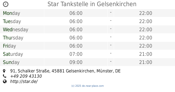
star Tankstelle
Bismarckstraße 314, Gelsenkirchen
Gas station
read more
2.755 km
Star Tankstelle (Orlen Deutschland)
Bismarckstraße 314, Gelsenkirchen
Gas station
read more
2.915 km
Aral
Bismarckstraße 280, Gelsenkirchen
Gas station
read more
3.263 km
SB Tankstelle Derin
Dorneburger Straße 18, Herne
Gas station
read more
3.407 km
TOTAL Tankstelle
Dorstener Straße 201, Herne
Gas station
read more
3.491 km
SB Tankstelle Inh. Waldemar Klehr
Hüller Straße 12, Gelsenkirchen
Gas station
read more
4.254 km
Westfalen Tankstelle
Brauckstraße 160, Gelsenkirchen
Gas station
read more
4.922 km
bft
Westring 102, Herne
Gas station
read more
5.037 km
Nienhaus Autogas
Gewerkenstraße 40, Gelsenkirchen
Gas station
read more
5.058 km
Star Tankstelle
Schalker Straße 91, Gelsenkirchen
Gas station
read more
5.281 km
HEM Tankstelle
Bochumer Straße 110, Herne
Gas station
read more
5.385 km
E. Cakmak GmbH
Herner Straße 463, Bochum
Gas station
read more
5.977 km
Tankstelle Sb
Tiroler Straße 7, Recklinghausen
Gas station
read more
5.987 km
Independent Tiroler Straße
Tiroler Straße 7, Recklinghausen
Gas station
read more
6.496 km
Markant Tankstelle
Herner Straße 269, Bochum
Gas station
read more
📑
all categories
Accounting
Administrative area level 1
Administrative area level 2
Airport
Amusement park
Aquarium
Art gallery
Atm
Bakery
Bank
Bar
Beauty salon
Bicycle store
Book store
Bowling alley
Bus station
Cafe
Campground
Car dealer
Car rental
Car repair
Car wash
Casino
Cemetery
Church
City hall
Clothing store
Colloquial area
Convenience store
Country
Courthouse
Dentist
Department store
Doctor
Electrician
Electronics store
Embassy
Establishment
Finance
Fire station
Florist
Food
Funeral home
Furniture store
Gas station
General contractor
Grocery or supermarket
Gym
Hair care
Hardware store
Health
Hindu Temple
Home goods store
Hospital
Insurance agency
Jewelry store
Laundry
Lawyer
Library
Light rail station
Liquor store
Local government office
Locality
Locksmith
Lodging
Meal delivery
Meal takeaway
Mosque
Movie rental
Movie theater
Moving company
Museum
Natural feature
Neighborhood
Night club
Painter
Park
Parking
Pet store
Pharmacy
Physiotherapist
Place of worship
Plumber
Point of interest
Police
Political
Post office
Premise
Real estate agency
Restaurant
Roofing contractor
Route
Rv park, camping
School
Shoe store
Shopping mall
Spa
Stadium
Storage
Store
Subpremise
Subway station
Supermarket
Synagogue
Taxi stand
Train station
Transit station
Travel agency
University
Veterinary care
Zoo
administrative area level 3
administrative area level 4
sublocality level 1
sublocality level 2
sublocality level 3
↑