Gas station nearby AVIA
Coronavirus disease (COVID-19) Situation
confirmed cases
38828995
deaths
183027
Germany
Gas station nearby AVIA
AVIA
Dorstener Straße 476, Bochum Alemania
contacts phone
:
+49
Latitude:
51.5112252
, Longitude:
7.190625
read more
nearest Gas station
14 m
Tank Point free gas station
Dorstener Straße 476, Bochum
Gas station
read more
14 m
Tank Point
Dorstener Straße 476, Bochum
Gas station
read more
419 m
JET
Riemker Straße 11, Bochum
Gas station
read more
1.111 km
star Tankstelle
Dorstener Straße 343, Bochum
Gas station
read more
1.365 km
Aral
Herner Straße 403, Bochum
Gas station
read more
1.559 km
SB Tankstelle Derin
Dorneburger Straße 18, Herne
Gas station
read more
1.712 km
EPT Automatenstation
Südstraße 110, Herne
Gas station
read more
1.728 km
Electro Oil GmbH
Berggate 28, Bochum
Gas station
read more
1.732 km
E. Cakmak GmbH
Herner Straße 463, Bochum
Gas station
read more
1.752 km
Shell
Herner Straße 463, Bochum
Gas station
read more
1.763 km
Markant Tankstelle
Herner Straße 269, Bochum
Gas station
read more
1.77 km
TOTAL Tankstelle
Dorstener Straße 201, Herne
Gas station
read more
1.865 km
Aral
Herner Straße 256, Bochum
Gas station
read more
2.469 km
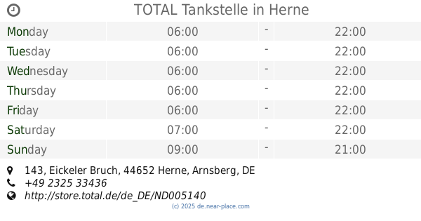
TOTAL Tankstelle
Eickeler Bruch 143, Herne
Gas station
read more
2.646 km
Tankpool24
Seilfahrt 6, Bochum
Gas station
read more
2.658 km
tankpool24 DS card+drive GmbH Automatentankstelle
Seilfahrt 6, Bochum
Gas station
read more
2.811 km
HEM Tankstelle
Bochumer Straße 110, Herne
Gas station
read more
2.838 km
HEM Tankstelle
Gahlensche Straße 93, Bochum
Gas station
read more
2.865 km
TZR Autogas Tankstelle
Holsterhauser Straße 295, Herne
Gas station
read more
2.939 km
JET Tankstelle
Berliner Straße 31, Herne
Gas station
read more
2.94 km
JET
Berliner Straße 31, Herne
Gas station
read more
3.081 km
Shell
Herner Straße 76, Herne
Gas station
read more
3.225 km
SB Tank Alcan
Nordring 40, Bochum
Gas station
read more
3.226 km
SB Tankstelle Rheinland Kraftstoff GmbH
Nordring 40, Bochum
Gas station
read more
4.086 km
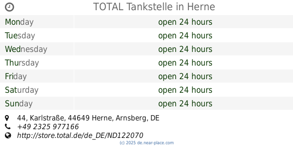
TOTAL Tankstelle
Karlstraße 44, Herne
Gas station
read more
📑
all categories
Accounting
Administrative area level 1
Administrative area level 2
Airport
Amusement park
Aquarium
Art gallery
Atm
Bakery
Bank
Bar
Beauty salon
Bicycle store
Book store
Bowling alley
Bus station
Cafe
Campground
Car dealer
Car rental
Car repair
Car wash
Casino
Cemetery
Church
City hall
Clothing store
Colloquial area
Convenience store
Country
Courthouse
Dentist
Department store
Doctor
Electrician
Electronics store
Embassy
Establishment
Finance
Fire station
Florist
Food
Funeral home
Furniture store
Gas station
General contractor
Grocery or supermarket
Gym
Hair care
Hardware store
Health
Hindu Temple
Home goods store
Hospital
Insurance agency
Jewelry store
Laundry
Lawyer
Library
Light rail station
Liquor store
Local government office
Locality
Locksmith
Lodging
Meal delivery
Meal takeaway
Mosque
Movie rental
Movie theater
Moving company
Museum
Natural feature
Neighborhood
Night club
Painter
Park
Parking
Pet store
Pharmacy
Physiotherapist
Place of worship
Plumber
Point of interest
Police
Political
Post office
Premise
Real estate agency
Restaurant
Roofing contractor
Route
Rv park, camping
School
Shoe store
Shopping mall
Spa
Stadium
Storage
Store
Subpremise
Subway station
Supermarket
Synagogue
Taxi stand
Train station
Transit station
Travel agency
University
Veterinary care
Zoo
administrative area level 3
administrative area level 4
sublocality level 1
sublocality level 2
sublocality level 3
↑